More From Contributor

£14.99
Philip`s Street Atlas Glasgow & West Central Scotland gives detailed coverage of the region in a convenient spiral-bound format. The route planner shows all the A & B roads, & can be used when driving to get close to the destination before turning to the relevant large-scale street map. The street maps show every named road, street & lane very clearly, with major roads picked out in colour. The maps are at a standard scale of 3.5 inches to 1 mile. In addition, Glasgow city centre is shown at 7 inches to 1 mile. Other information on the maps

Includes::
postcode boundaries, car parks, railway & bus stations, post offices, schools, colleges, hospitals, police & fire stations, places of worship, leisure centres, footpaths & bridleways, camping & caravan sites, golf courses, & many other places of interest. Also included are fixed single & multiple speed-camera locations, with corresponding speed limits. The comprehensive index lists street names & postcodes, plus schools, hospitals, railway stations, shopping centres & other such features picked out in red, with other places of interest shown in blue. Philip`s Street Atlas Glasgow & West Central Scotland is suitable for both business & leisure use.

...
Archived Product
£2.95
Glasgow Bellahouston in 1909 in a fascinating series of reproductions of old Ordnance Survey plans in the Alan Godfrey Editions, ideal for anyone interested in the history of their neighbourhood or family. Selected towns in Great Britain & Ireland are covered by maps showing the extent of urban development in the last decades of the 19th & early 20th century. In this title: two versions have been published for this area. The maps cover the area around Bellahouston, from Carsaig Drive & Bellahouston Drive eastward to Albert Drive, & from Edmiston Drive southward to Mosspark Drive. Mosspark, Hazelwood, Craigton & Dumbreck are also covered. Features include Bellahouston Park, White City Sports Ground, part of Albion Greyhound race course, railways including Ibrox & Bellahouston stations, tramways. The western part of the map is quite rural on the 1909 map but developed with Mosspark by 1934. Extracts from contemporary street directories on the reverse; those for 1934 including Ashdale Drive, Ashkirk Drive, Bellahouston Drive, Dumbreck Road, Mosspark Avenue, Mosspark Boulevard, Mosspark Drive, Nithsdale Road. About the Alan Godfrey Editions of the 25 ...
Archived Product
£3.50
Glasgow Bellahouston in 1909 in a fascinating series of reproductions of old Ordnance Survey plans in the Alan Godfrey Editions, ideal for anyone interested in the history of their neighbourhood or family. Two versions have been published for this area. The maps cover the area around Bellahouston, from Carsaig Drive & Bellahouston Drive eastward to Albert Drive, & from Edmiston Drive southward to Mosspark Drive. Mosspark, Hazelwood, Craigton & Dumbreck are also covered. Features include Bellahouston Park, White City Sports Ground, part of Albion Greyhound race course, railways including Ibrox & Bellahouston stations, tramways, etc. The western part of the map is quite rural on the 1909 map but developed with Mosspark by 1934. Extracts from contemporary street directories on the reverse; those for 1934 including Ashdale Drive, Ashkirk Drive, Bellahouston Drive, Dumbreck Road, Mosspark Avenue, Mosspark Boulevard, Mosspark Drive & Nithsdale Road. About the Alan Godfrey Editions of the 25” OS Series: Selected towns in Great Britain & Ireland are covered by maps showing the extent of urban development in the last decades of the 19th & early 20th century. The plans have been taken from the Ordnance Survey mapping & reprinted at about 15 inches to one mile (1:4, 340). On the reverse most maps have historical notes & many also include extracts from contemporary directories. Most maps cover about one mile (1.6kms) north/south, one & a half miles (2.4kms) across; adjoining sheets can be combined to provide wider coverage.FOR MORE INFORMATION & A COMPLETE LIST OF ALL AVAILABLE TITLES PLEASE CLICK ON THE SERIES LINK. ...
Archived Product
£3.50
Glasgow Bellahouston & Dumbreck in 1934 in a fascinating series of reproductions of old Ordnance Survey plans in the Alan Godfrey Editions, ideal for anyone interested in the history of their neighbourhood or family. Two versions have been published for this area. The maps cover the area around Bellahouston, from Carsaig Drive & Bellahouston Drive eastward to Albert Drive, & from Edmiston Drive southward to Mosspark Drive. Mosspark, Hazelwood, Craigton & Dumbreck are also covered. Features include Bellahouston Park, White City Sports Ground, part of Albion Greyhound race course, railways including Ibrox & Bellahouston stations, tramways, etc. The western part of the map is quite rural on the 1909 map but developed with Mosspark by 1934. Extracts from contemporary street directories on the reverse; those for 1934 including Ashdale Drive, Ashkirk Drive, Bellahouston Drive, Dumbreck Road, Mosspark Avenue, Mosspark Boulevard, Mosspark Drive & Nithsdale Road. About the Alan Godfrey Editions of the 25” OS Series: Selected towns in Great Britain & Ireland are covered by maps showing the extent of urban development in the last decades of the 19th & early 20th century. The plans have been taken from the Ordnance Survey mapping & reprinted at about 15 inches to one mile (1:4, 340). On the reverse most maps have historical notes & many also include extracts from contemporary directories. Most maps cover about one mile (1.6kms) north/south, one & a half miles (2.4kms) across; adjoining sheets can be combined to provide wider coverage.FOR MORE INFORMATION & A COMPLETE LIST OF ALL AVAILABLE TITLES PLEASE CLICK ON THE SERIES LINK. ...
Archived Product
£9.99
Taking you through the year day by day, The Glasgow Book of Days contains a quirky, eccentric, amusing or important event or fact from different periods of history, many of which had a major impact on the religious & political history of Scotland as a whole. Ideal for dipping into, this addictive little book will keep you entertained & informed. Featuring hundreds of snippets of information gleaned from the vaults of Glasgow`s archives, it will delight residents & visitors alike. ...
Archived Product
£3.50
Central Glasgow in 1934 in a fascinating series of reproductions of old Ordnance Survey plans in the Alan Godfrey Editions, ideal for anyone interested in the history of their neighbourhood or family. Three versions have been published for this area. Coverage stretches from West Nile Street westward to Kelvinhaugh Street & Overnewton Square, & from Renfrew Street southward to Houston Street & Wallace Street. Features include Sauchiehall Street, Blythswood Square, Central Station, Queens Dock North & South Basins, Stobcross Goods station, Charing Cross station, Cranston Hill, Finnieston, Anderston, Stobcross Quay, Lancefield Quay, Anderston Quay, Passenger Wharf. Features south of the Clyde include Kingston Dock, Springfield Quay, Clyde Place Quay, General Terminus Quay, Plantation, Plantation Quay, Mavisbank Quay, tramways & depot, east part of Princes Dock, etc. Street directory extracts are on the reverse; in the 1893 edition including Berkeley Street, Blythswood Square, Cadogan Street, Clyde Street, Stobcross Street & Union Street; in the 1934 edition including Bridge Street, Carlton Place, Cadogan Street, Stobcross Street & Union Street. About the Alan Godfrey Editions of the 25” OS Series: Selected towns in Great Britain & Ireland are covered by maps showing the extent of urban development in the last decades of the 19th & early 20th century. The plans have been taken from the Ordnance Survey mapping & reprinted at about 15 inches to one mile (1:4, 340). On the reverse most maps have historical notes & many also include extracts from contemporary directories. Most maps cover about one mile (1.6kms) north/south, one & a half miles (2.4kms) across; adjoining sheets can be combined to provide wider coverage.FOR MORE INFORMATION & A COMPLETE LIST OF ALL AVAILABLE TITLES PLEASE CLICK ON THE SERIES LINK. ...
Archived Product
£5.99
This is the savvy city breakers' pocket guide to seeing & doing more in Glasgow
- with a fun-seeking & cost-conscious slant. It
...
Archived Product
£2.99
Handy little full colour Collins map of central Glasgow with a high level of detail. Clear mapping from the park of Glasgow Green to the bustling West End. Map at a scale of 1:8200 (7.5 inches to 1 mile). Clear, detailed, full colour Collins mapping is presented in a handy format ideal for the pocket or handbag. It is excellent value & covers the most visited area of central Glasgow. It is an essential buy for tourists & residents alike.
Includes:* Detailed central area map* Around Glasgow map extending to airport, Pollok Park & Strathclyde Park* Tourist locations* Train & bus stations* Listing of major places to visit* Detailed street index
...
Archived Product
£3.50
Glasgow East End in 1893 in a fascinating series of reproductions of old Ordnance Survey plans in the Alan Godfrey Editions, ideal for anyone interested in the history of their neighbourhood or family. The map covers the eastern part of Glasgow, stretching from Gallowgate & East Nelson Street eastward to Carntyne station, & northward to Alexandra Park. Features include Camlachie Goods station, Camlachie Burn, Parkhead Forge Steel Works, Glenpark Tan Works, Vinegarhill, Dennistoun Bakery, Duke Street station, Parkhead Junction with engine shed, Carntyne Iron Works, Burnbank Bleach Dye Works, Haghill House, Carntyne Hall, Gartcraig House, etc. On the reverse are street directory extracts for Duke Street, Great Eastern Road & Gallowgate. About the Alan Godfrey Editions of the 25” OS Series: Selected towns in Great Britain & Ireland are covered by maps showing the extent of urban development in the last decades of the 19th & early 20th century. The plans have been taken from the Ordnance Survey mapping & reprinted at about 15 inches to one mile (1:4, 340). On the reverse most maps have historical notes & many also include extracts from contemporary directories. Most maps cover about one mile (1.6kms) north/south, one & a half miles (2.4kms) across; adjoining sheets can be combined to provide wider coverage.FOR MORE INFORMATION & A COMPLETE LIST OF ALL AVAILABLE TITLES PLEASE CLICK ON THE SERIES LINK. ...
Archived Product
£5.99
From the vibrant city of Glasgow, perfect for shopaholics, to the sparkling lochs & the deep, forested glens of the Trossachs, Footprint Focus Glasgow will provide you with the essential information for you to make the most of your trip. This guide contains useful tips for getting there & around, plus comprehensive listings on where to eat, sleep & party. Essentials section with useful advice on getting to & around Glasgow. Comprehensive, up-to-date listings of where to eat, sleep & play.

Includes::
information on tour operators, activities, walks & festivals. Detailed maps for Glasgow & other key areas. Slim enough to fit in your pocket. With detailed information on all the main sights, plus many lesser-known attractions, Footprint Focus Glasgow provides concise & comprehensive coverage of Scotland`s most energetic city. The content of the Footprint Focus Glasgow guide has been partially extracted from Scotland Highlands & Islands Footprint Handbook.

...
Archived Product

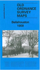
Glasgow Central 1909

Central Glasgow in 1909 in a fascinating series of reproductions of old Ordnance Survey plans in the Alan Godfrey Editions, ideal for anyone interested in the history of their neighbourhood or family. Three versions have been published for this area. Coverage stretches from West Nile Street westward to Kelvinhaugh Street and Overnewton Square, and from Renfrew Street southward to Houston Street and Wallace Street. Features include Sauchiehall Street, Blythswood Square, Central Station, Queens Dock North and South Basins, Stobcross Goods station, Charing Cross station, Cranston Hill, Finnieston, Anderston, Stobcross Quay, Lancefield Quay, Anderston Quay, Passenger Wharf. Features south of the Clyde include Kingston Dock, Springfield Quay, Clyde Place Quay, General Terminus
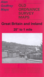
Quay, Plantation, Plantation Quay, Mavisbank Quay, tramways and depot, east part of Princes Dock, etc. Street directory extracts are on the reverse; in the 1893 edition including Berkeley Street, Blythswood Square, Cadogan Street, Clyde Street, Stobcross Street and Union Street; in the 1934 edition including Bridge Street, Carlton Place, Cadogan Street, Stobcross Street and Union Street.About the Alan Godfrey Editions of the 25” OS Series:Selected towns in Great Britain and Ireland are covered by maps showing the extent of urban development in the last decades of the 19th and early 20th century. The plans have been taken from the Ordnance Survey mapping and reprinted at about 15 inches to one mile (1:4, 340). On the reverse most maps have historical notes and many also
include extracts from contemporary directories. Most maps cover about one mile (1.6kms) north/south, one and a half miles (2.4kms) across; adjoining sheets can be combined to provide wider coverage.FOR MORE INFORMATION AND A COMPLETE LIST OF ALL AVAILABLE TITLES PLEASE CLICK ON THE SERIES LINK.
RIP - This product is no longer available on our network. It was last seen on 25.09.2019

This page now acts as a permanent archive for this product. Add more information using the comments box below to ensure it can still be found by future generations.

Use our search facility to see if it is available from an alternative contributor.
  • Availability: Out Of Stock
  • Supplier: Stanfords
  • SKU: 9780850540222
Availability: In Stock
£3.50

Product Description

Central Glasgow in 1909 in a fascinating series of reproductions of old Ordnance Survey plans in the Alan Godfrey Editions, ideal for anyone interested in the history of their neighbourhood or family. Three versions have been published for this area. Coverage stretches from West Nile Street westward to Kelvinhaugh Street & Overnewton Square, & from Renfrew Street southward to Houston Street & Wallace Street. Features include Sauchiehall Street, Blythswood Square, Central Station, Queens Dock North & South Basins, Stobcross Goods station, Charing Cross station, Cranston Hill, Finnieston, Anderston, Stobcross Quay, Lancefield Quay, Anderston Quay, Passenger Wharf. Features south of the Clyde include Kingston Dock, Springfield Quay, Clyde Place Quay, General Terminus Quay, Plantation, Plantation Quay, Mavisbank Quay, tramways & depot, east part of Princes Dock, etc. Street directory extracts are on the reverse; in the 1893 edition including Berkeley Street, Blythswood Square, Cadogan Street, Clyde Street, Stobcross Street & Union Street; in the 1934 edition including Bridge Street, Carlton Place, Cadogan Street, Stobcross Street & Union Street. About the Alan Godfrey Editions of the 25” OS Series: Selected towns in Great Britain & Ireland are covered by maps showing the extent of urban development in the last decades of the 19th & early 20th century. The plans have been taken from the Ordnance Survey mapping & reprinted at about 15 inches to one mile (1:4, 340). On the reverse most maps have historical notes & many also include extracts from contemporary directories. Most maps cover about one mile (1.6kms) north/south, one & a half miles (2.4kms) across; adjoining sheets can be combined to provide wider coverage.FOR MORE INFORMATION & A COMPLETE LIST OF ALL AVAILABLE TITLES PLEASE CLICK ON THE SERIES LINK.

Reviews/Comments

Add New

Price History

Vouchers

No voucher codes found.
Do you know a voucher code for this product or supplier? Add it to Insights for others to use.

Facebook

Jargon Buster

Contemporary - Modern era design
Contemporary - A design reference to indicate post war modern design
History - Anything that happens in the past. An acedemic subject.
Contemporary - An object that is living in the same time.
Ideal - Something that satisfies a perfect criteria.
Family - A group of people that live together made up from parents and children.

Supplier Information

Stanfords
Stanfords was established in 1853 and opened their iconic Covent Garden flagship store in 1901. They have become the top retailer of maps, travel books and accessories in the UK and arguably offer the largest selection of maps and travel books worldwide. Famous names such as Captain Robert Falcon Scott, Ranulph Fiennes and Michael Palin have purchased from Stanfords. They now have a shop in Bristol and both stores together with other venues operate a calendar of events including talks, book signings and exhibitions. As a specialist map retailer, the map selection is comprehensive and includes road maps, street maps and walking maps from worldwide destinations, as well as a selection of world atlases and wall maps. Books include travel guides and travel literature. Stanfords also stock globes, from miniatures made of blue marble to magnificent floor-standing globes. The website features a selection of interesting articles on travel topics.
Page Updated: 2023-11-12 20:15:36

Community Generated Product Tags

Oh No! The productWIKI community hasn't generated any tags for this product yet!
Menu