
 United Kingdom
 France
 Germany
 Netherlands
 Sweden
 USA
USA
 Italy
Italy
 Spain
Spain
More From Contributor


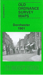
Dorchester 1901
Dorchester in 1901 in a fascinating series of reproductions of old Ordnance Survey plans in the Alan Godfrey Editions, ideal for anyone interested in the history of their neighbourhood or family. Two versions have been published for this area. High West Street and High East Street run down the centre of the map, and coverage stretches westward to Poundbury Camp, eastward to Grey`s Bridge and Fordington Cross, and south to Maumbury Ring. Features include both railway stations, Dorchester Brewery, Fordington, Borough Gardens, Colliton Park, prison (left blank), St George`s church, St Peter`s church, Northernhay, workhouse, Infantry Barracks, Royal Horse Artllery Barracks, Roman defences, River Frome, Coker`s Frome, etc. The 1886 version is in colour, taken from the
beautiful 1st Edition OS hand-coloured map and includes on the reverse a list of private residents from an 1895 directory. About the Alan Godfrey Editions of the 25” OS SeriesSelected towns in Great Britain and Ireland are covered by maps showing the extent of urban development in the last decades of the 19th and early 20th century. The plans have been taken from the Ordnance Survey mapping and reprinted at about 15 inches to one mile (1:4, 340). On the reverse most maps have historical notes and many also include extracts from contemporary directories. Most maps cover about one mile (1.6kms) north/south, one and a half miles (2.4kms) across; adjoining sheets can be combined to provide wider coverage.FOR MORE INFORMATION AND A COMPLETE LIST OF ALL AVAILABLE TITLES PLEASE CLICK ON THE
SERIES LINK.

Product Description
Reviews/Comments
Add New
Intelligent Comparison
Archived Product
Chester 1908 Stanfords
£3.50
Archived Product

Colchester 1896 Stanfords
£3.50
Archived Product
Colchester 1805 Stanfords
£7.99
Archived Product

Colchester 1898 Stanfords
£9.99
Archived Product
Manchester 1903 Stanfords
£7.99
Archived Product

Dorchester Days Stanfords
£24.95
Archived Product
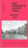
Bicester 1919 Stanfords
£3.50
Archived Product
Worchester C.1804-1810 Stanfords
£95.00
Vouchers
No voucher codes found.
Do you know a voucher code for this product or supplier? Add it to Insights for others to use.
Do you know a voucher code for this product or supplier? Add it to Insights for others to use.
 Denmark