
 United Kingdom
 France
 Germany
 Netherlands
 Sweden
 USA
USA
 Italy
Italy
 Spain
Spain
More From Contributor


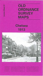
Chelsea 1913
Chelsea in 1913 in a fascinating series of reproductions of old Ordnance Survey plans in the Alan Godfrey Editions, ideal for anyone interested in the history of their neighbourhood or family. Three versions have been published for this area, stretching from Stamford Bridge football ground eastward to Sloane Avenue and Royal Avenue; and from Harrington Gardens southward to Battersea Bridge. Features include the Kings Road, Beaufort Street, Sydney Street, Fulham Road, Old Brompton Road, Sutton Model Dwellings, Cheyne Walk, Albert Bridge, Cadogan Pier, Moravian Burial Ground, Town Hall, Chelsea Workhouse, St Luke`s church, St George`s (later Union) Workhouse, Brompton Cemetery, The Boltons, West Brompton station, Walham Green station, Chelsea station, Western Hospital,
St Mark`s College. Earls Court station is in the north-west corner. A small portion of Battersea Park is in the south-east corner.About the Alan Godfrey Editions of the 25” OS Series:Selected towns in Great Britain and Ireland are covered by maps showing the extent of urban development in the last decades of the 19th and early 20th century. The plans have been taken from the Ordnance Survey mapping and reprinted at about 15 inches to one mile (1:4, 340). On the reverse most maps have historical notes and many also include extracts from contemporary directories. Most maps cover about one mile (1.6kms) north/south, one and a half miles (2.4kms) across; adjoining sheets can be combined to provide wider coverage.FOR MORE INFORMATION AND A COMPLETE LIST OF ALL AVAILABLE TITLES PLEASE CLICK
ON THE SERIES LINK.

Product Description
Reviews/Comments
Add New
Intelligent Comparison
Archived Product

Chelsea 1865 Stanfords
£3.50
Archived Product
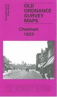
Chesham 1923 Stanfords
£3.50
Vouchers
No voucher codes found.
Do you know a voucher code for this product or supplier? Add it to Insights for others to use.
Do you know a voucher code for this product or supplier? Add it to Insights for others to use.
 Denmark