More From Contributor
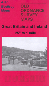
£3.99
This guide to Cambridge & East Anglia

Includes::
a chapter detailing Cambridge & East Anglia's history & culture,

...
Archived Product
£3.99
This is a new edition in the AA's ground-breaking series of street atlases. It is fully revised & updated for 2007. Street by Street Cambridge Midi has been fully updated with a stylish new cover design, in a handy glovebox size. The maps clearly show AA recommended restaurants, pubs, hotels, one-way streets & car parks. 24-hour petrol stations & garden centres are highlighted & the mapping uses National Grid referencing
- used by the emergency services. Featuring a clever use of colour to ensure they can be read under street lighting, these maps are all you need to find your way in Cambridge.
...
Archived Product
£12.00
Cambridge in the Cities of the Imagination guide series; providing an in-depth cultural & historical exploration of some of the great city landscapes of the world. Presented as a cultural & literary guide, each title in the series explores the history of the city, providing an overview of the city’s development from its earliest roots to the modern day. Particular emphasis is placed on the literary, poetic, architectural, cultural & historical elements that make up the city & each title is written & researched by an academic expert. An Epilogue offers thoughts on the future of the city, suggested further reading & indices of literary & historical names & famous places & attractions. ...
Archived Product
£14.99
Cambridge, Royston, Duxford & Linton area on a detailed topographic & GPS compatible map No. 209, waterproof version, from the Ordnance Survey’s 1:25, 000 Explorer series.MOBILE DOWNLOADS: this title & all the other OS Explorer maps include a code for downloading after purchase the digital version onto your smartphone or tablet for viewing on the OS smartphone app.OS EXPLORER SERIES: to see the list of all the titles in the OS Explorer series, both paper & waterproof versions, please click on the series link. The Explorer series, Ordnance Survey’s most detailed maps recommended for anyone enjoying outdoor activities, provides topographic coverage of Great Britain at 1:25, 000 on GPS compatible maps with hiking trails, cycling routes & extensive tourist information. Each printed map is available either on paper or as a waterproof & tear-resistant OS Active Map, as indicated in its title. Britain’s National Parks & other areas of particular tourist interest are presented on often double-sided OL (Outdoor Leisure) maps, whilst most standard format Explorers cover an area of 30 x 20km (approx. 19 x 12 miles). All three versions (paper, waterproof & digital) are the same & provide plenty of recreational & tourist information, indicating the traditional public right of way paths (except in Scotland where different laws apply), including bridleways & byways. National Trails & other long-distance paths are marked, as well as permissive footpaths or bridleways & on-road or traffic-free cycle routes with, where appropriate, their National/ Regional Cycle Network numbers. Boundaries of access land are clearly marked. A wide range of symbols provides additional tourist information, highlighting camping & caravanning sites, information offices & visitors’ centres, parking & picnicking places, country pubs, sport & recreational facilities including cycle hire locations & mountain biking trails, historic buildings & museums, etc. Exceptionally clear presentation of the landscape is provided by contours at 5m or in the uplands at 10m intervals, with additional spot heights plus colouring and/or graphics for different types of woodlands, orchards, heath, marshl&, scree or boulders, & other topographic features. For GPS users the maps have British National Grid lines at 1km intervals, with latitude & longitude given by margin ticks at 1`. Clearly laid out map legend

Includes::
French & German translations for the tourist information symbols.

...
Archived Product
£8.99
Cambridge, Royston, Duxford & Linton area on a detailed topographic & GPS compatible map No. 209, paper version, from the Ordnance Survey’s 1:25, 000 Explorer series.MOBILE DOWNLOADS: this title & all the other OS Explorer maps include a code for downloading after purchase the digital version onto your smartphone or tablet for viewing on the OS smartphone app.OS EXPLORER SERIES: to see the list of all the titles in the OS Explorer series, both paper & waterproof versions, please click on the series link. The Explorer series, Ordnance Survey’s most detailed maps recommended for anyone enjoying outdoor activities, provides topographic coverage of Great Britain at 1:25, 000 on GPS compatible maps with hiking trails, cycling routes & extensive tourist information. Each printed map is available either on paper or as a waterproof & tear-resistant OS Active Map, as indicated in its title. Britain’s National Parks & other areas of particular tourist interest are presented on often double-sided OL (Outdoor Leisure) maps, whilst most standard format Explorers cover an area of 30 x 20km (approx. 19 x 12 miles). All three versions (paper, waterproof & digital) are the same & provide plenty of recreational & tourist information, indicating the traditional public right of way paths (except in Scotland where different laws apply), including bridleways & byways. National Trails & other long-distance paths are marked, as well as permissive footpaths or bridleways & on-road or traffic-free cycle routes with, where appropriate, their National/ Regional Cycle Network numbers. Boundaries of access land are clearly marked. A wide range of symbols provides additional tourist information, highlighting camping & caravanning sites, information offices & visitors’ centres, parking & picnicking places, country pubs, sport & recreational facilities including cycle hire locations & mountain biking trails, historic buildings & museums, etc. Exceptionally clear presentation of the landscape is provided by contours at 5m or in the uplands at 10m intervals, with additional spot heights plus colouring and/or graphics for different types of woodlands, orchards, heath, marshl&, scree or boulders, & other topographic features. For GPS users the maps have British National Grid lines at 1km intervals, with latitude & longitude given by margin ticks at 1`. Clearly laid out map legend

Includes::
French & German translations for the tourist information symbols.

...
Archived Product
£4.95
Cambridge Street Atlas from the Geographers` A-Z Map Company in a paperback format slightly smaller than A5. Map scale is 1:15, 840 (4” to a mile), with an enlargement showing the town centre of Cambridge in greater detail at 1:7, 920 (8” to 1 mile). Coverage

Includes::
Bar Hill, Barton, Comberton, Cottenham, Fulbourn, Girton, Great Shelford, Hardwick, Haslingfield, Hauxton, Histon, Longstanton, Milton, Oakington, Stapleford & Waterbeach. Current edition of this title was published in 2012. To see other titles in this series of A-Z street atlases of towns & cities please click on the series link. A-Z also publish a series of County Street Atlases, for a list of titles in that series please search for SI00000917.A-Z street atlases present motorways plus A & B roads highlighted by colouring & shown with route numbers. One way or restricted access streets & car parks are marked, as are in more recently published titles locations of speed cameras. Also shown are selected cycleway routes. Where appropriate, A & B roads are annotated with selected house numbers for easier identification of addresses. Railway lines are shown with stations & level crossings. Colouring indicates different types of buildings: educational, hospitals & healthcare, industrial, leisure & recreational, shopping centres & markets, public buildings, & places of interest. Symbols mark locations of facilities usually indicated on street mapping: post offices, emergency services, public toilets, etc. Also marked are postcode & local authority boundaries. Each page has the lines & coordinates of the British National Grid. The indexes list streets, places & areas, hospitals, industrial estates, blocks of flats on housing estates, railway stations, & selected places o interest; the latter are printed in contrasting colouring to make them easier to find.

...
Archived Product
£5.59
Map No. 154, Cambridge & Newmarket, in the Ordnance Survey Landranger series at 1:50, 000, including Saffron Walden, Haverhill, Great Sampford, Steeple Bumpstead, Wendens Ambo, Barkway, Elmdon, Barley, Royston, Great Chesterford, Ashton, Linton, Duxford, Melbourn, Shepreth, Sawston, Orwell, Kingston, Comberton, Great Shelford, Fulbourn, Horseheath, Balsham, Great Thurlow, Brinkley, Lidgate, Dullingham, Swaffham Bulbeck, Waterbeach, Burwell, Moulton, Red Lodge, Fordham, Workington, Soham, Wicken, Hardwick, Histon, Bar Hill, Milton, Cottenham, Fen Drayton, Willingham Needingworth & Aldreth, plus part of the E2 European Long Distance Path. Edition D2; Revised for selected changes 2009; Copyright 2009 This title is also available on our website in a waterproof & tear-resistant version. Maps in this series are only published folded. Stanfords can also print flat versions of Ordnance Survey maps through the OS Select system, centring the map on a location of your choice & with a picture provided by you on the cover. For more information please click on the link at the bottom of this description. About Ordnance Survey ...
Archived Product
£7.99
Map No. 154, Cambridge & Newmarket 1805-1836, in the Cassini Historical Series of old Ordnance Survey mapping of England & Wales at 1:50, 000 in a format designed to offer a convenient comparison with the present day coverage from the OS, & most locations in three different editions. Old historical maps have been combined so that the sheet lines correspond to the current Landranger series & reproduced with the scale changed from one inch to one mile to 1:50, 000. Most locations are covered by three separate maps, showing how the area has changed over the decades, with selected major cities also presented in a fourth edition. Old Series: the first detailed survey mapping dating for most areas from the first half of the 19th century, in black & white & with relief shown by hachuring. Revised New Series from 1880s/1900s, with some colouring & a mixture of hachuring & contour lines. Popular Edition from the inter-war years, with contour lines & colouring to indicate woodlands, parks, etc. New Popular Edition from the late 1940s, reproduced in the Cassini series for the major cities. Each map

Includes::
notes on the development of Ordnance Survey & the various series produced by them. For those interested in maps & cartography in general, the Cassini series also provides a fascinating insight into how Ordnance Survey cartographic style has developed over a period of over 100 years. Coverage in this title

Includes::
present day Saffron Walden, Haverhill, Great Sampford, Steeple Bumpstead, Wendens Ambo, Barkway, Elmdon, Barley, Royston, Great Chesterford, Ashton, Linton, Duxford, Melbourn, Shepreth, Sawston, Orwell, Kingston, Comberton, Great Shelford, Fulbourn, Horseheath, Balsham, Great Thurlow, Brinkley, Lidgate, Dullingham, Swaffham Bulbeck, Waterbeach, Burwell, Moulton, Red Lodge, Fordham, Workington, Soham, Wicken, Hardwick, Histon, Bar Hill, Milton, Cottenham, Fen Drayton, Willingham Needingworth & Aldreth. PLEASE NOTE: Stanfords can also print on request mapping from all four series centring the map on a location of your choice. For more information please click on the link below.


...
Archived Product
£14.99
Map No. 154, Cambridge & Newmarket 1805-1921 (3-map set), in the Cassini Historical Series of old Ordnance Survey mapping of England & Wales at 1:50, 000 in a format designed to offer a convenient comparison with the present day coverage from the OS, & most locations in three different editions. Old historical maps have been combined so that the sheet lines correspond to the current Landranger series & reproduced with the scale changed from one inch to one mile to 1:50, 000. Most locations are covered by three separate maps, showing how the area has changed over the decades, with selected major cities also presented in a fourth edition. Old Series: the first detailed survey mapping dating for most areas from the first half of the 19th century, in black & white & with relief shown by hachuring. Revised New Series from 1880s/1900s, with some colouring & a mixture of hachuring & contour lines. Popular Edition from the inter-war years, with contour lines & colouring to indicate woodlands, parks, etc. New Popular Edition from the late 1940s, reproduced in the Cassini series for the major cities. Each map

Includes::
notes on the development of Ordnance Survey & the various series produced by them. For those interested in maps & cartography in general, the Cassini series also provides a fascinating insight into how Ordnance Survey cartographic style has developed over a period of over 100 years. Coverage in this title

Includes::
present day Saffron Walden, Haverhill, Great Sampford, Steeple Bumpstead, Wendens Ambo, Barkway, Elmdon, Barley, Royston, Great Chesterford, Ashton, Linton, Duxford, Melbourn, Shepreth, Sawston, Orwell, Kingston, Comberton, Great Shelford, Fulbourn, Horseheath, Balsham, Great Thurlow, Brinkley, Lidgate, Dullingham, Swaffham Bulbeck, Waterbeach, Burwell, Moulton, Red Lodge, Fordham, Workington, Soham, Wicken, Hardwick, Histon, Bar Hill, Milton, Cottenham, Fen Drayton, Willingham Needingworth & Aldreth. PLEASE NOTE: Stanfords can also print on request mapping from all four series centring the map on a location of your choice. For more information please click on the link below.


...
Archived Product
£9.99
Map No. 154, Cambridge & Newmarket 1898-1901, in the Cassini Historical Series of old Ordnance Survey mapping of England & Wales at 1:50, 000 in a format designed to offer a convenient comparison with the present day coverage from the OS, & most locations in three different editions. Old historical maps have been combined so that the sheet lines correspond to the current Landranger series & reproduced with the scale changed from one inch to one mile to 1:50, 000. Most locations are covered by three separate maps, showing how the area has changed over the decades, with selected major cities also presented in a fourth edition. * Old Series: the first detailed survey mapping dating for most areas from the first half of the 19th century, in black & white & with relief shown by hachuring.* Revised New Series from 1880s/1900s, with some colouring & a mixture of hachuring & contour lines.* Popular Edition from the inter-war years, with contour lines & colouring to indicate woodlands, parks, etc.* New Popular Edition from the late 1940s, reproduced in the Cassini series for the major cities. Each map

Includes::
notes on the development of Ordnance Survey & the various series produced by them. For those interested in maps & cartography in general, the Cassini series also provides a fascinating insight into how Ordnance Survey cartographic style has developed over a period of over 100 years. Coverage in this title

Includes::
present day Saffron Walden, Haverhill, Great Sampford, Steeple Bumpstead, Wendens Ambo, Barkway, Elmdon, Barley, Royston, Great Chesterford, Ashton, Linton, Duxford, Melbourn, Shepreth, Sawston, Orwell, Kingston, Comberton, Great Shelford, Fulbourn, Horseheath, Balsham, Great Thurlow, Brinkley, Lidgate, Dullingham, Swaffham Bulbeck, Waterbeach, Burwell, Moulton, Red Lodge, Fordham, Workington, Soham, Wicken, Hardwick, Histon, Bar Hill, Milton, Cottenham, Fen Drayton, Willingham Needingworth & Aldreth.* PLEASE NOTE: Stanfords can also print on request mapping from all four series *centring the map on a location of your choice.* For more information please click on the link below.


...
Archived Product

Cambridge 1925

Cambridge in 1925 in a fascinating series of reproductions of old Ordnance Survey plans in the Alan Godfrey Editions, ideal for anyone interested in the history of their neighbourhood or family.Tthe map gives good coverage of this historic city, extending from Great Bridge and Merton Hall southward to Sheeps Green, Leys School and Russell Street; and from Selwyn College and Newnham College eastward to Sturton Street and Gwydir Street. A fragment of railway is in the south-eastern corner but the station is off the map. Features include Kings College, Clare College, Trinity College, St John`s College, River Cam, Market Hill, Peterhouse, Addenbrooke`s Hospital, Downing College, Parker`s Piece, Emmanuel College, Christ`s College, Sidney Sussex College, Jesus College, Butt
Green, Pembroke College, Fitzwilliam Museum, Queen`s College, St Catherine`s College, Newtown, Barnwell, Mill Road, East Road, cemetery, Newmarket Road and St Matthew`s Piece. On the reverse are street directories for Earl Street, East Road, Glisson Road, Sidney Street and Silver Street.About the Alan Godfrey Editions of the 25” OS Series:Selected towns in Great Britain and Ireland are covered by maps showing the extent of urban development in the last decades of the 19th and early 20th century. The plans have been taken from the Ordnance Survey mapping and reprinted at about 15 inches to one mile (1:4, 340). On the reverse most maps have historical notes and many also include extracts from contemporary directories. Most maps cover about one mile (1.6kms) north/south, one
and a half miles (2.4kms) across; adjoining sheets can be combined to provide wider coverage.FOR MORE INFORMATION AND A COMPLETE LIST OF ALL AVAILABLE TITLES PLEASE CLICK ON THE SERIES LINK.
RIP - This product is no longer available on our network. It was last seen on 25.09.2019

This page now acts as a permanent archive for this product. Add more information using the comments box below to ensure it can still be found by future generations.

Use our search facility to see if it is available from an alternative contributor.
  • External links may include paid for promotion
  • Availability: Out Of Stock
  • Supplier: Stanfords
  • SKU: 9780850544329
Availability: In Stock
£3.50

Product Description

Cambridge in 1925 in a fascinating series of reproductions of old Ordnance Survey plans in the Alan Godfrey Editions, ideal for anyone interested in the history of their neighbourhood or family. Tthe map gives good coverage of this historic city, extending from Great Bridge & Merton Hall southward to Sheeps Green, Leys School & Russell Street; & from Selwyn College & Newnham College eastward to Sturton Street & Gwydir Street. A fragment of railway is in the south-eastern corner but the station is off the map. Features include Kings College, Clare College, Trinity College, St John`s College, River Cam, Market Hill, Peterhouse, Addenbrooke`s Hospital, Downing College, Parker`s Piece, Emmanuel College, Christ`s College, Sidney Sussex College, Jesus College, Butt Green, Pembroke College, Fitzwilliam Museum, Queen`s College, St Catherine`s College, Newtown, Barnwell, Mill Road, East Road, cemetery, Newmarket Road & St Matthew`s Piece. On the reverse are street directories for Earl Street, East Road, Glisson Road, Sidney Street & Silver Street. About the Alan Godfrey Editions of the 25” OS Series: Selected towns in Great Britain & Ireland are covered by maps showing the extent of urban development in the last decades of the 19th & early 20th century. The plans have been taken from the Ordnance Survey mapping & reprinted at about 15 inches to one mile (1:4, 340). On the reverse most maps have historical notes & many also include extracts from contemporary directories. Most maps cover about one mile (1.6kms) north/south, one & a half miles (2.4kms) across; adjoining sheets can be combined to provide wider coverage.FOR MORE INFORMATION & A COMPLETE LIST OF ALL AVAILABLE TITLES PLEASE CLICK ON THE SERIES LINK.

Reviews/Comments

Add New

Price History

Vouchers

No voucher codes found.
Do you know a voucher code for this product or supplier? Add it to Insights for others to use.

Facebook

Jargon Buster

Contemporary - Modern era design
Silver - A colour based on the colour of the metal
Silver - A chemical element, metalic. Has the highest elctrical conductance of any element. Also known for its exceptional anitmicrobal properties
Contemporary - A design reference to indicate post war modern design
History - Anything that happens in the past. An acedemic subject.
Road - a manmade lane or a path that is used to speed up travel.
Contemporary - An object that is living in the same time.
Mill - A building which can grind grain into flour.
Hall - A room at the inside of an entrance of a house.
Museum - A building which exhibits old artefacts for viewing of people who show interest.
Ideal - Something that satisfies a perfect criteria.
Family - A group of people that live together made up from parents and children.

Supplier Information

Stanfords
Stanfords was established in 1853 and opened their iconic Covent Garden flagship store in 1901. They have become the top retailer of maps, travel books and accessories in the UK and arguably offer the largest selection of maps and travel books worldwide. Famous names such as Captain Robert Falcon Scott, Ranulph Fiennes and Michael Palin have purchased from Stanfords. They now have a shop in Bristol and both stores together with other venues operate a calendar of events including talks, book signings and exhibitions. As a specialist map retailer, the map selection is comprehensive and includes road maps, street maps and walking maps from worldwide destinations, as well as a selection of world atlases and wall maps. Books include travel guides and travel literature. Stanfords also stock globes, from miniatures made of blue marble to magnificent floor-standing globes. The website features a selection of interesting articles on travel topics.
Page Updated: 2023-11-12 20:15:36

Community Generated Product Tags

Oh No! The productWIKI community hasn't generated any tags for this product yet!
Menu