
 United Kingdom
 France
 Germany
 Netherlands
 Sweden
 USA
USA
 Italy
Italy
 Spain
Spain
More From Contributor


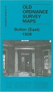
Bolton East 1908
Bolton East in 1908 in a fascinating series of reproductions of old Ordnance Survey plans in the Alan Godfrey Editions, ideal for anyone interested in the history of their neighbourhood or family. The map covers the eastern part of Bolton, extending eastward to Breightmet Fold Lane, southward to Darcy Lever; Burnden Park football ground is in the bottom left corner. Features include Tonge Cemetery, River Tonge, part of Haulgh, Manchester Bolton & Bury Canal, Lever Bridge Mills, Darcy Lever station, Tonge Fold, Crompton Fold Pit, Oaken Bottom Mill, Burnden Bleach Works, St Stephen`s church, Croft Side Colliery, Breightmet Colliery, St James church, Tonge Colliery, Darcy Lever Hall, Clap Row, Flearbottom, etc. On the reverse is a selection of street directory entries,
including Bradford Street, Bury New Road, Bury Old Road, Castle Street and Radcliffe Road.About the Alan Godfrey Editions of the 25” OS Series:Selected towns in Great Britain and Ireland are covered by maps showing the extent of urban development in the last decades of the 19th and early 20th century. The plans have been taken from the Ordnance Survey mapping and reprinted at about 15 inches to one mile (1:4, 340). On the reverse most maps have historical notes and many also include extracts from contemporary directories. Most maps cover about one mile (1.6kms) north/south, one and a half miles (2.4kms) across; adjoining sheets can be combined to provide wider coverage.FOR MORE INFORMATION AND A COMPLETE LIST OF ALL AVAILABLE TITLES PLEASE CLICK ON THE SERIES LINK.
including Bradford Street, Bury New Road, Bury Old Road, Castle Street and Radcliffe Road.About the Alan Godfrey Editions of the 25” OS Series:Selected towns in Great Britain and Ireland are covered by maps showing the extent of urban development in the last decades of the 19th and early 20th century. The plans have been taken from the Ordnance Survey mapping and reprinted at about 15 inches to one mile (1:4, 340). On the reverse most maps have historical notes and many also include extracts from contemporary directories. Most maps cover about one mile (1.6kms) north/south, one and a half miles (2.4kms) across; adjoining sheets can be combined to provide wider coverage.FOR MORE INFORMATION AND A COMPLETE LIST OF ALL AVAILABLE TITLES PLEASE CLICK ON THE SERIES LINK.

Product Description
Reviews/Comments
Add New
Vouchers
No voucher codes found.
Do you know a voucher code for this product or supplier? Add it to Insights for others to use.
Do you know a voucher code for this product or supplier? Add it to Insights for others to use.
 Denmark