More From Contributor
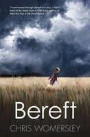
£9.99
One of the titles in a series of contoured outdoor leisure maps, extending F&B’s extensive coverage of Austria to the neighbouring regions & other popular hiking areas of Germany. The maps have contours at 100-metre intervals in the mountainous areas, & 50 metres elsewhere, shading & graphic relief. An overprint highlights hiking paths, cycling routes &, on most of the titles, ski routes. The maps also show youth hostels, campsites, mountain huts & refuges. Margin ticks show latitude & longitude in steps of 5`. Most titles also give GPS waypoints, as indicated in the individual descriptions. Map legend

Includes::
English. Several of the titles come with a separate booklet, in German only, containing information on places of interest, brief descriptions of selected hiking trails, addresses of various accommodation facilities, etc. This double-sided map covers an area centred on Berchtesgaden, extending from Bad Reichenhall to the Austrian border. GPS waypoints are shown & listed in the accompanying text surrounding the map. Descriptions of places of interest, hiking suggestions, & a list of huts & refuges are in German only.

...
Archived Product
£13.99
Map No. 14, Berchtesgadener Land
- Chiemgauer Alps, in a series of hiking maps from Kompass providing extensive coverage of Austria
...
Archived Product
£8.95
Map No. 14, Berchtesgadener Land
- Chiemgauer Alps, in a series of hiking maps from Kompass providing extensive coverage of Austria
...
Archived Product
£13.99
Berchtesgadener Land – Köningssee area of the German Alps on a detailed, GPS compatible map at 1:50, 000 from Kompass with local & long-distance footpaths, cycling routes, accommodation, etc, printed on durable, waterproof & tear-resistant synthetic paper. KOMPASS HIKING & RECREATIONAL MAPS: This title is part of an extensive series covering Austria, much of Germany & the Slovenian Alps. Kompass are Europe’s largest publishers of hiking maps; their mapping of other countries, including expanding coverage of Italy, is listed on our website separately.CARTOGRAPHY: The maps are contoured with additional shading, graphic relief & colouring to provide a more detailed picture of the terrain, vegetation and/or land use. Contour interval varies from 10m in the coastal areas of Northern Germany to 40 or 50 metres in the mountainous regions. All the maps highlight local & long-distance waymarked footpaths, including climbing trails. Most titles also show cycling routes, mountain bike trails, &, the in mountainous areas, ski routes. The maps indicate various types of accommodation (selected inns & hotels, youth hostels, campsites, mountain refuges), as well as recreational facilities, places of interest, etc. Latest editions also show access by public transport with bus stops and/or Park+ Ride facilities.GEOGRAPHICAL COORDINATES: Unless indicated to the contrary in the individual description, the maps have a UTM grid for GPS users. MAP LEGEND: Most maps now include full English legend, particularly titles covering the Alpine areas. Some maps covering mainly eastern Austria or the less popular parts of Germany may still have a legend in German only.OTHER
Features: Selected titles include on the reverse panorama drawings of their area with names of villages, peaks, valleys, etc. and/or have a booklet with pictures of local wild flowers with their Latin names. Many titles are now published as competitively priced sets of two or more maps, offering a wider coverage.BOOKLETS: PLEASE NOTE BEFORE ORDERING! Many titles come with a booklet describing the area and/or various hiking routes. Unless indicated in the individual description that the booklet

Includes::
English, these booklets are IN GERMAN only. The booklets are not necessary to use the maps since, as stated above, full English language map legend is provided.


...
Archived Product
£6.50
Topographic coverage of mainland Spain at 1:25, 000 published by the Centro Nacional de Información Geograficá, the country’s civilian survey organization. The maps have contours at 10m intervals & colouring and/or graphics to show different types of vegetation or land use. Boundaries of national parks & other protected areas are marked. In addition to all the usual information shown on topographic maps at this scale, detailed presentation of the road & rail networks, rural tracks & paths, etc, the maps also show campsites. The maps have a 1-km UTM grid, with margin ticks for latitude & longitude at 1` intervals. Map legend is in Spanish only.PLEASE NOTE: our grid for the whole of Spain is in preparation
- in the meantime, for areas other than those shown on the attached grid please use CNIG’s topographic survey at 1:50, 000 by searching for ‘SI00000832’. Each 25K map covers one quarter of the corresponding 50K map, with the numbering system: I = NW quarter, II = NE quarter, III = SW quarter & IV = SE quarter. CNIG maps in the Provincial Road Maps series at 1:200, 000 are overprinted with the grid for the 1:50, 000 survey & can be used to see the area covered by each 50K or 25K title in more detail. To see the list of titles in this series please click on the series grid
- for map numbers not yet listed on our website please contact us by email.

...
Archived Product
£20.00
Painstakingly restored from Tolkien`s manuscripts & presented for the first time as a continuous & standalone story, the epic tale of Beren & Luthien will reunite fans of The Hobbit & The Lord of the Rings with Elves & Men, Dwarves & Orcs & the rich landscape & creatures unique to Tolkien`s Middle-earth. The tale of Beren & Luthien was, or became, an essential element in the evolution of The Silmarillion, the myths & legends of the First Age of the World conceived by J.R.R. Tolkien. Returning from France & the battle of the Somme at the end of 1916, he wrote the tale in the following year. Essential to the story, & never changed, is the fate that shadowed the love of Beren & Luthien: for Beren was a mortal man, but Luthien was an immortal Elf. Her father, a great Elvish lord, in deep opposition to Beren, imposed on him an impossible task that he must perform before he might wed Luthien. This is the kernel of the legend; & it leads to the supremely heroic attempt of Beren & Luthien together to rob the greatest of all evil beings, Melkor, called Morgoth, the Black Enemy, of a Silmaril. In this book Christopher Tolkien has attempted to extract the story of Beren & Luthien from the comprehensive work in which it was embedded; but that story was itself changing as it developed new associations within the larger history. To show something of the process whereby this legend of Middle-earth evolved over the years, he has told the story in his father`s own words by giving, first, its original form, & then passages in prose & verse from later texts that illustrate the narrative as it changed. Presented together for the first time, they reveal aspects of the story, both in event & in narrative immediacy, that were afterwards lost. ...
Archived Product
£8.99
Painstakingly restored from Tolkien`s manuscripts & presented for the first time as a continuous & standalone story, the epic tale of Beren & Luthien will reunite fans of The Hobbit & The Lord of the Rings with Elves & Men, Dwarves & Orcs & the rich landscape & creatures unique to Tolkien`s Middle-earth. The tale of Beren & Luthien was, or became, an essential element in the evolution of The Silmarillion, the myths & legends of the First Age of the World conceived by J.R.R. Tolkien. Returning from France & the battle of the Somme at the end of 1916, he wrote the tale in the following year. Essential to the story, & never changed, is the fate that shadowed the love of Beren & Luthien: for Beren was a mortal man, but Luthien was an immortal Elf. Her father, a great Elvish lord, in deep opposition to Beren, imposed on him an impossible task that he must perform before he might wed Luthien. This is the kernel of the legend; & it leads to the supremely heroic attempt of Beren & Luthien together to rob the greatest of all evil beings, Melkor, called Morgoth, the Black Enemy, of a Silmaril. In this book Christopher Tolkien has attempted to extract the story of Beren & Luthien from the comprehensive work in which it was embedded; but that story was itself changing as it developed new associations within the larger history. To show something of the process whereby this legend of Middle-earth evolved over the years, he has told the story in his father`s own words by giving, first, its original form, & then passages in prose & verse from later texts that illustrate the narrative as it changed. Presented together for the first time, they reveal aspects of the story, both in event & in narrative immediacy, that were afterwards lost. ...
Archived Product
£12.99
Topographic survey of Catalonia at 1:25, 000 from the Institut Cartogràfic i Geològic de Catalunya, an attractive alternative to Spain’s national topographic survey at this scale, offering a much larger area per sheet with extensive tourist information & vivid presentation of vegetation & land use. These large, detailed maps have contours at 10m intervals enhanced by hill shading & fine colouring and/or graphics to portray of vegetation or land use (different types of woodlands, marshl&, vineyards, crops, etc). An overprint highlights waymarked local & long-distance GR footpaths plus CT cycling routes. Also highlighted are picturesque locations such as villages, isolated buildings or natural features. A very wide range of symbols indicate various facilities, places of interest & recreational sites: tourist information centres, campsites & other rural accommodation, cultural heritage, vineries, wildlife observation areas, viewpoints & beauty spots, sites for recreational pursuits including horse riding, water sports, paragliding, etc The maps are divided by the publishers into three types: Administrative Units, Natural Protected Areas, & Geographical Areas, as shown on our grid for this series. Coverage by each sheet varies; most maps present an area of 30 x 23km (19 x 14km approx). The maps have a 1km UTM grid, with latitude & longitude values shown for the map corners. Excellently presented topographic map legend is in Catalan only but the legend for the tourist information & the road network

Includes::
English. To see the list of all the titles in this series please click on the series link.

...
Archived Product
£9.99
Bergamo at 1:10, 000 on an indexed street plan from Litografia Artistica Cartografica, with a detailed enlargement of the city’s historic centre at 1:7, 000. 41 monuments including historic buildings & churches, cultural or educational institutions, & important municipal buildings or facilities are numbered & listed next to the plan. Coverage extends south to include access to the city’s airport at Orio al Serio. Litografia Artistica Cartografica (LAC) are Italy’s leading publishers of street plans with an extensive range of titles. Where appropriate, the plans include an enlargement showing the historic centre in greater detail. On each plan monuments including historic buildings & churches, archaeological sites, cultural or educational institutions, & important municipal buildings or facilities are numbered & listed next to the plan. Unless indicated to the contrary in the individual description, one way streets are not marked. Street index is on the reverse. ...
Archived Product
£7.95
Bergamo Province in a series of handy size road maps from Litografia Artistica Cartografica (LAC) with more minor local roads & tracks than can be found on most regional maps. The series is gradually being changed to a new style of digitally derived cartography, so presentation of adjoining titles may vary. All the maps have hill shading to represent the general relief with spot heights for selected peaks, & show a few more local roads & rough tracks than the other road map series. Intermediate road distances are indicated. Regional, provincial & communal borders are marked, & railways, funiculars, airports, sea ferry links & campsites are shown. The legend is in Italian only. The new, digitally produced editions are indexed & have enhanced, more finely drawn cartography: the hill-shading is less bold, motorway service areas are marked, natural parks are highlighted & an expanded range of symbols indicates various landmarks & sites, e.g. antiquities, churches, etc. Two styles of the new cartography are produced, differing only in the colour of the predominant background shading: grey or yellow/green. Some of the new editions include geographical coordinates for the map corners. The index of localities is on the reverse. This title is still produced in the traditional cartographic style. ...
Archived Product

Bereft

A CRIME UNSPEAKABLE. Australia, 1919. Quinn Walker returns from the Great War to the New South Wales town of Flint: the birthplace he fled ten years earlier when he was accused of a heinous act. A LIE UNFORGIVABLE. Aware of the townsmen`s vow to hang him, Quinn takes to the surrounding hills. Here, deciding upon his plan of action, and questioning just what he has returned for, he meets Sadie Fox. A BOND UNBREAKABLE. This mysterious girl seems to know, and share, his darkest fear. And, as their bond greatens, Quinn learns what he must do to lay the ghosts of his past, and Sadie`s present, to rest.
RIP - This product is no longer available on our network. It was last seen on 25.09.2019

This page now acts as a permanent archive for this product. Add more information using the comments box below to ensure it can still be found by future generations.

Use our search facility to see if it is available from an alternative contributor.
  • External links may include paid for promotion
  • Availability: Out Of Stock
  • Supplier: Stanfords
  • SKU: 9780857386540
Availability: In Stock
£10.99

Product Description

A CRIME UNSPEAKABLE. Australia, 1919. Quinn Walker returns from the Great War to the New South Wales town of Flint: the birthplace he fled ten years earlier when he was accused of a heinous act. A LIE UNFORGIVABLE. Aware of the townsmen`s vow to hang him, Quinn takes to the surrounding hills. Here, deciding upon his plan of action, & questioning just what he has returned for, he meets Sadie Fox. A BOND UNBREAKABLE. This mysterious girl seems to know, & share, his darkest fear. &, as their bond greatens, Quinn learns what he must do to lay the ghosts of his past, & Sadie`s present, to rest.

Reviews/Comments

Add New

Intelligent Comparison

Oooops!
We couldn't find anything!
Perhaps this product's unique.... Or perhaps we are still looking for comparisons!
Click to bump this page and we'll hurry up.

Price History

Vouchers

No voucher codes found.
Do you know a voucher code for this product or supplier? Add it to Insights for others to use.

Facebook

Jargon Buster

Flint - A sold grey and beige rock which is nearly pure silica.

Supplier Information

Stanfords
Stanfords was established in 1853 and opened their iconic Covent Garden flagship store in 1901. They have become the top retailer of maps, travel books and accessories in the UK and arguably offer the largest selection of maps and travel books worldwide. Famous names such as Captain Robert Falcon Scott, Ranulph Fiennes and Michael Palin have purchased from Stanfords. They now have a shop in Bristol and both stores together with other venues operate a calendar of events including talks, book signings and exhibitions. As a specialist map retailer, the map selection is comprehensive and includes road maps, street maps and walking maps from worldwide destinations, as well as a selection of world atlases and wall maps. Books include travel guides and travel literature. Stanfords also stock globes, from miniatures made of blue marble to magnificent floor-standing globes. The website features a selection of interesting articles on travel topics.
Page Updated: 2023-11-12 20:15:36

Community Generated Product Tags

Oh No! The productWIKI community hasn't generated any tags for this product yet!
Menu