
 United Kingdom
 France
 Germany
 Netherlands
 Sweden
 USA
USA
 Italy
Italy
 Spain
Spain
More From Contributor


Afghanistan ITMB
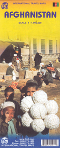
Afghanistan at 1:1, 000, 000 on a double-sided indexed map from ITMB, with large, clear street plans of central Kabul and Kandahar. Altitude colouring shows the topography and coverage extends to the North-West Frontier province of Pakistan and its Federally Administered Tribal Areas adjoining the eastern part of Afghanistan.The map clearly shows the country’s administrative divisions with names of the provinces. Elevation colouring and altitude for mountain passes are in feet (although the elevation of the Khyber Pass is given in metres). Graphics also indicate swamps and salt flats. The map shows the country’s road and rail networks, including selected 4WD tracks and trails, and marks local airports. Places of historical or geographical interest are highlighted, including the
course of the Silk Route. The map is indexed and has latitude and longitude lines at intervals of 1°. Also provided are large, clear street plans of central Kabul and Kandahar, highlighting main governmental and municipal institutions, UN offices, selected accommodation, main sights, etc.
course of the Silk Route. The map is indexed and has latitude and longitude lines at intervals of 1°. Also provided are large, clear street plans of central Kabul and Kandahar, highlighting main governmental and municipal institutions, UN offices, selected accommodation, main sights, etc.

Product Description
Reviews/Comments
Add New
Intelligent Comparison
Archived Product
Afghanistan F&B Stanfords
£10.99
Archived Product
Afghanistan Stanfords
£12.79
Archived Product
Afghanistan Stanfords
£25.00
Archived Product
Afghanistan Stanfords
£9.50
Archived Product
Pakistan ITMB Stanfords
£9.99
Archived Product
Afghanistan Wall Map Stanfords
£19.95
Archived Product
Albania ITMB Stanfords
£9.99
Vouchers
No voucher codes found.
Do you know a voucher code for this product or supplier? Add it to Insights for others to use.
Do you know a voucher code for this product or supplier? Add it to Insights for others to use.
 Denmark