
 United Kingdom
 France
 Germany
 Netherlands
 Sweden
 USA
USA
 Italy
Italy
 Spain
Spain
More From Contributor


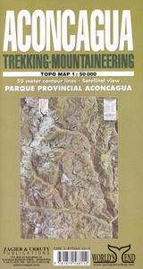
Aconcagua
Attractive, detailed topographic map covering the whole of the Aconcagua Provincial Park and its immediate surroundings: an area measuring approx. 33km east-west by 45km north-south. The map uses satellite imagery enhanced by colours as it base, with contours at 50m intervals and spot heights. The road in the valley south of the park leading to the cross-border tunnel and the trekking trails towards Aconcagua’s peak are clearly marked, with trekking times and GPS waypoints for refuges, camp sites and ranger stations. More symbols indicate mule hire, viewpoints, telephones, restaurants, first aid facilities and heliports. Latitude and longitude margin ticks are at 1’ intervals. Map legend includes English.

Product Description
Reviews/Comments
Add New
Intelligent Comparison
Archived Product
Aconcagua Stanfords
£15.99
Archived Product
Aconcagua Stanfords
£13.95
Vouchers
No voucher codes found.
Do you know a voucher code for this product or supplier? Add it to Insights for others to use.
Do you know a voucher code for this product or supplier? Add it to Insights for others to use.
 Denmark