More From Contributor

£8.99
In 2013 Assata Shakur, founding member of the Black Liberation Army, former Black Panther & godmother of Tupac Shakur, became the first ever woman to make the FBI`s most wanted terrorist list. Assata Shakur`s trial & conviction for the murder of a white state trooper in the spring of 1973 divided America. Her case quickly became emblematic of race relations & police brutality in the USA. While Assata`s detractors continue to label her a ruthless killer, her defenders cite her as the victim of a systematic, racist campaign to criminalize & suppress black nationalist organizations. This intensely personal & political autobiography reveals a sensitive & gifted woman, far from the fearsome image of her that is projected by the powers that be. With wit & candour Assata recounts the formative experiences that led her to embrace a life of activism. With pained awareness she portrays the strengths, weaknesses & eventual demise of black & white revolutionary groups at the hands of the state. A major contribution to the history of black liberation, destined to take its place alongside The Autobiography of Malcolm X & the works of Maya Angelou. ...
Archived Product
£5.50
Photoluminescent Vinyl
- 150mm x 150mm. Stanfords is an official distributor of Maritime Progress safety signs. We are able to
...
Archived Product
£17.99
Kadaster, Holland`s national survey organization, produces one of the most attractive topographic surveys in Europe. The maps are very colourful, with their characteristic patchwork of polders & an unusually large amount of land use information: meadows, arable l&, different types of forest, marshes, sand dunes, etc. Contours are shown at 5-metre intervals with numerous spot heights &, with such a large part of the country below the sea level, ”spot depths”. Each map covers an area of Approx. 25 x 20 km / 15 x 12 miles, with some sheets slightly larger. The maps have a 1-km Dutch national grid, plus latitude & longitude at intervals of 1`. Map legend

Includes::
English.IMPORTANT
- PLEASE NOTE BEFORE ORDERING: both the west (W) & the east (O) sheet of each number has the same name, although the town after which the two maps are named appears only on one of the sheets. For example: maps 41W & 41O are both called Arnhem, although the city of Arnhem appears only on sheet 40W, etc. To see the list of titles available in this series please click on the series link.


...
Archived Product
£9.50
Topographical survey of Belgium at 1:20, 000 from Nationaal Geografisch Instituut / Institut Géographique National, the country’s national survey organization. Each 20K map covers one quarter of the corresponding 1:50, 000 map (with adjustments in the border & coastal areas). The maps provide all the information expected of topographic mapping at this scale & in addition have an unusually large amount of vegetation and/or land use information (different types of woodlands, gardens, orchards, heath, etc). The maps have a 1-km UTM grid, with margin ticks for latitude & longitude at intervals of 1`. Map legend & a glossary of terms used on the maps include English. Stanfords keeps as regular stock 20K maps for the World War I battlefields around the Ypres, Messines & Passchendaele, & for the area of the Battle of Waterloo. The 1:20, 000 survey covers the whole of Belgium & maps for other regions can be supplied as special orders. To see the list of titles in this series please click on the series link.PLEASE NOTE: the Long-Distance Footpaths Map of Belgium at 1:300, 000 which shows the division of Belgium into the 50K survey sheets can also be used to see in more detail coverage by the 20K maps. ...
Archived Product
£7.95
Map No. 665, Assisi
- Camerino
- Foligno
- M. Pennino, from Kompass in a series of walking maps of selected areas of Italy


...
Archived Product
£13.99
Foligno
- Spoleto
- Terni – Valnerina area in Umbria, the Marches & Lazio on a double-sided, GPS compatible hiking & recreational

...
Archived Product
£17.99
Topographic survey of Portugal at 1:50, 000 from the Instituto Geográfico do Exército, the country’s military survey organisation. The maps have contours at 20m intervals & in addition to the standard features shown on topographic mapping at this scale also indicate various types of terrain or vegetation (s&, terraces, rocks, woodlands, vineyards, etc). Each sheet covers an area of 32 x 20km (20 x 12.5 miles approx). The maps have a 1-km UTM grid plus latitude & longitude coordinates for the map corners. Map legend & a glossary of terms used on the maps include English.EDITION DATES: most titles in this series date from 1990s or later. To see all the titles in this series please click on the series link. ...
Archived Product
£17.99
Topographic survey of Portugal at 1:50, 000 from the Instituto Geográfico Português, the country’s civilian survey organisation. The maps have contours at 25m intervals & in addition to the standard features shown on topographic mapping at this scale also indicate various types of vegetation (vineyards, olive groves, etc). Each sheet covers an area of 32 x 20km (20 x 12.5miles approx). The maps have latitude & longitude margin ticks at 1’ intervals & UTM coordinates for the map corners – each sheet also shows conversion details from BBLx (Bessel-Bonnie system, Datum Lisbon) to UTM. Map legend is in Portuguese only.EDITION DATES: most titles in this series have now been updated in the 1990s or later. To see all the titles in this series please click on the series link. ...
Archived Product
£6.39
A detailed topographic map of Assynt & Lochinver from the Ordnance Survey Explorer series, covering Kylesku & Inchnadamph. Edition A1; Publication date December 2007 About this series: These highly detailed maps show all the administrative boundaries, settlements as small as isolated farms, the road network down to unfenced roads & country tracks, & field boundaries (hedges & drystone walls) which make navigation across the countryside much easier. Steep gradients on roads are indicated. Various landmarks, e.g. powerlines, archaeological sites, windmills, churches & lighthouses are shown & additional graphics indicate natural terrain features such as cliffs, scree, mud & vegetation variations. The contour interval is 5 metres in the lower parts of the country & 10 metres in the uplands, & spot heights are marked. Each map covers an area of 30 x 20km (i.e. approx. 19 x 12 miles), with some double-sided maps covering more, as indicated in the individual descriptions. The maps are fully GPS compatible, with the National Grid shown at 1km intervals & latitude & longitude indicated by margin ticks at 1'. The Explorer series has replaced the earlier, green-cover Pathfinder maps. The Explorer series is now complete & covers all of Engl&, Wales & Scotl&. Some sheets for popular areas like the National Parks are still branded as Outdoor Leisure (OL) maps, but are now included in this series as the cartography is the same as that in the Explorer Maps. The Explorer maps offer a substantial improvement on the Pathfinder series, with greater use of colour, larger area per map, & stronger emphasis on information for ramblers & tourists. This series is ideal for walking & other outdoor pursuits & each map shows a large amount of information for ramblers & tourists. Public rights of way are shown (except in Scotland), together with other routes with public access: National Trails & Recreational Paths, permitted paths & bridleways, & selected cycle routes. Open access land created under the Countryside & Rights of Way Act 2000 is marked. Tourist information

Includes::
caravan & camp sites, Park & Ride locations, recreation/leisure/sport centres, museums, historic buildings, English Heritage & National Trust sites, rural pubs, etc. The map legend is in English only, except for the tourist information content which is also in French & German.

...
Archived Product

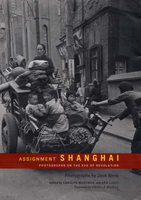
Assignment: Shanghai

Shipping out to China in December 1947 with three ten-year-old German cameras and a plum assignment from Life magazine, Jack Birns was fulfilling a boyhood dream. The reality was something else: refugees and prostitutes, soldiers and beggars, street executions and urban protests photographed in difficult and often dangerous circumstances amidst the poverty, corruption, and chaos of an expanding civil war. By then the ruling Nationalist Party had been battling the Communist threat for more than two decades, and Birns focused his camera on the human drama unfolding as war pressed ever closer to the country`s financial, cultural, and commercial capital. His effort to show China`s misery up close ran afoul of Time-Life publisher Henry R. Luce`s fervent anti-communism, and for half a
century many of these historic photographs lay unpublished in Time-Life`s archives. Printed here for the first time, they offer a graphic vision of a great city, Shanghai, poised on the precipice of political revolution.Seen through the lens of hindsight, Birns`s photographs give us a sense not only of what China was like more than fifty years ago, but also of why the warfare, weariness, and desperation of the time proved such fertile soil for communist revolution. Today these everyday scenes of ordinary people--pedicab drivers, street vendors, bar girls, police, politicians, prisoners--tell a story of national resilience and dignity in the midst of enveloping poverty, repression, and fear. Birns`s stark black and white photographs capture the dramatic end of an era, but
they also look forward, letting us glimpse how Shanghai`s past prefigures the city`s commercial and cultural revival in the 1990s.
RIP - This product is no longer available on our network. It was last seen on 25.09.2019

This page now acts as a permanent archive for this product. Add more information using the comments box below to ensure it can still be found by future generations.

Use our search facility to see if it is available from an alternative contributor.
  • Availability: Out Of Stock
  • Supplier: Stanfords
  • SKU: 9780520239906
Availability: In Stock
£22.95

Product Description

Shipping out to China in December 1947 with three ten-year-old German cameras & a plum assignment from Life magazine, Jack Birns was fulfilling a boyhood dream. The reality was something else: refugees & prostitutes, soldiers & beggars, street executions & urban protests photographed in difficult & often dangerous circumstances amidst the poverty, corruption, & chaos of an expanding civil war. By then the ruling Nationalist Party had been battling the Communist threat for more than two decades, & Birns focused his camera on the human drama unfolding as war pressed ever closer to the country`s financial, cultural, & commercial capital. His effort to show China`s misery up close ran afoul of Time-Life publisher Henry R. Luce`s fervent anti-communism, & for half a century many of these historic photographs lay unpublished in Time-Life`s archives. Printed here for the first time, they offer a graphic vision of a great city, Shanghai, poised on the precipice of political revolution. Seen through the lens of hindsight, Birns`s photographs give us a sense not only of what China was like more than fifty years ago, but also of why the warfare, weariness, & desperation of the time proved such fertile soil for communist revolution. Today these everyday scenes of ordinary people--pedicab drivers, street vendors, bar girls, police, politicians, prisoners--tell a story of national resilience & dignity in the midst of enveloping poverty, repression, & fear. Birns`s stark black & white photographs capture the dramatic end of an era, but they also look forward, letting us glimpse how Shanghai`s past prefigures the city`s commercial & cultural revival in the 1990s.

Reviews/Comments

Add New

Intelligent Comparison

Oooops!
We couldn't find anything!
Perhaps this product's unique.... Or perhaps we are still looking for comparisons!
Click to bump this page and we'll hurry up.

Price History

Vouchers

No voucher codes found.
Do you know a voucher code for this product or supplier? Add it to Insights for others to use.

Facebook

Jargon Buster

LENS - An optical element which converges or diverges light
Black - A colour which does not emit any colour of the spectrum. Black absorbs all frequencies of the spectrum.
White - A colour combining all colours
Camera - An electronic device used for taking photographs
police - Persons empowered to reduce civil disorder and enforce the law.
Human - A highly developed and adapted mamal and deminant species on earth
Year - The time it takes the planet earth to orbit the sun. This takes around 365.25 days.
Year - 365 days (366 days in a leap year), the time taken for planet earth to make one full revolution around the sun.
Vision - To be able to imagine, also can mean what you can see.

Supplier Information

Stanfords
Stanfords was established in 1853 and opened their iconic Covent Garden flagship store in 1901. They have become the top retailer of maps, travel books and accessories in the UK and arguably offer the largest selection of maps and travel books worldwide. Famous names such as Captain Robert Falcon Scott, Ranulph Fiennes and Michael Palin have purchased from Stanfords. They now have a shop in Bristol and both stores together with other venues operate a calendar of events including talks, book signings and exhibitions. As a specialist map retailer, the map selection is comprehensive and includes road maps, street maps and walking maps from worldwide destinations, as well as a selection of world atlases and wall maps. Books include travel guides and travel literature. Stanfords also stock globes, from miniatures made of blue marble to magnificent floor-standing globes. The website features a selection of interesting articles on travel topics.
Page Updated: 2023-11-12 20:15:36

Community Generated Product Tags

Oh No! The productWIKI community hasn't generated any tags for this product yet!
Menu