More From Contributor
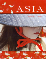
£3.50
Ashton upon Mersey in 1908 in a fascinating series of reproductions of old Ordnance Survey plans in the Alan Godfrey Editions, ideal for anyone interested in the history of their neighbourhood or family. The map covers much of Ashton upon Mersey, extending from Park Road & Washway Road westward to the parish boundary, & from Ashton New Hall southward to Woodheys Farm & Hesketh Road. Features include tramway, Oaklee Farm, St Mary Madgalene church, Macum Farm, graveyard of St Martin`s church (church itself just off to the north), Ivy Farm, Ingestre, Green Lane area, Ashton Lane, Moss Lane, etc. On the reverse are extracts from a 1906 street directory for Barker`s Lane, Beech Grove, Carlton Road, Green Lane, Harboro` Road, Moss Lane & Urban Road. About the Alan Godfrey Editions of the 25” OS Series: Selected towns in Great Britain & Ireland are covered by maps showing the extent of urban development in the last decades of the 19th & early 20th century. The plans have been taken from the Ordnance Survey mapping & reprinted at about 15 inches to one mile (1:4, 340). On the reverse most maps have historical notes & many also include extracts from contemporary directories. Most maps cover about one mile (1.6kms) north/south, one & a half miles (2.4kms) across; adjoining sheets can be combined to provide wider coverage.FOR MORE INFORMATION & A COMPLETE LIST OF ALL AVAILABLE TITLES PLEASE CLICK ON THE SERIES LINK. ...
Archived Product
£2.95
Ashton-on-Mersey in 1927 in a fascinating series of reproductions of old Ordnance Survey plans in the Alan Godfrey Editions, ideal for anyone interested in the history of their neighbourhood or family. Selected towns in Great Britain & Ireland are covered by maps showing the extent of urban development in the last decades of the 19th & early 20th century. In this title: although this map is in the Lancashire series, most of the coverage is actually of Cheshire. The map covers a busy area of Sale & Ashton-on-Mersey, with Washway Road & Cross Street (part shown as an old Roman Road) as the boundary. Coverage stretches from Harboro Road West & Ashton New Hall eastward to Priory Road & Winstanley Road, & from Northenden Road & Charlton Drive northward to the Ousel Brook. North of the Mersey the only feature is a sewage Farm. Within Sale the many features include Sale Town Hall, Sale & Dane Road stations, School Road, Bridgewater Canal & wharf, Broad Road, Tatton Road etc; within Ashton features include Ashton Lane, picture theatres, Friends Meeting House & burial ground, Grosvenor Road, Ashton Park, St Martin's church, Ashton Hall Farm, Rivershill, Mersey Market Garden etc. Several extracts from a 1906 street directory are on the reverse, including entries for Ashton Lane, Broad Road, Cross Street, Mersey Road, Tatton Road. About the Alan Godfrey Editions of the 25 ...
Archived Product
£3.50
Ashton-on-Mersey in 1927 in a fascinating series of reproductions of old Ordnance Survey plans in the Alan Godfrey Editions, ideal for anyone interested in the history of their neighbourhood or family. Although this map is in the Lancashire series, most of the coverage is actually of Cheshire. The map covers a busy area of Sale & Ashton-on-Mersey, with Washway Road & Cross Street (part shown as an old Roman Road) as the boundary. Coverage stretches from Harboro Road West & Ashton New Hall eastward to Priory Road & Winstanley Road, & from Northenden Road & Charlton Drive northward to the Ousel Brook. North of the Mersey the only feature is a sewage Farm. Within Sale features include Sale Town Hall, Sale & Dane Road stations, School Road, Bridgewater Canal & wharf, Broad Road, Tatton Road, etc; within Ashton features include Ashton Lane, picture theatres, Friends Meeting House & burial ground, Grosvenor Road, Ashton Park, St Martin`s church, Ashton Hall Farm, Rivershill, Mersey Market Garden, etc. Several extracts from a 1906 street directory are on the reverse, including entries for Ashton Lane, Broad Road, Cross Street, Mersey Road & Tatton Road. About the Alan Godfrey Editions of the 25” OS Series: Selected towns in Great Britain & Ireland are covered by maps showing the extent of urban development in the last decades of the 19th & early 20th century. The plans have been taken from the Ordnance Survey mapping & reprinted at about 15 inches to one mile (1:4, 340). On the reverse most maps have historical notes & many also include extracts from contemporary directories. Most maps cover about one mile (1.6kms) north/south, one & a half miles (2.4kms) across; adjoining sheets can be combined to provide wider coverage.FOR MORE INFORMATION & A COMPLETE LIST OF ALL AVAILABLE TITLES PLEASE CLICK ON THE SERIES LINK. ...
Archived Product
£2.95
Ashton-under-Lyne in 1916 in a fascinating series of reproductions of old Ordnance Survey plans in the Alan Godfrey Editions, ideal for anyone interested in the history of their neighbourhood or family. Selected towns in Great Britain & Ireland are covered by maps showing the extent of urban development in the last decades of the 19th & early 20th century. In this title: the map covers the central & western parts of Ashton, stretching from Old Square westward to Ashton Moss, & from Christ Church & Lord Street southward to Ryecroft Street. Mills include Ryecroft Mills, Fern Mill, Junction Mills, Tudor Mill, Cavendish Mill etc. The town is surrounded by railways & the map shows Charlestown, Park Parade, & Oldham Road station; a small part of Dukinfield is also included & there are two stations here. Other features include tramways, canals including Portland Basin, Henry Square with the magnificent Public Baths, National Gas Engine Works, St Peter's church. A list of private residents from a 1918 directory is included. About the Alan Godfrey Editions of the 25 ...
Archived Product
£3.50
Ashton-under-Lyne in 1916 in a fascinating series of reproductions of old Ordnance Survey plans in the Alan Godfrey Editions, ideal for anyone interested in the history of their neighbourhood or family. The map covers the central & western parts of Ashton, stretching from Old Square westward to Ashton Moss, & from Christ Church & Lord Street southward to Ryecroft Street. Mills include Ryecroft Mills, Fern Mill, Junction Mills, Tudor Mill, Cavendish Mill, etc. The town is surrounded by railways & the map shows Charlestown, Park Parade, & Oldham Road station; a small part of Dukinfield is also included & there are two stations here. Other features include tramways, canals including Portland Basin, Henry Square with the magnificent Public Baths, National Gas Engine Works, St Peter`s church, etc. A list of private residents from a 1918 directory is on the reverse. About the Alan Godfrey Editions of the 25” OS Series: Selected towns in Great Britain & Ireland are covered by maps showing the extent of urban development in the last decades of the 19th & early 20th century. The plans have been taken from the Ordnance Survey mapping & reprinted at about 15 inches to one mile (1:4, 340). On the reverse most maps have historical notes & many also include extracts from contemporary directories. Most maps cover about one mile (1.6kms) north/south, one & a half miles (2.4kms) across; adjoining sheets can be combined to provide wider coverage.FOR MORE INFORMATION & A COMPLETE LIST OF ALL AVAILABLE TITLES PLEASE CLICK ON THE SERIES LINK. ...
Archived Product
£4.99
A double sided map of Asia to the scale of 1:15, 625, 000. One side of the map is Asia-Political, the other Asia-Physical. Both sides of the map also show border areas of surrounding continents. The Asia-Political map shows lines of latitude & longitude & has some shading relief for major mountain ranges. National flags & details basic information about each country ...
Archived Product
£5.59
Asia & India in the Healthy Travel series from Lonely Planet; comprising a range of handy, pocket-sized guides aimed at minimising health risks for those travelling through high-risk countries & regions. Compiled by a travel health expert, the guide provides practical advice on pre-trip planning (including immunisations), staying healthy while on the road & what to do if you run into problems. The pocket-sized format allows each guide to be used while travelling or alternatively as a useful reference guide from home. Widely recognised for the level of detail included, the Healthy Travel Lonely Planet guides each have the same format, with regional variations to take account of particular local risks. Opening chapters provide detailed advice on pre-trip planning, pre-travel health checks, what to take, books & travel health insurance. Further sections also provide tips on staying healthy on the road & how to get medical help when away. Individual sections are thematically arranged for ease of reference, with individual chapters on Fever & Hepatitis, the Digestive System, Respiratory System, Eyes, Ears & teeth, Skin, HIV/AIDS & Mental Health. Tailored advice is also provided for different groups, including men & women travellers, babies & children & travellers with special needs. There are also dedicated sections to the local climate, altitude, water & bites & stings. A handy ...
Archived Product
£8.95
Attractive political map with bathymetric tinting to give an impression of ocean depth. The coverge extends from Kazakhstan, Lake Baikal & the southern tip of Kamchatka in the north to the Kerguelen Islands & New Zealand in the south. Longitude range is from 60 ...
Archived Product
£19.95
Asia beyond Growth is a visual study of urbanization in the world’s fastest changing continent. Full of photographs & hard hitting stats & data the book addresses the challenges posed by the ever burgeoning cities across Asia. The difficulties
- population explosion, destruction of eco-systems, water shortages, sanitation, & inhuman social environments
- are presented but so to are some solutions that have been provided by visionary architects, designers & planners.

...
Archived Product
£16.99
Asia on a high quality, double-sided wall map, size 85 x 115cm (35.5” x 45” approx), from Columbus Globes presenting on one side a political map & on the reverse a physical image. Unlike on most maps of Asia, coverage extends beyond the North Pole to provide a fuller picture of the Arctic Region. Most of Europe is included; the island of New Guinea is shown as an inset. All place names are in English. On one side is a political map of Asia in light, bright colours, with international boundaries enhanced by darker colouring. Relief shading shows the topography not only on land but also of the sea floor, & the map has plenty of names of mountain ranges, plateaux, peaks, deserts, etc. No information on road or railway networks is included. On the reverse is a physical map with the same projection & coverage. The map carries the same information as the political map but with colours for individual countries replaced by altitude colouring. On both sides latitude & longitude lines are drawn at 5° intervals. The map is printed on high quality glossy paper with bright shining surface. ...
Archived Product

Asia

Asia is the fourth in the successful Abrams series of photographs by renowned photographer Olivier Follmi, following in the footsteps of his works on India, Africa and Latin America. Inspired by the beauty of distant countries, Asia celebrates the depth and grandeur of the far-east. This work presents the most exceptional images the artist took during his travels in Burma, Japan, China, Vietnam and many points between. The large format allows the photographs, their colours and the places and people they capture to come alive in the reader`s hands. The photographs are accompanied by captions that give detailed information about each image, which have been written by acclaimed journalist Virginie de Borchgrave. The book also includes an introduction by Francois and an essay by
Follmi, who describes his experience travelling in these regions. Asia is a celebration and invocation of the continent that not all are fortunate enough to visit, but which has inspired many to dream.
RIP - This product is no longer available on our network. It was last seen on 25.09.2019

This page now acts as a permanent archive for this product. Add more information using the comments box below to ensure it can still be found by future generations.

Use our search facility to see if it is available from an alternative contributor.
  • External links may include paid for promotion
  • Availability: Out Of Stock
  • Supplier: Stanfords
  • SKU: 9780810971219
Availability: In Stock
£29.99

Product Description

Asia is the fourth in the successful Abrams series of photographs by renowned photographer Olivier Follmi, following in the footsteps of his works on India, Africa & Latin America. Inspired by the beauty of distant countries, Asia celebrates the depth & grandeur of the far-east. This work presents the most exceptional images the artist took during his travels in Burma, Japan, China, Vietnam & many points between. The large format allows the photographs, their colours & the places & people they capture to come alive in the reader`s hands. The photographs are accompanied by captions that give detailed information about each image, which have been written by acclaimed journalist Virginie de Borchgrave. The book also

Includes::
an introduction by Francois & an essay by Follmi, who describes his experience travelling in these regions. Asia is a celebration & invocation of the continent that not all are fortunate enough to visit, but which has inspired many to dream.

Reviews/Comments

Add New

Price History

Vouchers

No voucher codes found.
Do you know a voucher code for this product or supplier? Add it to Insights for others to use.

Facebook

Jargon Buster

Japan - An island in east Asia
India - A subcontinent in Asia
Large - something that takes up more space than normal.
Exceptional - Something that is very good.
Experience - To gain further knowledge by practising.

Supplier Information

Stanfords
Stanfords was established in 1853 and opened their iconic Covent Garden flagship store in 1901. They have become the top retailer of maps, travel books and accessories in the UK and arguably offer the largest selection of maps and travel books worldwide. Famous names such as Captain Robert Falcon Scott, Ranulph Fiennes and Michael Palin have purchased from Stanfords. They now have a shop in Bristol and both stores together with other venues operate a calendar of events including talks, book signings and exhibitions. As a specialist map retailer, the map selection is comprehensive and includes road maps, street maps and walking maps from worldwide destinations, as well as a selection of world atlases and wall maps. Books include travel guides and travel literature. Stanfords also stock globes, from miniatures made of blue marble to magnificent floor-standing globes. The website features a selection of interesting articles on travel topics.
Page Updated: 2023-11-12 20:15:36

Community Generated Product Tags

Oh No! The productWIKI community hasn't generated any tags for this product yet!
Menu