More From Contributor

£11.50
Armenia at 1:250, 000 on an indexed, waterproof & tear-resistant road map with topographic & tourist information, published by Reise Know-How as part of their highly acclaimed World Mapping Project. The map is double-sided to provide the best balance between a good scale & a convenient size sheet; Yerevan & the southern part of the Sevan Lake are included on both sides. The southern side of the map indicates the disputed borders of Nagorno Karabakh & also covers the whole of the southern part of Azerbaijan between Armenia & Turkey. Along Armenia’s eastern border with Azerbaijan enclaves on both sides are clearly marked. Names of larger towns & selected smaller locations, & names of the provinces are also shown in the Armenian alphabet – all other place names are in the Latin alphabet only. Road & rail networks are easy to see on a clear base which shows the country’s topography by altitude colouring with contours, spot heights, mountain passes, & names of mountain ranges. National parks & other protected areas are marked. Road network

Includes::
minor local roads, indicates border crossings, & shows intermediate driving distances on main & on selected secondary roads. Railway lines are included & local airports are marked. Symbols highlight various places of interest including UNESCO World Heritage sites, castle & monasteries, archaeological sites & rock paintings, winter sport locations, etc. The map has a latitude/longitude grid at intervals of 15’ & an index of localities. Map legend

Includes::
English.


...
Archived Product
£14.99
This rural retreat enjoys an astonishingly well-preserved legacy of monastic buildings, often set in magnificent locations. Nicholas Holding covers a wide spectrum of activities that give Armenia a huge potential for visitors, including birding, hiking, the arts, architectural tours, botanical trips, angling, horseriding & caving. ...
Archived Product
£16.99
Armenia with Nagorno Karabagh in the Travel Guide series from Bradt; encompassing a comprehensive range of titles to destinations worldwide, with a particular focus on Africa, Central & South America. Bradt are one of the country’s leading independent publishers & have an ethos that focuses on responsible travel, in alliance with a philosophy of sustainability; both in the destinations the guides cover but also in encouraging tourists to limit the impact they have on the local environment. Bradt guides have a reputation for appealing to more independent travelers & often cover destinations that are not available from other publishers. Each guide opens with two comprehensive chapters on Background & Practical Information, covering details of the country’s geography, culture, natural history, government & politics, economy, people, language, religion, education & culture. Important practical advice

Includes::
when to visit, highlights, suggested itineraries, tour operators, red tape, embassies & consulates, getting there & away, health, safety, what to take, money, budgeting, getting around, accommodation, eating & drinking, public holidays, shopping, arts & entertainment, media & communications, business, travel culture & cultural etiquette. Individual sections are organized geographically by region & typically open with information on practicalities & orientation, before focusing on what to see & where to go. Information on what to see, where to stay, where to eat & how to find your way around is provided, with a range of budgets catered for. Simple black & white maps locate key visitor sites & places of accommodation. Bradt Travel Guides include appendices that provide an in-depth introduction to the language of each country, a glossary of terms & a listing of books & internet resources providing further information on the destination. Ed. 4th, September 2014.

...
Archived Product
£12.00
Few writers had to confront so many of the last century`s mass tragedies as Vasily Grossman. He is likely to be remembered, above all, for the terrifying clarity with which he writes about the Shoah, the Battle of Stalingrad & the Terror Famine in the Ukraine. An Armenian Sketchbook, however, shows us a very different Grossman; it is notable for its warmth, its sense of fun & for the benign humility that is always to be found in his writing. After the `arrest`
- as Grossman always put it
- of Life & Fate, Grossman took on the task of editing a literal Russian translation of a lengthy Armenian novel. The novel was of little interest to him, but he was glad of an excuse to travel to Armenia. This is his account of the two months he spent there. It is by far the most personal & intimate of Grossman`s works, with an air of absolute spontaneity, as though Grossman is simply chatting to the reader about his impressions of Armenia
- its mountains, its ancient churches & its people.


...
Archived Product
£11.50
Map No. 2404E, Armentières, in IGN’s excellent, detailed topographic survey of France at 1:25, 000. Centred on Armentières, the town of the ” Mademoiselle from Armentières”
- the song also known by its line ” Hinky Dinky Parley Voo”, the map covers part of the WWI Western Front on the border of France & Flanders. Coverage within France extends south to the Aubers Ridge, west to Laventie & Steenwerck, & east to include Frelinghien & Houplines. Within Flanders coverage

Includes::
Ploegsteert (Plugstreet), Nieuwkerke & Warneton/ Waasten. Although not specifically designed to show WWI memorial sites & best used in conjunctions with one of the specialist maps of the Western Front, maps in the IGN 1:25, 000 series are ideal for locating access to the numerous smaller war cemeteries & memorials scattered across Picardy. Please note: unlike within France, cemeteries on the Belgian side of the border are not annotated to indicate the nationality of the soldiers buried there. The map is contoured, GPS compatible & shows all the features expected of topographic mapping at this scale. Map legend is in French only. To see the full description of IGN’s 1:25, 000 topographic survey of France & the list of all the titles in this series please click on the series link.


...
Archived Product
£14.99
Arnarfjörður, map no. 6, in the topographic survey of Iceland at 1:100, 000 published by Mál og menning, with excellent, vivid presentation of the terrain, footpaths & bridleways, campsites, etc. The maps have contours at 20m intervals, enhanced by bold relief shading plus colouring and/or graphics to show glaciers, lava fields, sands & mudflats, as well as to distinguish land with vegetation cover from the more sparsely covered terrain. The series provides a splendid presentation of the country’s topography, with large amount of detail & over 43, 000 place names. Road network indicates gravel roads &

Includes::
country tracks. Also marked are local footpaths, clear to see with their distinctive colouring, & bridleways. Symbols shows campsites, tourist huts or shelters, emergency shelters, summer houses, river fords, golf courses & swimming pools, hydro-electric or thermal power stations, local airports, etc, & detail such as individual farms, abandoned farms or ruins, sheepfolds, etc. Each map covers an area of 84 x 67km (53 x 42 miles approx.) & has latitude & longitude lines drawn at intervals of 2’ & 5’ respectively. Map legend

Includes::
English, German & French. To see the other titles in this series please click on the series link.


...
Archived Product
£12.99
Topographic survey of France at 1:25, 000 in IGN`s excellent TOP25 / Série Bleue series. All the maps are GPS compatible, with a 1km UTM grid plus latitude & longitude lines at 5’ intervals. Contours are at 5m intervals except for mountainous areas where the maps have contours at 10m intervals, vividly enhanced by hill shading & graphics for rocky terrain. Colouring with graphics indicates different types of vegetation or land use (deciduous or coniferous forests, moors, orchards, vineyards, etc). PLEASE NOTE: coverage of France at this scale is currently being revised – the format & the presentation of each title are indicated by the letters at the end of its Sheet Reference number (e.g. 0416ET, 3531ETR, 1923SB, etc.)MAPS WITH FULL TOURIST OVERPRINT & AN ENGLISH MAP LEGEND: all TOP25 maps & the SB editions of Série Bleue have an overprint highlighting waymarked walking trails including long-distance GR routes &, where appropriate, ski routes. Symbols indicate campsites, gîtes d’etape, refuges, equestrian centres & other recreational facilities or sites, tourist information centres, cultural heritage, etc. Towns & locations of particular interest are highlighted.- ET or OT = single-sided TOP25 map covering approx. 29x 21 km / 18x 13 miles.- ETR or OTR = waterproof & tear resistant TOP25 map covering the same area as the corresponding ET or OT number, but double-sided, printed on a smaller size sheet with a good overlap between the sides.- SB = Série Bleue map with full tourist overprint; these maps, first introduced in summer 2014, each cover approx. 29x 24km / 18x 15 miles.SÉRIE BLEUE maps with numbers ending in E (Est) or O (Ouest): most editions now indicate the GR routes, but do not show any other tourist information. Map legend is in French only. Each map covers approx. 14x 20km / 9x 12 miles. ...
Archived Product
£6.95
Topographic coverage of mainland Spain at 1:50, 000 in the MTN50 (Mapa Topográfico Nacional) series from the Centro Nacional de Información Geografica, the country’s civilian survey organization. The maps have contours at 20m intervals, enhanced by relief shading, plus colouring and/or graphics to show different types of terrain, vegetation or land use. Boundaries of national parks & other protected areas are marked. In addition to all the usual information featured on topographic mapping at this scale, detailed presentation of the road & rail networks, rural tracks & paths, etc, the maps also show campsites & mountain refuges. On more recent editions some GRs, the official long-distance hiking routes, are also marked (although not as clearly as on hiking maps from other publishers). Each map covers 29.5x 18.5 km (with adjustments in the border or coastal areas). The maps have a 1-km UTM grid, plus margin ticks for latitude & longitude at 1` intervals. Map legend is in Spanish only.HOW TO CHOOSE THE RIGHT 50K MAP: all the titles in CNIG’s 200K Provincial Road Maps series at 1:200, 000 are overprinted with the grid for the 1:50, 000 maps & can be used to see the area covered by each 50K title. TO SEE THE LIST OF TITLES IN THIS SERIES PLEASE CLICK ON THE SERIES LINK.PLEASE NOTE
- MAP TITLES: the grids shown on our website serve both the civilian & the military 1:50, 000 topographic series. Although the areas covered by maps in both series are identical (apart from some border or coastal sheets), occasionally map titles differ – only one title is shown on the grid, usually the military one. In Galicia, the Basque country & in the Catalan speaking areas the tendency now is to use local place names rather than the often better known Castilian ones. Where possible, both versions are included in our titles. Map titles listed on our website are based on information received by us at the time of publication, but sometimes maps arrive showing a completely different title! As long as the map number is as ordered, the correct map has been supplied.
...
Archived Product
£6.50
Arnhem on an indexed street plan at 1:12, 500 from Falk NV, with an enlargement showing the city centre in greater detail, plus lists public transport lines, official organizations, etc. Coverage, extended by panels on the reverse,

Includes::
Duiven, Elst, Groessen, Huissen, Loo, Oosterbeek, Rozendaal, Velp & Westervoort. Colouring indicates different types of land use (public buildings, greenhouses, industrial areas, parks, etc). One way or restricted entry streets & car parks are marked. Symbols indicate various facilities including campsites. Map legend

Includes::
English. The lists with information about transport lines, municipal offices, cultural & sport facilities, etc, are in Dutch only.


...
Archived Product
£7.99
The Arnhem – Nijmegen area of eastern Netherlands at 1:50, 000 in a series from Falk B.V. showing the network of signposted cycling routes on large, double-sided indexed maps with prominent highlighting of long-distance LF routes, symbols indicating accommodation & other tourist services, plus in each title two or more panels with recommended local circuits & additional tourist information. The map covers the area from in the north Otterloo in the Hoge Veluwe National Park (and with its Van Gogh Kröller-Müller Museum one of the most visited locations in the Netherlands) to Cuik south of Nijmegen & Kleve in Germany. On the reverse seven special panels show recommended cycling circuits including a Liberation Route along the sites of the Market Garden landings in WWII. Cartography of this special sheet is the same as used by the publishers in the rest of the series, but without indicating cycle rental points & with additional information for hikers. To see the full description of Falk’s 50K cycling series (which also

Includes::
Flanders & some adjoining areas in Lower Saxony) as well as the list of all currently available titles please click on the series link.

...
Archived Product

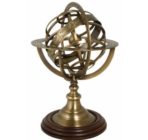
Armillary Sphere Large

The armillary sphere shows the Earth (a central ball) surrounded by rings (armilla in Latin) which represent the great circles of the heavens. It was widely used during the 17th and 18th centuries in scientific debates over the relative merits of the competing central Earth and central Sun theories. Our simplified, decorative brass version makes a handsome ornament for the desk or garden.Stands approximately 12” high, made from solid machined brass with an antique finish and polished wooden base.
RIP - This product is no longer available on our network. It was last seen on 25.09.2019

This page now acts as a permanent archive for this product. Add more information using the comments box below to ensure it can still be found by future generations.

Use our search facility to see if it is available from an alternative contributor.
  • External links may include paid for promotion
  • Availability: Out Of Stock
  • Supplier: Stanfords
  • SKU: 5024700729813
Availability: In Stock
£110.00

Product Description

The armillary sphere shows the Earth (a central ball) surrounded by rings (armilla in Latin) which represent the great circles of the heavens. It was widely used during the 17th & 18th centuries in scientific debates over the relative merits of the competing central Earth & central Sun theories. Our simplified, decorative brass version makes a handsome ornament for the desk or garden. Stands Approx. 12” high, made from solid machined brass with an antique finish & polished wooden base.

Reviews/Comments

Add New

Intelligent Comparison

Oooops!
We couldn't find anything!
Perhaps this product's unique.... Or perhaps we are still looking for comparisons!
Click to bump this page and we'll hurry up.

Price History

Vouchers

No voucher codes found.
Do you know a voucher code for this product or supplier? Add it to Insights for others to use.

Facebook

Jargon Buster

Brass - A copper and Zinc Alloy
Garden - An outside area with grass and foliage
Wooden - Something that is made from wood, from trees
antique - An old collectible item with desirable qualities.
garden - A planned space used for the display, cultivation and enjoyment of plants and other forms of nature.
sun - A star at the centre of the solar system.
Desk - A piece of furniture often used in and office for writing or computer use
Ornament - A decorative item for displaying in the home or garden
polished - A process that makes and object or surface shiny. A refined and flawless finish.
Earth - A planet third from the sun. Similar size to Venus but rich in water and complex life.
Large - something that takes up more space than normal.
Solid - Something that is firm and not liquid, a hard shape that cannot be changed easily.
Decorative - Making things look more appealing and attractive.

Supplier Information

Stanfords
Stanfords was established in 1853 and opened their iconic Covent Garden flagship store in 1901. They have become the top retailer of maps, travel books and accessories in the UK and arguably offer the largest selection of maps and travel books worldwide. Famous names such as Captain Robert Falcon Scott, Ranulph Fiennes and Michael Palin have purchased from Stanfords. They now have a shop in Bristol and both stores together with other venues operate a calendar of events including talks, book signings and exhibitions. As a specialist map retailer, the map selection is comprehensive and includes road maps, street maps and walking maps from worldwide destinations, as well as a selection of world atlases and wall maps. Books include travel guides and travel literature. Stanfords also stock globes, from miniatures made of blue marble to magnificent floor-standing globes. The website features a selection of interesting articles on travel topics.
Page Updated: 2023-11-12 20:15:36

Community Generated Product Tags

Oh No! The productWIKI community hasn't generated any tags for this product yet!
Menu