More From Contributor
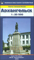
£22.99
Arkansas Recreational Atlas & Gazetteer at 1:125, 000 approx. from De Lorme in a new edition published in 2011, with GPS compatible mapping & extensive additional recreational information including facilities at campgrounds, etc. Each title in this De Lorme series covers one state & presents it at a scale much more detailed than used on most state road maps. Particularly popular areas are often also presented on enlargements. The maps are contoured, show variation of terrain (deserts, glaciers, wetlands, woodlands, etc) & have latitude & longitude and/or UTM grid lines for GPS use. Various types of protected areas are distinguished by the colouring of their boundaries, e.g. national or state parks, forests, etc. Also marked are Indian Reservations & restricted entry military zones. Road network is shown in much more detail than on other state mapping, with local roads, unsurfaced back roads & tracks, forest trails, etc. Where appropriate, old historical routes are marked. Railway lines & local airports or landing strips are included & the maps also indicate administrative boundaries. Symbols highlight various recreational areas & facilities such as campgrounds, unique natural features, etc. Each title contains extensive lists of outdoor adventure sites (grouped into activities such as hiking, biking, paddling, fishing, skiing, etc.), diverse family outing sites, campgrounds, & tables showing what facilities can be found in the state’s recreational areas. Each atlas also has an index of localities. To see the list of titles in this series please click on the series link. ...
Archived Product
£12.99
• Waterproof • Tear-Resistant • Fishing & River Map The Arkansas River, Leadville to Salida Fishing & River Map Guide is designed to be the perfect companion to anyone recreating on the upper Arkansas. On the upper river, there is a great distinction to be drawn between the waters above & below the confluence with Lake Creek. This is partly one of topography—above this point the river is largely an oxbowed meadow stream, while below it flows through the steep & confined channel of the Granite Gorge & on through the several canyons that follow. But it is also differentiated by its hydrology—the flow through the Hayden Meadows reach above Lake Creek is almost totally natural, with a short but intense spring runoff, while the river below that confluence is augmented by releases of water from both Twin Lakes & Turquoise reservoirs. As a result of these impoundments, higher flows are common below Lake Creek in general & throughout the summer in particular. Each Fishing & River Map Guide

Includes::
detailed river maps at a scale of 1 inch = 1/2 mile. At this scale every turn in the river & rapid is clearly shown & labeled. Each page is centered on the river & overlaps with the adjacent pages so finding any location along the river is easy. The maps include rapids, river miles, access points, private & public lands, gaging stations, recreation sites, & more. Greg Felt, a renowned fly fishing guide on the Arkansas River, has written the introduction as well as descriptions of specific fly fishing strategies & seasonal fluctuations found on the river. Also included are stream flow charts, hatch charts, & a table of river access points. More convenient & easier to use than folded maps, but just as compact & lightweight, National Geographic`s Fishing & River Map Guide booklets are printed on ” Backcountry Tough” waterproof, tear-resistant paper with stainless steel staples. A full UTM grid is printed on the map to aid with GPS navigation.

...
Archived Product
£12.99
• Waterproof • Tear-Resistant • Fishing & River Map The Arkansas River, Salida to Cañon City Fishing & River Map Guide is designed to be the perfect companion to anyone recreating on this section of the Arkansas. From Salida to Cañon City, the Arkansas River cuts east through a series of high desert canyons collectively known as Bighorn Sheep Canyon & the Royal Gorge. Along the way, it covers 56 river miles & drops 1, 700 feet in elevation. The geology of this reach varies greatly, with canyons confining the channel from Salida to Howard, Coaldale to Lone Pine, & Texas Creek to Parkdale. Between these, the terrain opens up, with the river typically becoming broader & the current velocity less. The final stretch, the Royal Gorge, is a Class IV+ chasm that is only accessible by boat & is not known for its fishing. Each Fishing & River Map Guide

Includes::
detailed river maps at a scale of 1 inch = 1/2 mile. At this scale every turn in the river & rapid is clearly shown & labeled. Each page is centered on the river & overlaps with the adjacent pages so finding any location along the river is easy. The maps include rapids, river miles, access points, private & public lands, gaging stations, recreation sites, & more. Greg Felt, a renowned fly fishing guide on the Arkansas River, has written the introduction as well as descriptions of specific fly fishing strategies & seasonal fluctuations found on the river. Also included are stream flow charts, hatch charts, & a table of river access points. More convenient & easier to use than folded maps, but just as compact & lightweight, National Geographic`s Fishing & River Map Guide booklets are printed on ” Backcountry Tough” waterproof, tear-resistant paper with stainless steel staples. A full UTM grid is printed on the map to aid with GPS navigation.

...
Archived Product
£30.00
Detailed physical wall map of Arkansas State at a scale of 1:500, 000. The cartography shows relief through a stunning, highly ...
Archived Product
£9.95
West Arkansas Cities in a series of City Map Books from Rand Mc Nally providing in a handy 10.5 x 24 cm paperback format a collection of street plans for neighbouring towns & cities within a region. Areas covered by the plans are shown on a regional map & all the plans covered by one overall street index. The plans show the network of streets & roads, indicating where appropriate, routes with limited access, tolls, service & rest areas, one-way traffic, etc. Railway & local transit stations are marked & a range of symbols indicate various services & places of interest. This title provides coverage of Bentonville, Fayetteville, Fort Smith, Rogers, Russellville, Springdale & Texarkana. ...
Archived Product
£6.95
Arkhyz area at 1:100, 000 in a series of detailed topographic survey maps of the Western Caucasus from the Russian Army Cartographic Units in Rostov-na-Donu, with all place names in the Cyrillic alphabet. All the maps are contoured, with peak heights & colouring/graphics for rocky outcrops, snow covered or exposed ice fields, glaciers, forested areas, etc. The maps show local roads, cart tracks & footpaths, as well as other information usually found on topographic survey maps at this scale: settlements & individual buildings, bridges, electricity transmission lines, etc. Most titles have geographical coordinates, as indicated in the individual descriptions. All place names are in the Cyrillic alphabet. Some titles also include additional street plans and/or other information for climbers: a table showing the chill factor for various combinations of temperature & wind speed, international codes for conveying information to mountain rescue services, & drawings with advice on basic first aid.* Map legend & all the text are in Russian only.** In this title:* contours are at 40m intervals. No geographical coordinates are shown. On the reverse is a table showing the chill factor for various combinations of temperature & wind speed, international codes for conveying information to mountain rescue services, & drawings with advice on basic first aid.* *IMPORTANT
- PLEASE NOTE: deliveries from Russia are highly irregular & we are unable to guarantee delivery dates for maps or atlases which are not currently in stock.*
...
Archived Product
£9.99
Greek islands of Arki (Arkoi), Lipsi & Aghathonisi on a light, waterproof & tear-resistant, contoured & GPS compatible map at 1:20, 000 from Terrain Editions. On the reverse are notes about the three islands, illustrated with colour photos. All place names are shown in both Greek & Latin alphabet. Map legend & all the text include English. Maps of the Greek islands from Terrain Editions have topography well presented by contours at 20m intervals (unless indicated differently in the map`s individual description), enhanced by spot heights, subtle relief shading & additional altitude colouring. Road network is very clearly graded according to width & the type of surface, distinguishing between good & rough dirt roads. Distances are marked on most small local roads, as well as locations of petrol stations and/or tyre repair workshops; scenic routes are highlighted. Each map also shows which ports are served by ferry services. Hiking paths are graded as main or narrow trails. National parks & other protected areas are marked & a wide range of symbols indicate various places of interest & recreational facilities, with main sights clearly highlighted. Most titles distinguish between sandy & pebble beaches; some also indicate beaches with natural shade and/or the type of sea bed. The maps have a UTM grid, plus latitude & longitude margin ticks. The reverse side of each title is covered by general information about the isl&, illustrated with colour photos. Many titles also include brief descriptions of recommended hiking trails and/or a street plan of the island’s main town, with colouring clearly showing various tourist facilities. To see the other titles in this series please click on the series link. ...
Archived Product
£13.99
This map of Arkosund Gryt Vastervik in 1:50, 000 is part of a series of topographic maps from Norstedts Kartforlaget which


...
Archived Product
£16.99
Sverigeserien is an outdoor map series consisting of 116 sheets with coverage of southern & central Sweden & the northern coastline. The map is suitable for outdoor activities such as hiking, excursions, trail running, hunting, fishing, riding, cycling, mountain biking, paddling, skating & much more. Every sheet covers an area of 45x 68km. These topographical maps in scale 1:50 000 contain all the information needed for outdoor activities: Terrain information, hiking trails, illuminated tracks, camping, shelters, golf courses, leisure baths, historical remains, roads in different categories, railway lines & much more. Easy to read topography with contour lines, vertical interval 5 m. Sverigeserien is a high-quality map series & is durable for frequent use! Updated content with map data from Lantmäteriet (National Land Survey of Sweden) & printed on Polyart which is water & tear resistant. This means that the map can be folded repeatedly without breaking & can withstand the challenging weather in Sweden during both winter & summer. Legend is in Swedish, English & German. ...
Archived Product
£11.50
Topographic survey of France at 1:25, 000 in IGN`s excellent TOP25 / Série Bleue series. All the maps are GPS compatible, with a 1km UTM grid plus latitude & longitude lines at 5’ intervals. Contours are at 5m intervals except for mountainous areas where the maps have contours at 10m intervals, vividly enhanced by hill shading & graphics for rocky terrain. Colouring with graphics indicates different types of vegetation or land use (deciduous or coniferous forests, moors, orchards, vineyards, etc). PLEASE NOTE: coverage of France at this scale is currently being revised – the format & the presentation of each title are indicated by the letters at the end of its Sheet Reference number (e.g. 0416ET, 3531ETR, 1923SB, etc.)MAPS WITH FULL TOURIST OVERPRINT & AN ENGLISH MAP LEGEND: all TOP25 maps & the SB editions of Série Bleue have an overprint highlighting waymarked walking trails including long-distance GR routes &, where appropriate, ski routes. Symbols indicate campsites, gîtes d’etape, refuges, equestrian centres & other recreational facilities or sites, tourist information centres, cultural heritage, etc. Towns & locations of particular interest are highlighted.- ET or OT = single-sided TOP25 map covering approx. 29x 21 km / 18x 13 miles.- ETR or OTR = waterproof & tear resistant TOP25 map covering the same area as the corresponding ET or OT number, but double-sided, printed on a smaller size sheet with a good overlap between the sides.- SB = Série Bleue map with full tourist overprint; these maps, first introduced in summer 2014, each cover approx. 29x 24km / 18x 15 miles.SÉRIE BLEUE maps with numbers ending in E (Est) or O (Ouest): most editions now indicate the GR routes, but do not show any other tourist information. Map legend is in French only. Each map covers approx. 14x 20km / 9x 12 miles. ...
Archived Product

Arkhangelsk

Street map of Arkhangelsk with an enlargement showing the town centre in greater detail, plus a road map of the city’s environs. All place names are in the Cyrillic alphabet and map legend is in Russian only.On one side the city is shown at 1:20, 000; on the reverse the town centre is presented in greater detail at 1:10, 000. On both plans streets show selected house numbers for easier identification of addresses, and a wide range of symbols indicate locations of various services and institutions including hotels, museums, restaurants, etc. Street index is supplemented by lists of all the places highlighted on the plans. A small road map shows the city’s environs at 1:200, 000. All place names, accompanying text and the map legend are in Cyrillic only.IMPORTANT - PLEASE
NOTE:Deliveries from Russia are very irregular and we are unable to guarantee delivery dates for maps or atlases that are not currently in stock. Specifications of maps supplied, particularly street plans, may also differ to those described on the website.
RIP - This product is no longer available on our network. It was last seen on 25.09.2019

This page now acts as a permanent archive for this product. Add more information using the comments box below to ensure it can still be found by future generations.

Use our search facility to see if it is available from an alternative contributor.
  • External links may include paid for promotion
  • Availability: Out Of Stock
  • Supplier: Stanfords
  • SKU: 4607034140090
Availability: In Stock
£8.95

Product Description

Street map of Arkhangelsk with an enlargement showing the town centre in greater detail, plus a road map of the city’s environs. All place names are in the Cyrillic alphabet & map legend is in Russian only. On one side the city is shown at 1:20, 000; on the reverse the town centre is presented in greater detail at 1:10, 000. On both plans streets show selected house numbers for easier identification of addresses, & a wide range of symbols indicate locations of various services & institutions including hotels, museums, restaurants, etc. Street index is supplemented by lists of all the places highlighted on the plans. A small road map shows the city’s environs at 1:200, 000. All place names, accompanying text & the map legend are in Cyrillic only.IMPORTANT
- PLEASE NOTE: Deliveries from Russia are very irregular & we are unable to guarantee delivery dates for maps or atlases that are not currently in stock. Specifications of maps supplied, particularly street plans, may also differ to those described on the website.

Reviews/Comments

Add New

Price History

Vouchers

No voucher codes found.
Do you know a voucher code for this product or supplier? Add it to Insights for others to use.

Facebook

Jargon Buster

delivery - The method by which something is delivered from one location to another
Small - something that takes up less space than normal.
Road - a manmade lane or a path that is used to speed up travel.
Wide - Something with a large width.

Supplier Information

Stanfords
Stanfords was established in 1853 and opened their iconic Covent Garden flagship store in 1901. They have become the top retailer of maps, travel books and accessories in the UK and arguably offer the largest selection of maps and travel books worldwide. Famous names such as Captain Robert Falcon Scott, Ranulph Fiennes and Michael Palin have purchased from Stanfords. They now have a shop in Bristol and both stores together with other venues operate a calendar of events including talks, book signings and exhibitions. As a specialist map retailer, the map selection is comprehensive and includes road maps, street maps and walking maps from worldwide destinations, as well as a selection of world atlases and wall maps. Books include travel guides and travel literature. Stanfords also stock globes, from miniatures made of blue marble to magnificent floor-standing globes. The website features a selection of interesting articles on travel topics.
Page Updated: 2023-11-12 20:15:36

Community Generated Product Tags

Oh No! The productWIKI community hasn't generated any tags for this product yet!
Menu