More From Contributor
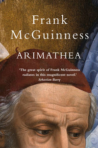
£29.99
Topographic survey of Denmark at 1:100, 000 from Kort & Matrikelstyrelsen, the country’s national survey organization. The maps have contours at 5 metre intervals, with colouring and/or graphics showing various types of terrain & land use: woodlands, orchards, heath, sand & dunes, tidal flats, meadows & marshl&, etc. The maps provide detailed presentation of the road & rail networks & other information expected of topographic mapping at this scale. No specifically tourist information such as waymarked cycling or hiking routes is shown. Standard size sheets cover an area of 56 x 45km / 35x 28 miles approx. Map legend

Includes::
English. To see other titles in this series please click on the series link.IMPORTANT – PLEASE NOTE BEFORE ORDERING:AVAILABILITY: all the maps are now printed on dem&. Delivery from Denmark can take over 4 weeks. Once an order has been placed we cannot accept any returns for credit.COORDINATES: although the maps are meant to have UTM coordinates for EUREF 89 (WGS 84) datum, sheets are sometimes delivered printed without any grid or margin ticks for UTM or latitude & longitude.

...
Archived Product
£6.50
Topographic coverage of the Canary Islands at 1:25, 000 published by the Instituto Geográfico Nacional – Centro Nacional de Información Geografica, the country’s civilian survey organization. The maps have contours at 10m intervals & colouring and/or graphics to show different types of vegetation or land use. Boundaries of national parks & other protected areas are marked. In addition to all the usual information shown on topographic mapping at this scale: detailed presentation of the road network with rural tracks & paths, etc, the maps also show campsites. The maps have a 1-km UTM grid, plus margin ticks for latitude & longitude at 1` intervals. The majority of the titles have been published since late 1990s. Map legend is in Spanish only.COVERAGE: each 25K map covers one quarter of the corresponding 1:50, 000 map, with the numbering system: I = NW quarter, II = NE quarter, III = SW quarter, & IV = SE quarter. To see other titles in this series please click on the series link. ...
Archived Product
£5.99
Ariège & Haute-Garonne départments of France at 1:150, 000 in Michelin’s Local Series, with highlighting for scenic routes, an index, a special panel with best sights & recommended driving tours, & street plans of central Toulouse & Foix. Along the Pyrenees the map extends from west of Bagnères-de-Luchon to Font-Romeau & Mont-Louis, including the whole of Andorra. PLEASE NOTE: our coverage image, provided by the publishers, does not take into account which areas along the edge of the map are blocked by the index & the additional features – the north-western corner above Auch & the north-eastern corner beyond Lavaur are not included. Maps in Michelin’s Local Series of France have the same cartography (road network & place names shown on the maps) as the publishers’ Regional Series at 1:200, 000 but enlarged here to 1:150, 000 to provide greater clarity & larger, easier to read print size. Road network is presented in great detail, indicating width, motorway services & rest areas, dangerous or restricted entry roads, steep gradients, height & weight restrictions, etc. Scenic sections are highlighted. The maps also show selected cycle paths & nature trails. Railway lines are shown with stations & local airports are marked. Symbols indicate various places of interest, with additional star rating for best sights, based on the publishers’ Green Guides for French regions. Satellite-derived base with colouring for the forested areas & boundaries of national or regional parks shows the topography. In the mountainous regions the maps have bold, very effective relief shading, with a large number of names of peaks, passes, & other topographic features. The maps have latitude & longitude lines at 10’ intervals & are indexed. Map legend

Includes::
English. Each title in addition

Includes::
a panel showing the area’s principal roads & places of interest, plus recommendations for sightseeing tours. Also provided are town centre maps of main cities, indicating principal traffic arteries, one way streets & places of interest. Only selected streets are named & listed in the accompanying index. Please click on the series link to see all the titles in this series.


...
Archived Product
£14.99
Jan Morris is one of the great British writers of the post-war era. Soldier, journalist, writer about places (rather than `travel writer`), elegist of the British Empire, novelist, she has fashioned a distinctive prose style that is elegant, fastidious, supple, & sometimes gloriously gaudy. For many readers she is best known for her candid memoir Conundrum, which described the gender reassignment operation she underwent in 1972. But as Ariel demonstrates, this is just one of the many remarkable facts about her life. As James Morris she was the journalist who brought back the story of the conquest of Everest in 1953 & who discovered incontrovertible evidence of British involvement in the Suez Crisis of 1956. She has been described by Rebecca West as the finest prose stylist of her time, & her essays span the entire urban world. Her writings on Wales represent the most thorough literary investigation of that mysterious l&. Derek Johns was Jan Morris`s literary agent for twenty years. Ariel is not a conventional biography, but rather an appreciation of the work & life of someone who besides being a delightful writer is known to many people as a generous, affectionate, witty & irreverent friend. It is published to coincide with her 90th birthday. ...
Archived Product
£9.99
Jan Morris is one of the great British writers of the post-war era. Soldier, journalist, writer about places, elegist of the British Empire, novelist, she is best known to many for her candid memoir Conundrum, which described the gender reassignment operation she underwent in 1972. But, as Ariel demonstrates, this is just one of the many remarkable facts about her life. Derek Johns was Jan Morris`s literary agent for twenty years, & Ariel is a literary life, an appreciation of the work & achievements of someone who besides being a delightful writer is known to many as a generous, affectionate, witty & irreverent friend. ...
Archived Product
£6.99
Arizona in a series of US state maps from the National Geographic with cartography from Mapquest, including city maps of the Phoenix conurbation, downtown Phoenix, Tucson, Flagstaff, Yuma & Bullhead City
- Laughlin, enlargements of the Grand Canyon, Saguaro & Petrified Forest National Parks, plus a scenic Oak Creek Canyon drive route. The map is printed on lightweight, waterproof & tear-resistant plastic paper. Maps in the NGS State Series clearly show each state’s national parks, forests & other protected areas, with topography indicated by subtle relief shading & plenty of names of mountain ranges, valleys, deserts, etc. Indian Reservations are also marked & various places of interest are highlighted, including historical or natural sites, visitor information centres, campsites, etc. Road network indicates toll roads, rest areas & services, & shows driving distances on main routes. Scenic roads are highlighted. The maps have no geographical coordinates. The index lists both counties, shown on the maps with their administrative boundaries, & towns or cities. Each title

Includes::
several enlargements showing in greater detail local towns, national parks & other popular destination, all annotated with places of interest. Also provided are general notes about the state with descriptions of its main sights, a recommendation for a scenic drive, a table of services available in the local sites (both national parks & historical monuments), a calendar of local special events, a distance table & a climate chart.


...
Archived Product
£11.99
Arizona in the Countries & Regions series from Lonely Planet, market-leading comprehensive guides aimed at independent travellers & serving a large range of international destinations. Frank & informal in style, the guides explore an extensive range of sights, activities, accommodation, restaurants & nightlife & are designed for practical use while travelling on the road. Written & researched by a team of experts, each book is independent in its recommendations & suggestions, often offering individual takes on individual destinations. Widely recognised for their reliability, each Lonely Planet country & region guide has the same layout. Introductory sections profile the destination with individual chapters on particular highlights, getting started, (including when to go) itineraries, history, culture, arts, food & drink & the environment. Each guide is organised geographically by region, with individual sections detailing an extensive range of sights, places of interest, attractions, restaurants, nightlife, accommodation & any local activities. The guides have detailed explanations of historical context where relevant. There is also practical guidance on ...
Archived Product
£9.99
Arizona & New Mexico at 1:900, 000 on an indexed, double-side map from ITMB with topography shown by altitude colouring, plus enlargements showing in greater detail Flagstaff & Albuquerque & their environs. Coverage

Includes::
las Vegas & the whole of Lake Mead. Topography is indicated by altitude colouring with bands & spot heights in feet. Road network emphasises main highways & connecting state roads, with driving distances shown on main & selected local routes. Road & junction numbers are clearly marked & the map also indicates the course of Route 66. Symbols highlight various facilities & places of interest, including numerous campsites. The map has latitude & longitude lines at 1ºintervals. Each side has a separate index. Enlargements present in greater detail the environs of Falstaff & Albuqueque. To see other regional titles from ITMB covering USA please click on the series link.

...
Archived Product
£15.99
Completely updated every year, Frommer's Arizona features hundreds of gorgeous color photos of the sights & experiences that await you. Our expert author has researched the best hotels, restaurants, shops, & nightlife spots in Scottsdale & Phoenix, & takes you to every corner of the state, from small, southern towns such as Tombstone to the Four Corners Region, where visitors can connect with Hopi & Navajo communities. Extensive coverage of The Grand Canyon gives you insider information for seeing the park without crowds & the best options for staying in & near the park. Frommer's Arizona also

Includes::
a fold-out sheet map.

...
Archived Product
£15.99
All you need to inspire every step of your journey. An in-depth book, now with free app & e Book. From deciding when to go, to choosing what to see when you arrive, this Insight Guides book is all you need to plan your trip & experience the best of Arizona & the Grand Canyon, with in-depth insider information on must-see, top attractions like Monument Valley, & hidden cultural gems like Tempe Center for the Arts.· Insight Guide Arizona & the Grand Canyon is ideal for travellers seeking immersive cultural experiences, from exploring Grand Canyon National Park, to discovering the Phoenix Zoo· In-depth on history & culture: enjoy special features on Arizona volcanoes & American Indian art, all written by local experts·

Includes::
innovative, unique extras to keep you up-to-date when you`re on the move
- this guide comes with a free e Book, & an app that highlights top attractions & regional information & is regularly updated with new hotel, bar, restaurant, shop & local event listings· Invaluable maps, travel tips & practical information ensure effortless planning, & encourage venturing off the beaten track· Inspirational colour photography throughout
- Insight Guides is a pioneer of full-colour guide books· Inventive design makes for an engaging, easy reading experience


...
Archived Product

Arimathea

`The great spirit of Frank McGuinness radiates in this magnificent novel. Myriad voices converge on one glistening core; it is a high-wire act earthed in the deepest humanity.` Sebastian Barry It is 1950. Donegal. A land apart. Derry city is only fourteen miles away but far beyond daily reach. Into this community comes Gianni, also called Giotto at his birth. A painter from Arrezzo in Italy, he has been commissioned to paint the Stations of the Cross. The young Italian comes with his dark skin, his unusual habits, but also his solitude and his own peculiar personal history. He is a major source of fascination for the entire community. A book of close observation, sharp wit, linguistic dexterity - and of deep sympathy for ordinary, everyday humanity.
RIP - This product is no longer available on our network. It was last seen on 25.09.2019

This page now acts as a permanent archive for this product. Add more information using the comments box below to ensure it can still be found by future generations.

Use our search facility to see if it is available from an alternative contributor.
  • External links may include paid for promotion
  • Availability: Out Of Stock
  • Supplier: Stanfords
  • SKU: 9781847175786
Availability: In Stock
£12.99

Product Description

` The great spirit of Frank Mc Guinness radiates in this magnificent novel. Myriad voices converge on one glistening core; it is a high-wire act earthed in the deepest humanity.` Sebastian Barry It is 1950. Donegal. A land apart. Derry city is only fourteen miles away but far beyond daily reach. Into this community comes Gianni, also called Giotto at his birth. A painter from Arrezzo in Italy, he has been commissioned to paint the Stations of the Cross. The young Italian comes with his dark skin, his unusual habits, but also his solitude & his own peculiar personal history. He is a major source of fascination for the entire community. A book of close observation, sharp wit, linguistic dexterity
- & of deep sympathy for ordinary, everyday humanity.

Reviews/Comments

Add New

Intelligent Comparison

Oooops!
We couldn't find anything!
Perhaps this product's unique.... Or perhaps we are still looking for comparisons!
Click to bump this page and we'll hurry up.

Price History

Vouchers

No voucher codes found.
Do you know a voucher code for this product or supplier? Add it to Insights for others to use.

Facebook

Jargon Buster

Italian - A word used ot descibe something from Italy
Dark - A colour which absorbs visable ligt so apears less light than objects that reflect light
History - Anything that happens in the past. An acedemic subject.
Italy - a country in Europe.
Skin - The largest organ on a human. Its main purpose is to keep liquids inside the body.
Unusual - Something unique and different.
Personal - Something that belongs more to an individual due to it affecting them more by relating to them.

Supplier Information

Stanfords
Stanfords was established in 1853 and opened their iconic Covent Garden flagship store in 1901. They have become the top retailer of maps, travel books and accessories in the UK and arguably offer the largest selection of maps and travel books worldwide. Famous names such as Captain Robert Falcon Scott, Ranulph Fiennes and Michael Palin have purchased from Stanfords. They now have a shop in Bristol and both stores together with other venues operate a calendar of events including talks, book signings and exhibitions. As a specialist map retailer, the map selection is comprehensive and includes road maps, street maps and walking maps from worldwide destinations, as well as a selection of world atlases and wall maps. Books include travel guides and travel literature. Stanfords also stock globes, from miniatures made of blue marble to magnificent floor-standing globes. The website features a selection of interesting articles on travel topics.
Page Updated: 2023-11-12 20:15:36

Community Generated Product Tags

Oh No! The productWIKI community hasn't generated any tags for this product yet!
Menu