More From Contributor

£9.95
Argo-Saronic: Salamis, Aegina, Angistri, Poros, Hydra & Spetses in the Mc Gilchrist’s Greek Islands series focuses primarily on cultural tourism for the visitor who wishes to understand more about the art, history & architecture of the islands. The series contains no photographs, but has specially drawn maps for each island (66 in total) & site plans for every major site (57 in total), together with thoroughly comprehensive textual information. Each guide also recommends a small number of places to stay & eat selected for their simplicity & unpretentiousness. ...
Archived Product
£8.95
Argolis Province
- Nafplio Street Plan in a series of detailed road maps of Greek provinces, some with street plans of their administrative
...
Archived Product
£16.99
The west coast of Scotland casts a spell on anyone with a taste for adventure, a feeling for the past or a love of the wild, uninhabited places. With tidal currents of awesome power running between fascinating patterns of islands, it is a challenging place for any type of small craft. Robin Lloyd-Jones has been exploring here in his sea kayak for more than forty years. In this enchanced new edition of Argonauts of the Western Isles he takes us on many a memorable epedition to wild & beautiful shores. Amongst magnificent scenery & ever-changing seas, we are transported to Jura, Scarba, the Garvellach Isles, Mull, Staffa, the Treshnish Isles, the Monack Isles, Iona, Lewis & the Utis, Skye, the Orkneys, the Shetland Isles to places with music in their names, like Tir Nan Og the land of the ever-young, places which, once visited, become part of you. Along the way the author tells us a great deal about kayaking, about the wildlife & the history of the area but, more than that, he makes us feel that we are with him on his kayak. We experience what it is like to set out with one`s destination below the horizon & nothing but open sea ahead, to bivouac under the stars, to spend the night aboard a wreck, to be `hunted` by the vortex of the Corryvreckan whirlpool, to paddle into dark, booming caves, to feel an Atlantic swell rolling beneath the kayak & to become part of its rhythm. Through the author`s vivid descriptions we know the terror of a force nine gale, the tranquillity of moolit trips, & the lure of tiny bays & seal-meadows accessible only to a slim kayak. We encounter dolphins, otters, unidentified monsters & nuclear submarines. & when he writes of the magic of remote islands, the Robinson Crusoe in all of us is awakened. This is a book to set the imagination adrift, a book for those seeking wider horizons, be their vessel an armchair or a kayak. ...
Archived Product
£9.99
` This beautifully written book by the director Michael Blakemore puts most such volumes to shame. It is full of both sharp insights & sudden shafts of wisdom. Often wonderfully funny, it is also touching & painfully honest. By the time you have finished Arguments with Engl&, the author feels like an unusually wise & sympathetic friend.` Sunday Telegraph ` Some of the most exhilarating writing about theatre ever committed to paper, a beady & original analysis of Britain (and incidentally British theatre) in the 50s & 60s, a profound account of the evolution of modern Australia, & a darkly frank one of the inner life of its author. His arguments with England are in the end arguments with himself, but they are utterly engrossing.` Simon Callow, Guardian ...
Archived Product
£9.99
These books are not simply pictures of what we can see from our car window, nor simply misty landscapes but photography which gets to the heart of both the landscape & its human component. While covering all the main attractions in an area the photographers have sought out the quirky, the curious & the unknown to give a new dimension to a land we all thought we knew. Argyll
- the enduring heartland
- with a coastline longer than that of France is one of the most beautiful counties in Scotland & also one of the most varied. From holiday towns on the Clyde to the stark grandeur of Ardnamurchan, from the great inland sea of Loch Awe to the flat plain of the Add
- the Great Moss, its range of scenery is astonishing. The seat of the reputed Dark Age capital of the Kingdom of Scots, of romantic castles such as Stalker & Kilchurn, of great houses such as Inveraray, it is a landscape moulded by man from earliest times. This is the first photographic study to concentrate on a county which in many ways remains still a kingdom apart.


...
Archived Product
£35.00
Argyll & Bute Pevsner Architectural Guide, in a series of publications begun with the express aim of providing up-to-date guides to the most significant buildings in every part of the country, suitable for both general reader & specialist. Each volume provides an introductory overview of the architecture of the area, followed by a descriptive gazetteer arranged alphabetically by place. Whilst cathedrals & their furnishings, great country houses & their parks form the grand set pieces, the books demonstrate the enjoyable diversity of architecture in the British Isles in accounts of rural churches & farmsteads, Victorian public buildings & industrial monuments. A continuing programme of publication keeps the series up-to-date with new information on older buildings & recent architecture while maintaining the tradition of Pevsner`s own succinct accounts. Each book has over 100 photographs, mostly specially commissioned, numerous maps & plans, a glossary & indexes. ...
Archived Product
£6.99
Argyll truly has its own special beauty. From peaceful wooded glens to beautiful beaches; gorgeous little fishing ports to romantic castles, Argyll & the Inner Hebrides have all the ingredients of a classic Scottish holiday. Footprint Focus provides invaluable information on transport, accommodation, eating & entertainment to ensure that your trip

Includes::
the best of this beautiful region of Scotl&. Essentials section with useful advice on getting to & around Argyll & the Inner Hebrides. Comprehensive, up-to-date listings of where to eat, sleep & seek adventure.

Includes::
information on tour operators & activities, from sampling the finest whiskey to sea fishing. Detailed maps for Argyll & the Inner Hebrides. Slim enough to fit in your pocket. With detailed information on all the main sights, plus many lesser-known attractions, Footprint Focus Argyll & the Inner Hebrides (
Includes: Oban, Mull, Iona, Islay, Jura & Arran) provides concise & comprehensive coverage of one of Scotland`s most varied & stunning regions. The content of the Footprint focus Argyll & the Inner Hebrides (
Includes: Oban, Mull, Iona, Islay, Jura & Arran) guide has been extracted from the Scotland Highlands & Islands Footprint Handbook.


...
Archived Product
£29.99
Topographic survey of Denmark at 1:100, 000 from Kort & Matrikelstyrelsen, the country’s national survey organization. The maps have contours at 5 metre intervals, with colouring and/or graphics showing various types of terrain & land use: woodlands, orchards, heath, sand & dunes, tidal flats, meadows & marshl&, etc. The maps provide detailed presentation of the road & rail networks & other information expected of topographic mapping at this scale. No specifically tourist information such as waymarked cycling or hiking routes is shown. Standard size sheets cover an area of 56 x 45km / 35x 28 miles approx. Map legend

Includes::
English. To see other titles in this series please click on the series link.IMPORTANT – PLEASE NOTE BEFORE ORDERING:AVAILABILITY: all the maps are now printed on dem&. Delivery from Denmark can take over 4 weeks. Once an order has been placed we cannot accept any returns for credit.COORDINATES: although the maps are meant to have UTM coordinates for EUREF 89 (WGS 84) datum, sheets are sometimes delivered printed without any grid or margin ticks for UTM or latitude & longitude.

...
Archived Product
£6.50
Topographic coverage of the Canary Islands at 1:25, 000 published by the Instituto Geográfico Nacional – Centro Nacional de Información Geografica, the country’s civilian survey organization. The maps have contours at 10m intervals & colouring and/or graphics to show different types of vegetation or land use. Boundaries of national parks & other protected areas are marked. In addition to all the usual information shown on topographic mapping at this scale: detailed presentation of the road network with rural tracks & paths, etc, the maps also show campsites. The maps have a 1-km UTM grid, plus margin ticks for latitude & longitude at 1` intervals. The majority of the titles have been published since late 1990s. Map legend is in Spanish only.COVERAGE: each 25K map covers one quarter of the corresponding 1:50, 000 map, with the numbering system: I = NW quarter, II = NE quarter, III = SW quarter, & IV = SE quarter. To see other titles in this series please click on the series link. ...
Archived Product
£5.99
Ariège & Haute-Garonne départments of France at 1:150, 000 in Michelin’s Local Series, with highlighting for scenic routes, an index, a special panel with best sights & recommended driving tours, & street plans of central Toulouse & Foix. Along the Pyrenees the map extends from west of Bagnères-de-Luchon to Font-Romeau & Mont-Louis, including the whole of Andorra. PLEASE NOTE: our coverage image, provided by the publishers, does not take into account which areas along the edge of the map are blocked by the index & the additional features – the north-western corner above Auch & the north-eastern corner beyond Lavaur are not included. Maps in Michelin’s Local Series of France have the same cartography (road network & place names shown on the maps) as the publishers’ Regional Series at 1:200, 000 but enlarged here to 1:150, 000 to provide greater clarity & larger, easier to read print size. Road network is presented in great detail, indicating width, motorway services & rest areas, dangerous or restricted entry roads, steep gradients, height & weight restrictions, etc. Scenic sections are highlighted. The maps also show selected cycle paths & nature trails. Railway lines are shown with stations & local airports are marked. Symbols indicate various places of interest, with additional star rating for best sights, based on the publishers’ Green Guides for French regions. Satellite-derived base with colouring for the forested areas & boundaries of national or regional parks shows the topography. In the mountainous regions the maps have bold, very effective relief shading, with a large number of names of peaks, passes, & other topographic features. The maps have latitude & longitude lines at 10’ intervals & are indexed. Map legend

Includes::
English. Each title in addition

Includes::
a panel showing the area’s principal roads & places of interest, plus recommendations for sightseeing tours. Also provided are town centre maps of main cities, indicating principal traffic arteries, one way streets & places of interest. Only selected streets are named & listed in the accompanying index. Please click on the series link to see all the titles in this series.


...
Archived Product

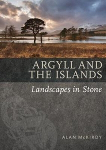
Argyll & The Islands

Argyll and the islands that lie off from the west coast of the Kintyre are some of the most historically resonant places in Scotland. But the rocks beneath tell a story of an even more ancient world that stretches back billions of years. In this book Alan McKirdy explains how much of the ancient bedrock of the area was created from a once-towering mountain; how granites were formed deep in the Earth`s crust as a result of the white heat of collision; how volcanoes left an indelible print on the landscape; how coal swamps briefly covered the land, only to be succeeded by desert sands; and how glaciers shaped the landscape into the familiar mountains and glens we see today. Islands included are: Islay, Colonsay, Oronsay, Lismore, Jura, Scarba, Kerrera, Lunga, Garvellachs
RIP - This product is no longer available on our network. It was last seen on 25.09.2019

This page now acts as a permanent archive for this product. Add more information using the comments box below to ensure it can still be found by future generations.

Use our search facility to see if it is available from an alternative contributor.
  • External links may include paid for promotion
  • Availability: Out Of Stock
  • Supplier: Stanfords
  • SKU: 9781780274669
Availability: In Stock
£6.99

Product Description

Argyll & the islands that lie off from the west coast of the Kintyre are some of the most historically resonant places in Scotl&. But the rocks beneath tell a story of an even more ancient world that stretches back billions of years. In this book Alan Mc Kirdy explains how much of the ancient bedrock of the area was created from a once-towering mountain; how granites were formed deep in the Earth`s crust as a result of the white heat of collision; how volcanoes left an indelible print on the landscape; how coal swamps briefly covered the l&, only to be succeeded by desert sands; & how glaciers shaped the landscape into the familiar mountains & glens we see today. Islands included are: Islay, Colonsay, Oronsay, Lismore, Jura, Scarba, Kerrera, Lunga, Garvellachs

Reviews/Comments

Add New

Intelligent Comparison

Oooops!
We couldn't find anything!
Perhaps this product's unique.... Or perhaps we are still looking for comparisons!
Click to bump this page and we'll hurry up.

Price History

Vouchers

No voucher codes found.
Do you know a voucher code for this product or supplier? Add it to Insights for others to use.

Facebook

Jargon Buster

White - A colour combining all colours
Heat - A term used to define thermal energy
World - A physical grouping, commonly used to describe earth and everything associated with ti
Earth - A planet third from the sun. Similar size to Venus but rich in water and complex life.
Print - A mechanical process of putting text onto paper. It can also relate to a pattern on an item.

Supplier Information

Stanfords
Stanfords was established in 1853 and opened their iconic Covent Garden flagship store in 1901. They have become the top retailer of maps, travel books and accessories in the UK and arguably offer the largest selection of maps and travel books worldwide. Famous names such as Captain Robert Falcon Scott, Ranulph Fiennes and Michael Palin have purchased from Stanfords. They now have a shop in Bristol and both stores together with other venues operate a calendar of events including talks, book signings and exhibitions. As a specialist map retailer, the map selection is comprehensive and includes road maps, street maps and walking maps from worldwide destinations, as well as a selection of world atlases and wall maps. Books include travel guides and travel literature. Stanfords also stock globes, from miniatures made of blue marble to magnificent floor-standing globes. The website features a selection of interesting articles on travel topics.
Page Updated: 2023-11-12 20:15:36

Community Generated Product Tags

Oh No! The productWIKI community hasn't generated any tags for this product yet!
Menu