More From Contributor
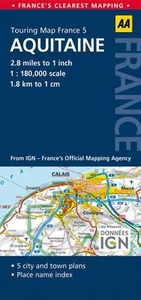
£39.99
The Aquapure Traveller, by Pure Hydration is just like a water bottle but its cap features a water purification system which uses M.A.D. (Mechanically Advanced Disinfection) Technology & it is completely chemical free. It filters & purifies water eliminating viruses & bacteria such as E-Coli, Polio, Hepatitis A, & others. It removes waterborne pathogens, including Giardia, Crytosporidium, etc. It removes toxic chemicals & heavy metals. It removes bad taste, odours & sediment. The 0.660 l bottle is made from hard durable plastic. You can use water from hotel & restaurant taps, standpipes streams or rivers. Its filter cap will purify an average of 350L during its lifetime, & is the only portable water purifier officially endorsed by the Hospital of Tropical Diseases London. Replacement water filters can be purchased separately. This method is really easy to use, there is no chemical involved or difficult procedure, just fill up the bottle & drink! By using the Aquapure Traveller, you could save the environment the disposal of the equivalent of 700 plastic bottles per filter. It is the perfect solution for holiday makers, adventurers, business travellers &, in fact, anyone who needs access to pure, fresh water anywhere in the world. Items are attractively packaged & suitable as a gift. ...
Archived Product
£585.00
Made of wood this model boat has metal details & leather seats. Perfect to display in the office or at home. The Jaguar XK120 ruled the road: Doris Day & Cary Grant were Oscar nominated. It was a time of peace, & optimism was unbridled. It was then that Rivas roared across the Lago di Como & skimmed the Mediterranean waves off St. Tropez. Thunderboats (also called Hydroplanes) racing with each other at record speed. Stateside, the luxurious Chris Crafts were de rigeur with Hollywood elite. If we do not have this item in stock we will order it for you from our supplier. Delivery generally takes 3 weeks within the UK. For overseas delivery queries please email sales@stanfords.co.uk ...
Archived Product
£9.99
Kang Chol-Hwan is the first survivor of a North Korean concentration camp to escape the `hermit kingdom` & tell his story to the world. This memoir reveals the human suffering in his camp, with its forced labour, frequent public executions & near-starvation rations. Kang eventually escaped to South Korea via China to give testimony to the hardships & atrocities that constitute the lives of the thousands of people still detained in the gulags today. Part horror story, part historical document, part memoir, part political tract, this story of one young man`s personal suffering finally gives eye-witness proof to this neglected chapter of modern history. ...
Archived Product
£17.99
Topographic survey of Portugal at 1:50, 000 from the Instituto Geográfico do Exército, the country’s military survey organisation. The maps have contours at 20m intervals & in addition to the standard features shown on topographic mapping at this scale also indicate various types of terrain or vegetation (s&, terraces, rocks, woodlands, vineyards, etc). Each sheet covers an area of 32 x 20km (20 x 12.5 miles approx). The maps have a 1-km UTM grid plus latitude & longitude coordinates for the map corners. Map legend & a glossary of terms used on the maps include English.EDITION DATES: most titles in this series date from 1990s or later. To see all the titles in this series please click on the series link. ...
Archived Product
£17.99
Topographic survey of Portugal at 1:50, 000 from the Instituto Geográfico Português, the country’s civilian survey organisation. The maps have contours at 25m intervals & in addition to the standard features shown on topographic mapping at this scale also indicate various types of vegetation (vineyards, olive groves, etc). Each sheet covers an area of 32 x 20km (20 x 12.5miles approx). The maps have latitude & longitude margin ticks at 1’ intervals & UTM coordinates for the map corners – each sheet also shows conversion details from BBLx (Bessel-Bonnie system, Datum Lisbon) to UTM. Map legend is in Portuguese only.EDITION DATES: most titles in this series have now been updated in the 1990s or later. To see all the titles in this series please click on the series link. ...
Archived Product
£5.49
Aquitaine at 1:180, 000 in a series of double-sided, indexed road maps of French regions from the AA with cartography from the Insitut Géographique National (IGN). Small plans show main streets & principal routes across Bordeaux, Bergerac & Mont-de-Marsan. Cartography is identical to IGN’s own regional series at 1:250, 000, simply enlarged without additional information. Detailed mapping of regional & minor local roads is combined with very clear presentation of motorways & main national routes, showing junction numbers, locations of toll gates or fixed speed cameras, & service or rest areas. The maps indicate access restrictions, unmaintained sections of minor local roads, etc. Intermediate driving distances are marked on main & secondary routes. The maps also show the country’s railway network with stations & local stops. Towns of particular tourist interest are highlighted & a wide range of symbols mark locations of various places of interest, including the country’s cultural heritage, notable natural sights, etc. National & regional parks are prominently marked. Topography is shown by relief shading with colouring & graphics to indicate wooded areas, marshes, salt marshes, dry or wet sand shoreline, etc. Unlike the IGN regional series, the AA maps do not show geographical coordinates. Current edition of this map was published in January 2014.PLEASE READ BEFORE ORDERING
- COVERAGE BY EACH MAP: the publishers’ series grid shown on our website provides only a very approximate picture how the various titles overlap, since it does not take into account which parts of each sheet are used for street plans & the index. For the exact area please see the coverage image provided with this title. To see the list of all the titles in this series please click on the series link.
...
Archived Product
£20.99
Aquitaine in a series of guides to France’s navigable rivers & canals from Editions du Breil, providing mapping of the waterways with better presentation of the surrounding countryside, including street plans of main towns along the routes. The maps present the waterways with locks, mooring places, etc. & the surrounding localities annotated with symbols indicating various facilities & places of interest. Most map panels cover a full page, enabling the publishers to provide better coverage of the surrounding countryside, showing more local towns & villages plus the connecting roads. The guides also include better street plans of selected larger towns, indicating main sights, etc. Navigating instructions or tips & information about various facilities or places of interest are usually located on a page opposite to the map of the route. The guides also contain general information on rules & regulations for navigating along France’s inland waterways, plus examples of signs & signals. All of the text, explanations & the map legend are in French, English & German. To see the list of other titles in this series please click on the series link. ...
Archived Product
£13.99
A new handy cycling route atlas. Choose your route using the free mini map enclosed & follow your progress using the atlas.

...
Archived Product
£15.99
Aquitaine Guide Vert *FRENCH Edition* in Michelin’s Green Guide series covering France, with all the regions available either in English editions or in French versions. Drawing on Michelin’s long experience, the guides are renowned for their individual ‘star rating’ of sights & attractions. Listings in each guide are organized alphabetically, allowing readers to access information quickly. Towns are given overall star rating, with their sights & attractions also rated individually. Where appropriate, a street plan of the town centre is provided, indicating car parks & accompanied by an index of main streets & a list of sights highlighted on it. For many towns a recommended sightseeing tour is also marked on the plan. Entries for important churches are accompanied by detailed plans. Recommended car tours have overview maps showing road numbers & locations of the sights. Where necessary, the guides give opening hours & contact details. Many entries have an “ Address Book” section with Michelin’s recommendations for where to stay & where to eat. Each guide has a very extensive introductory section with practical information & pre-trip tips, chapters on history, art & culture (particularly strong on architectural styles, explained by excellent drawings), fauna & flora, etc. Fold-out flaps in the book covers provide an overview of the recommended sights and/or car tours.* * French language guides* have a larger number of individual entries than included in the corresponding English titles, as well as more exhaustive descriptions, with wider coverage of local history and/or famous people connected with a given location.* * English language guides* have more recommendations for car tours. The “ Address Book” sections often include shopping suggestions. ...
Archived Product
£5.99
French region of Aquitaine, including the southern part of the Atlantic coast, the Bordeaux wine region & the western part of the Pyrenees, at 1:200, 000 in a series of double-sided touring maps from Michelin. The map

Includes::
a city centre street plan of Bordeaux indicating principal traffic arteries, one way streets & places of interest, with selected streets named & listed in the accompanying index. Maps in the Michelin’s REGIONAL series are designed to cover a large area in each title & offer a more convenient touring alternative to the publishers’ LOCAL coverage of France at 1:150, 000. The maps present the road network in great detail, indicating width & the number of lanes, motorway services & rest areas, dangerous or restricted entry roads, steep gradients, height & weight restrictions, etc. Scenic sections are highlighted. The maps also show selected cycle paths & nature trails. Railway lines are shown with stations & local airports are marked. Satellite-derived base with colouring for the forested areas & boundaries of national or regional parks shows the topography. In the mountainous regions the maps have bold, very effective relief shading, with a large number of names of peaks, passes, & other topographic features. The maps have latitude & longitude lines at 10’ intervals & are indexed. Map legend

Includes::
English. To see the list of all the regional titles in this series please click on the series link.


...
Archived Product

Aquitaine

Aquitaine, the administrative region of France stretching along the Atlantic coast from the Garonne estuary and Bordeaux to the western Pyrenees, presented at 1:280, 000 on a tourist map produced by the IGN in cooperation with the regional authorities.The base map highlights the region
RIP - This product is no longer available on our network. It was last seen on 25.09.2019

This page now acts as a permanent archive for this product. Add more information using the comments box below to ensure it can still be found by future generations.

Use our search facility to see if it is available from an alternative contributor.
  • External links may include paid for promotion
  • Availability: Out Of Stock
  • Supplier: Stanfords
  • SKU: 3282118110117
Availability: In Stock
£8.50

Product Description

Aquitaine, the administrative region of France stretching along the Atlantic coast from the Garonne estuary & Bordeaux to the western Pyrenees, presented at 1:280, 000 on a tourist map produced by the IGN in cooperation with the regional authorities. The base map highlights the region

Reviews/Comments

Add New

Price History

Vouchers

No voucher codes found.
Do you know a voucher code for this product or supplier? Add it to Insights for others to use.

Facebook

Jargon Buster

France - A state situated in Western Europe with several overseas territories.
Regional - An adjective to describe a set geographic area.

Supplier Information

Stanfords
Stanfords was established in 1853 and opened their iconic Covent Garden flagship store in 1901. They have become the top retailer of maps, travel books and accessories in the UK and arguably offer the largest selection of maps and travel books worldwide. Famous names such as Captain Robert Falcon Scott, Ranulph Fiennes and Michael Palin have purchased from Stanfords. They now have a shop in Bristol and both stores together with other venues operate a calendar of events including talks, book signings and exhibitions. As a specialist map retailer, the map selection is comprehensive and includes road maps, street maps and walking maps from worldwide destinations, as well as a selection of world atlases and wall maps. Books include travel guides and travel literature. Stanfords also stock globes, from miniatures made of blue marble to magnificent floor-standing globes. The website features a selection of interesting articles on travel topics.
Page Updated: 2023-11-12 20:15:36

Community Generated Product Tags

Oh No! The productWIKI community hasn't generated any tags for this product yet!
Menu