
 United Kingdom
 France
 Germany
 Netherlands
 Sweden
 USA
USA
 Italy
Italy
 Spain
Spain
More From Contributor


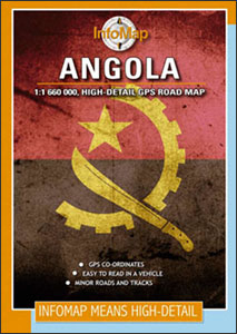
Angola InfoMap
Angola on a double-side road map from South African publishers International Motoring Productions with GPS waypoints for selected towns or settlements. The map, one of a series of similar maps covering countries and selected regions of southern Africa, has rather simple cartography with somewhat basic elevation tinting and spot heights. Roads are classified as national, major, minor, 4WD tracks and minor tracks/paths, and show driving distances on most sections of main routes, locations of fuel stations, plus border crossings to neighbouring countries. Local airports and airfields are marked. Symbols indicate campsites and tourist lodges, plus a few places of interest (mostly not identified). GPS waypoints are provided for selected towns and villages, mainly in the western half
of the country, including Cabinda. The map also has latitude and longitude lines at intervals of 1º. Outside Angola’s borders information is limited to main roads leading from border crossings.
of the country, including Cabinda. The map also has latitude and longitude lines at intervals of 1º. Outside Angola’s borders information is limited to main roads leading from border crossings.

Product Description
Reviews/Comments
Add New
Intelligent Comparison
Archived Product
Angola ITMB Stanfords
£9.99
Vouchers
No voucher codes found.
Do you know a voucher code for this product or supplier? Add it to Insights for others to use.
Do you know a voucher code for this product or supplier? Add it to Insights for others to use.
 Denmark