
 United Kingdom
 France
 Germany
 Netherlands
 Sweden
 USA
USA
 Italy
Italy
 Spain
Spain
More From Contributor


Algarve Walking
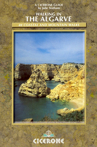
Walking in the Algarve is Julie Statham’s Cicerone guide to some of the best walking opportunities on Portugal’s south coast. The guide covers walks across the Algarve region, taking in the countryside outside Faro as well as the long Atlantic coastline. The author explores a region with a rich variety of scenery from volcanic hills to dramatic limestone escarpments. The Algarve’s climate of mild sunny winters and long hot summers make it an ideal walking destination. The guide is divided into a selection of 34 full and half-day walks offering a mixture of coastal, mountain and inland scenery. Each walk has an information box detailing the total distance and time, difficulty grading and access to the route. There is also a general overview of what walkers can expect from the route
ahead. A The guide’s introduction gives practical tips on when to go, getting there, travelling around, accommodation as well as notes on geology, wild flowers, and birds, flowers and protected areas. Detailed walk descriptions are accompanied by colour photographs illustrating some of the highlights of the region.
ahead. A The guide’s introduction gives practical tips on when to go, getting there, travelling around, accommodation as well as notes on geology, wild flowers, and birds, flowers and protected areas. Detailed walk descriptions are accompanied by colour photographs illustrating some of the highlights of the region.

Product Description
Reviews/Comments
Add New
Vouchers
No voucher codes found.
Do you know a voucher code for this product or supplier? Add it to Insights for others to use.
Do you know a voucher code for this product or supplier? Add it to Insights for others to use.
 Denmark