More From Contributor
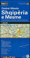
£6.95
USA in the Culture Smart range of pocket-sized guide books; providing detailed information on local customs, culture, etiquette & manners & ensuring that visitors are prepared for a diverse range of social environments. The series covers an extensive number of countries worldwide & are designed both for those working & living abroad, as well as for visitors who do not want to offend, either intentionally or inadvertently. Their aim is to prevent readers from making embarrassing mistakes & feel confident in unfamiliar situations, while preparing them before arrival on what to expect & how to behave. Each guide is arranged thematically, with dedicated individual chapters on land & people, values & attitudes, customs & traditions, making friends, people at home, ...
Archived Product
£59.50
When will Albania join the EU? Will accession help Albania to achieve prosperity, stability & prosperity? &, what factors are helping it towards this end & what factors are holding it back? An original study of Albania & its relations with the EU, this is the first book to identify & analyse the problems of the country as it moves towards membership of the Union. It explores the political, economic & social transformations needed to make Albanian membership possible. The authors highlight the enormous democratic changes that have occurred in post-communist Albania, as well as the many obstacles that still remain. This balanced & objective assessment will be an essential resource for everyone interested in the history & future of the Balkans & the EU. ...
Archived Product
£16.99
This new, thoroughly updated sixth edition of Bradt`s Albania remains the only standalone guide to this dynamic & rapidly modernising eastern European country, from the capital, Tirana, a lively European city, with shopping malls, cycle paths, museums, galleries & historic buildings, to remote outposts where traditional ways of life prevail. Updated by expert author Gillian Gloyer, it

Includes::
all developments since the last edition, reflecting changes such as continued investment in the road network & construction of fast highways connecting main cities, enhanced hotel provision & new museums dedicated to Albania`s communist history. Despite such modernisation, Albania is one of very few European countries where it is still possible to immerse yourself in traditional lifestyles & culture, & Bradt`s Albania provides details of where to experience this for yourself. In highland villages, people tend their livestock & gather their crops with little or no mechanisation; they milk their cows & goats by h&, they make their own cheese & bread, they distil home-made spirits from local fruits & berries. In addition, many villagers have opened up their traditional homes as guest-houses, offering a wonderful opportunity to experience their culture first-h&. Bradt`s Albania also

Includes::
details of watching the country`s rare wildlife, such as wildcats, lynx, wolves & bears, & of visiting its three World Heritage Sites: the archaeological site & national park of Butrint & the Ottoman cities of Berati & Gjirokastra. Iso-polyphony, the traditional music of the south-west, is also listed as part of World Heritage by UNESCO. With rigorously researched historical & archaeological background information, detailed notes on popular & less well-known hiking routes & other outdoor activities, specialist contributors on wildlife, military history & other topics, & an unparalleled wealth of practical advice for the independent traveller, Bradt`s Albania is the ideal companion for discovering this intriguing country.


...
Archived Product
£16.99
Albania in the Travel Guide series from Bradt; encompassing a comprehensive range of titles to destinations worldwide, with a particular focus on Africa, Central & South America. Bradt are one of the country’s leading independent publishers & have an ethos that focuses on responsible travel, in alliance with a philosophy of sustainability; both in the destinations the guides cover but also in encouraging tourists to limit the impact they have on the local environment. Bradt guides have a reputation for appealing to more independent travelers & often cover destinations that are not available from other publishers. Each guide opens with two comprehensive chapters on Background & Practical Information, covering details of the country’s geography, culture, natural history, government & politics, economy, people, language, religion, education & culture. Important practical advice

Includes::
when to visit, highlights, suggested itineraries, tour operators, red tape, embassies & consulates, getting there & away, health, safety, what to take, money, budgeting, getting around, accommodation, eating & drinking, public holidays, shopping, arts & entertainment, media & communications, business, travel culture & cultural etiquette. Individual sections are organized geographically by region & typically open with information on practicalities & orientation, before focusing on what to see & where to go. Information on what to see, where to stay, where to eat & how to find your way around is provided, with a range of budgets catered for. Simple black & white maps locate key visitor sites & places of accommodation. Bradt Travel Guides include appendices that provide an in-depth introduction to the language of each country, a glossary of terms & a listing of books & internet resources providing further information on the destination.

...
Archived Product
£15.99
This new edition, like the previous, places its emphasis on the cultural & outdoor activities of Albania rather than overdeveloped beaches. Tirana, the capital, is covered in detail, from Communist nostalgia & Skanderberg Square to nearby Mount Dajti National Park & the Krraba Pass. Albania covers sites such as Butrint with its complex ruins, dating back 2500 years, & the hilltop site of Byllis with its ruins of Illyrian houses, Roman buildings, & Byzantine basilicas. Full details on outdoor activities, including cycling routes & hikers' trails countrywide are also included. ...
Archived Product
£10.99
Albania at 1:400, 000 on an indexed road map from Freytag & Berndt, with coverage also including the whole of Montenegro & Kosovo, large part of Macedonia, & within Greece extending south to Ioannina & Trikala. Topography is shown by relief shading with colouring for woodlands & names of mountain ranges. National park & other protected areas are highlighted. Road network gives driving distances on many local routes & shows border crossings. Railway lines are included, also local airports & ferry ports on the Adriatic. Symbols highlight various places of interest including campsites, golf courses, etc. Within Kosovo most location are shown with dual place names (Albanian & Serbian). The map has latitude & longitude lines at intervals of 30’. The index is on the reverse. Map legend

Includes::
English.

...
Archived Product
£10.99
Albania at 1:150, 000 on a very large, indexed, double-sided road map from Freytag & Berndt prominently highlighting publishers’ recommendations of 10 best sights, each described in the accompanying booklet. The map divides north/south with Tirana included on both sides. The country’s topography is vividly presented by relief shading, with spot heights & names of mountain ranges, etc. National parks & other protected areas are highlighted. Road network

Includes::
small local roads, most shown with driving distances. Scenic routes are highlighted. Railway lines are shown with stations & regional airports are marked. The map also shows internal administrative boundaries with names of the provinces. Symbols indicate various facilities & places of interest including campsites. The publishers’ recommendations of the country’s 10 best sights are prominently highlighted & have multilingual descriptions provided in the index booklet attached to the map cover. Latitude & longitude lines are drawn on the map at 10’ intervals. Map legend & the descriptions include English.

...
Archived Product
£9.99
Albania at 1:210, 000 on an indexed, double-sided map from ITMB with street plans of Tirana, Gjirokaster, Berat, Vlore, Durres, Shkoder & Korce. The map divides the country north/south, with a good overlap between the sides, & presents its topography by altitude colouring, with names of mountain ranges, peaks, etc. National parks & other protected areas are highlighted. Road network

Includes::
selected tracks & seasonal roads, shows locations of border crossings & gives distances on main routes. Railway lines are included & the map also shows internal administrative boundaries & names of the provinces. Symbols mark various places of interest. Each side has a separate index. Latitude & longitude lines are drawn at 30’. Seven insets provide street plans of the country’s main towns, indicating principal traffic arteries, naming main & selected smaller streets, & highlighting selected tourist accommodation & various places of interest.

...
Archived Product
£9.99
Northern Albania at 1:200, 000 in a series of three indexed, GPS compatible touring maps from the Tirana-based cartographic publishers Vektor with a vivid presentation of the country’s topography through contours & bold altitude colouring, plus locations of campsites, beaches & other places of interest. Coverage extends south to Laç & Peshkopi. Road network is graded into six types, from motorways to minor dirt roads, & indicates border crossings plus driving distances on many local routes. Railway lines are included & local airports are marked. Symbols highlight campsites, beaches, archaeological & historical sites, caves, etc. The maps also show internal administrative divisions & administrative status of towns. Topography is presented by altitude colouring & contour lines, with spot heights & plenty of names of mountain ranges, peaks, etc. National parks & nature reserves are prominently highlighted. The maps have latitude & longitude lines at 10’ intervals. The index is next to the map. Please note: border crossings are prominently marked but beyond topographic colouring no road or other information is provided outside the country’s borders. For the other two titles in this series please click on the series link. ...
Archived Product
£11.50
Albania at 1:220, 000on an indexed, waterproof & tear-resistant road map with topographic & tourist information. The map, published by Reise Know-How as part of their highly acclaimed World Mapping Project, is double-sided to provide the best balance between a good scale & a convenient size sheet. The map divides the country north/south with a generous overlap between the sides. Road & rail networks are easy to see on a clear base which presents topography by altitude colouring with contours, spot heights, mountain passes & names of mountain ranges. The map also indicates boundaries of national parks & other protected areas. Road network

Includes::
local roads & tracks, indicates scenic routes & gives driving distances on main & some secondary roads. Railway lines are included & local airports are marked. Internal administrative boundaries are shown with names of the provinces. Symbols highlight various places of interest, including campsites, UNESCO world heritage sites, archaeological remains, castles & churches, museums, viewpoints, beaches, etc. The map has latitude & longitude lines at intervals of 10’ & a UTM grid, plus an extensive index of localities. Map legend

Includes::
English. ” World Mapping Project” is an extensive series of maps at varying scales, aiming to provide coverage of countries & regions worldwide using clear, well presented cartography with both topographic & tourist information.


...
Archived Product

Albania Central

Central Albania at 1:200, 000 in a series of three indexed, GPS compatible touring maps from the Tirana-based cartographic publishers Vektor with a vivid presentation of the country’s topography through contours and bold altitude colouring, plus locations of campsites, beaches and other places of interest. Coverage extends from Laç north of Tirana to Fier, Berat and Korçë in the south.Road network is graded into six types, from motorways to minor dirt roads, and indicates border crossings plus driving distances on many local routes. Railway lines are included and local airports are marked. Symbols highlight campsites, beaches, archaeological and historical sites, caves, etc. The maps also show internal administrative divisions and administrative status of towns.Topography is
presented by altitude colouring and contour lines, with spot heights and plenty of names of mountain ranges, peaks, etc. National parks and nature reserves are prominently highlighted. The maps have latitude and longitude lines at 10’ intervals. The index is next to the map.Please note: border crossings are prominently marked but beyond topographic colouring no road or other information is provided outside the country’s borders.For the other two titles in this series please click on the series link.
RIP - This product is no longer available on our network. It was last seen on 25.09.2019

This page now acts as a permanent archive for this product. Add more information using the comments box below to ensure it can still be found by future generations.

Use our search facility to see if it is available from an alternative contributor.
  • External links may include paid for promotion
  • Availability: Out Of Stock
  • Supplier: Stanfords
  • SKU: 9789604487769
Availability: In Stock
£9.99

Product Description

Central Albania at 1:200, 000 in a series of three indexed, GPS compatible touring maps from the Tirana-based cartographic publishers Vektor with a vivid presentation of the country’s topography through contours & bold altitude colouring, plus locations of campsites, beaches & other places of interest. Coverage extends from Laç north of Tirana to Fier, Berat & Korçë in the south. Road network is graded into six types, from motorways to minor dirt roads, & indicates border crossings plus driving distances on many local routes. Railway lines are included & local airports are marked. Symbols highlight campsites, beaches, archaeological & historical sites, caves, etc. The maps also show internal administrative divisions & administrative status of towns. Topography is presented by altitude colouring & contour lines, with spot heights & plenty of names of mountain ranges, peaks, etc. National parks & nature reserves are prominently highlighted. The maps have latitude & longitude lines at 10’ intervals. The index is next to the map. Please note: border crossings are prominently marked but beyond topographic colouring no road or other information is provided outside the country’s borders. For the other two titles in this series please click on the series link.

Reviews/Comments

Add New

Intelligent Comparison

Oooops!
We couldn't find anything!
Perhaps this product's unique.... Or perhaps we are still looking for comparisons!
Click to bump this page and we'll hurry up.

Price History

Vouchers

No voucher codes found.
Do you know a voucher code for this product or supplier? Add it to Insights for others to use.

Facebook

Jargon Buster

GPS - Global Positioning System - Global position using satellites
Network - A link and communication between things. Often computers or people.
Road - a manmade lane or a path that is used to speed up travel.
Altitude - Something that can be quite high in relation to sea or ground level.
Borders - A line that sometimes can be built up separating off an area, e.g. countries "the welsh boarder"

Supplier Information

Stanfords
Stanfords was established in 1853 and opened their iconic Covent Garden flagship store in 1901. They have become the top retailer of maps, travel books and accessories in the UK and arguably offer the largest selection of maps and travel books worldwide. Famous names such as Captain Robert Falcon Scott, Ranulph Fiennes and Michael Palin have purchased from Stanfords. They now have a shop in Bristol and both stores together with other venues operate a calendar of events including talks, book signings and exhibitions. As a specialist map retailer, the map selection is comprehensive and includes road maps, street maps and walking maps from worldwide destinations, as well as a selection of world atlases and wall maps. Books include travel guides and travel literature. Stanfords also stock globes, from miniatures made of blue marble to magnificent floor-standing globes. The website features a selection of interesting articles on travel topics.
Page Updated: 2023-11-12 20:15:36

Community Generated Product Tags

Oh No! The productWIKI community hasn't generated any tags for this product yet!
Menu