More From Contributor

£30.00
Detailed physical wall map of Alaska State at a scale of 1:2, 500, 000. The cartography shows relief through a stunning, ...
Archived Product
£14.99
Lonely Planet knows Alaska. Our 9th edition guarantees an adventure at every turn, whether you're watching glaciers calve from a boat, hiking in the Bush or exploring Alaskan Native culture & polar bears in Barrow.
Lonely Planet guides are written by experts who get to the heart of every destination they visit. This fully updated edition is packed with accurate, practical & honest advice, designed to give you the information you need to make the most of your trip.
In This Guide:
New Alaska for Families & Cruising in Alaska chapters
Full-Color Alaskan Wildlife chapter
Unique Green Index to help you make your travels ecofriendly


...
Archived Product
£18.99
Alaska, The Last Frontier, is a land of breathtaking natural scenery & a rich cultural heritage. From Denali & Glacier Bay National Parks to the outpost of Ketchikan to arctic Barrow to the spectacular Dalton Highway, expert travel writer & Alaska authority Bob Devine is a deft guide to all the best spots, & lesser-known ones as well. The book`s seven chapters cover the Southeast`s Inside Passage, Anchorage, Kenai Peninsula, the Southwest, Prince William Sound & Wrangell-St. Elias National Park, Denali National Park & environs, & the Bush. Special features include in-depth spreads on native arts, bear watching, the birders of Attu Isl&, sled dog touring, sea kayaking instruction, gold panning, & national park field seminars; as well as specially mapped driving & walking tours, among them a spectacular drive around Kodiak Isl&. As in all National Geographic Travelers, vivid photographs capture Alaska`s beauty, & detailed maps ensure you won`t get lost. ...
Archived Product
£7.99
Quick to read, light to carry with expert advice in all price ranges, Frommer's Easy Guide to Alaskan Cruises & Ports of Call 2014 is the complete up-to-date reference for travelers who want to maximize their vacation cruise in the smartest, most time-efficient way. Frommer's trademark candid & accessible expertise offers reviews on the strengths & weaknesses in such areas as overall facilities, ship maintenance, decor, activities & kids programs. It also features advice on the perfect off-ship excursions with practical tips & suggested itineraries for getting the most out of your time ashore. ...
Archived Product
£12.95
Thirty years ago, the celebrated American writer Edward Hoagl&, in his early fifties & already with a dozen acclaimed books under his belt, decided to have, instead of a mid-life crisis, a mid-life adventure. Pencil & notebook at the ready, Hoagland lit out to explore & write about one of the last truly wild territories remaining on the face of the earth: Alaska. From the Arctic Ocean to the Kenai Peninsula, & the backstreet bars of Anchorage to the Yukon River, Hoagland traveled the real Alaska from top to bottom. En route, he chronicled the lives of an astonishing & unforgettable array of prospectors, trappers, millionaire freebooters, drifters, oilmen, Inuits, & a remarkably kind & capable frontier nurse named Linda. In his foreword, novelist Howard Frank Mosher describes Edward Hoagland's Alaska travel memoir as the best book ever written about America's last best place. In the tradition of Twain's Life on the Mississippi & Jonathon Rabin's Old Glory, with a beautiful love story at its heart, this is an American masterwork by a writer hailed by the Washington Post as the Thoreau of our times. Praise for Edward Hoagland: America's most intelligent & wide-ranging essayist-naturalist. (Philip Roth). Edward Hoagland is excitingly smart. (Annie Dillard). Hoagland's writing is second to no one's. (Robert Stone). Hoagland is our wild world's literary virtuoso. (Annie Proulx). ...
Archived Product
£9.99
Alaska’s Inside Passage on a waterproof & tear-resistant map at 1:880, 000 from the National Geographic Society, with extensive notes about places of interest, plus on the reverse a map of Alaska & more information about its protected areas, etc. On one side is the map the Inside Passage along the straights of the state’s panhandle, showing shipping routes, towns & settlements, roads & airports for scheduled air or seaplane services, & highlighting the region`s numerous national parks & other protected nature areas. The map is accompanied by notes about the islands, wildlife, water features & tides, weather, etc. On the reverse is a map showing the whole of Alaska with the Aleutian Islands at 1:4, 000, 000 with towns, the road network, main ferry connections, airports & the national parks or reserves. Also provided are extensive notes about various aspects of Alaska, including the Klondike Gold Rush National Historical Park, plus a table showing various facilities in Alaska’s national parks. ...
Archived Product
£7.95
Map No. 641, Alassio
- Imperia, from Kompass in a series of walking maps of selected areas of Italy at 1:50, 000, with hiking
...
Archived Product
£16.99
H&-selected by Alastair Humphreys, read about the incredible journeys undertaken by twenty of the most heroic & impressive explorers who ever lived, including Ibn Battuta (14th-century explorer); Apsley Cherry-Garrard (a member of Scott`s Antarctic expedition); Michael Collins (Apollo Moon mission astronaut) & Nellie Bly (who travelled round the world in less than 80 days). A wide-spread selection of explorers from young to old, male to female & with a range of abilities, these explorers crossed l&, sea & sky in the name of adventure & may just inspire readers aged 7+ to do the same. Alastair Humphreys was named National Geographic Adventurer of the Year in 2012 for his work on the concept of microadventures. ...
Archived Product
£12.99
Alastair Sawday’s Accommodation Guides have carved an especial corner for themselves in the area of the market inhabited by bespoke & select books which recommend more especial places to stay. The company has a green ethos & values highly the personal relationships it has with the owners of the properties they choose to feature & readers they bring them to. As they themselves say, their guides are produced for people looking for: special places to stay with warm, interesting, human people; beautiful buildings, original style & elegant simplicity; fine old things that, however dilapidated, carry their age & authenticity with dignity; delicious food, much of it grown at home & cooked with devotion; a touch of fun with a touch of class. Quirkiness with seriousness, a light touch, an easy style; honest writing with a dash of panache; comfort – yes, but not at the expense of everything else!_” There`s green & there`s green. & then there`s independent travel publisher Alastair Sawday Publishing”_ * Publishing News* ...
Archived Product
£17.99
The 1:50, 000 topographic map gives a more general picture of the ground features than a basic map. It shows settlements, houses, roads, cultivated areas, waterways, cutting areas, mires, rock exposures, & relief. One map sheet covers an area of 30 x 40 km & one centimetre corresponds to 500 metres on the ground. The 1:50, 000 topographic map is also an ideal complement to nautical charts as it provides useful information about the land areas adjacent to waterways. For example, all Finnish sea areas are covered by 1:50, 000 topographic map sheets. ...
Archived Product

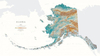
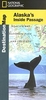
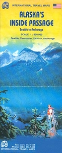
Alaska`s Inside Passage - Seattle To Anchorage ITMB

Alaska`s Inside Passage on a double-sided map from ITMB presenting the coastline of British Columbia and the panhandle at 1:900, 000, with the rest of the route at 1:1, 875, 000; plus large, clear street plans of central Seattle, Vancouver, Victoria and Anchorage.On one side is the area from Seattle to Prince Rupert BC, accompanied by street plans of central Seattle, Vancouver and Victoria. On the reverse mapping at 1:900, 000 continues along the panhandle to the Yukon Bay and the Malaspina Glacier, with an inset at 1:1, 875, 000 covering the coast further west to include the Kenai Peninsula and northwards beyond Anchorage to the Denali National Park. A second inset provides a street plan of central Anchorage. On both sides mapping at 1:900, 000 covers not just the immediate coastal
area but extends further inland, particularly in British Columbia where Whistler is included. Symbols indicate various places of interest including campsites. Maps at both scales have altitude colouring and spot heights (elevation shown in feet) with plenty of names of geographical features: islands, straights, sounds, bays and inlets, also mountain ranges, peaks, glaciers, etc. National parks and other protected areas are highlighted. Cruise and ferry route are marked and the maps also indicate local airports and airfields. Latitude and longitude lines are drawn at 1° and on the inset at 2° intervals. Each side has a separate index. Street plans are annotated with various facilities, including selected hotels, and places of interest.To see other regional titles from ITMB
covering USA please click on the series link.
RIP - This product is no longer available on our network. It was last seen on 25.09.2019

This page now acts as a permanent archive for this product. Add more information using the comments box below to ensure it can still be found by future generations.

Use our search facility to see if it is available from an alternative contributor.
  • Availability: Out Of Stock
  • Supplier: Stanfords
  • SKU: 9781553410904
Availability: In Stock
£9.99

Product Description

Alaska`s Inside Passage on a double-sided map from ITMB presenting the coastline of British Columbia & the panhandle at 1:900, 000, with the rest of the route at 1:1, 875, 000; plus large, clear street plans of central Seattle, Vancouver, Victoria & Anchorage. On one side is the area from Seattle to Prince Rupert BC, accompanied by street plans of central Seattle, Vancouver & Victoria. On the reverse mapping at 1:900, 000 continues along the panhandle to the Yukon Bay & the Malaspina Glacier, with an inset at 1:1, 875, 000 covering the coast further west to include the Kenai Peninsula & northwards beyond Anchorage to the Denali National Park. A second inset provides a street plan of central Anchorage. On both sides mapping at 1:900, 000 covers not just the immediate coastal area but extends further inl&, particularly in British Columbia where Whistler is included. Symbols indicate various places of interest including campsites. Maps at both scales have altitude colouring & spot heights (elevation shown in feet) with plenty of names of geographical

Features:
islands, straights, sounds, bays & inlets, also mountain ranges, peaks, glaciers, etc. National parks & other protected areas are highlighted. Cruise & ferry route are marked & the maps also indicate local airports & airfields. Latitude & longitude lines are drawn at 1° & on the inset at 2° intervals. Each side has a separate index. Street plans are annotated with various facilities, including selected hotels, & places of interest. To see other regional titles from ITMB covering USA please click on the series link.

Reviews/Comments

Add New

Intelligent Comparison

Oooops!
We couldn't find anything!
Perhaps this product's unique.... Or perhaps we are still looking for comparisons!
Click to bump this page and we'll hurry up.

Price History

Vouchers

No voucher codes found.
Do you know a voucher code for this product or supplier? Add it to Insights for others to use.

Facebook

Jargon Buster

Sounds - Audible notes that can be heard using ears
Large - something that takes up more space than normal.
Altitude - Something that can be quite high in relation to sea or ground level.
Regional - An adjective to describe a set geographic area.

Supplier Information

Stanfords
Stanfords was established in 1853 and opened their iconic Covent Garden flagship store in 1901. They have become the top retailer of maps, travel books and accessories in the UK and arguably offer the largest selection of maps and travel books worldwide. Famous names such as Captain Robert Falcon Scott, Ranulph Fiennes and Michael Palin have purchased from Stanfords. They now have a shop in Bristol and both stores together with other venues operate a calendar of events including talks, book signings and exhibitions. As a specialist map retailer, the map selection is comprehensive and includes road maps, street maps and walking maps from worldwide destinations, as well as a selection of world atlases and wall maps. Books include travel guides and travel literature. Stanfords also stock globes, from miniatures made of blue marble to magnificent floor-standing globes. The website features a selection of interesting articles on travel topics.
Page Updated: 2023-11-12 20:15:36

Community Generated Product Tags

Oh No! The productWIKI community hasn't generated any tags for this product yet!
Menu