More From Contributor
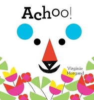
£9.99
Achensee
- Rofan
- Unterinntal area of the Austrian Alps north-east of Innsbruck presented at 1:50, 000 in a series of contoured

...
Archived Product
£13.99
Map No. 027, Achensee, printed on waterproof & tear-resistant sturdy plastic & with a panorama map on the reverse, in a series of hiking maps from Kompass providing extensive coverage of Austria & Germany plus the Slovenian Alps, with hiking routes on a topographic base, various types of accommodation, recreational facilities, places of interest, etc. Many titles are now published as competitively priced sets of two or more maps, offering a wider coverage. Kompass are Europe’s largest publishers of walking maps, with extensive coverage of hiking areas in other countries, all listed on our website. * Cartography:* all the maps are contoured with additional shading & graphic relief to provide a more detailed picture of the terrain, vegetation and/or land use. Contour interval varies from 10 metres in the coastal areas of Northern Germany to 40 or 50 metres in the mountainous parts of the two countries. All the maps highlight local & long-distance waymarked footpaths, including climbing trails. Most titles also show cycling routes, mountain bike trails, &, the in mountainous areas, ski routes. The maps indicate various types of accommodation (selected inns & hotels, youth hostels, campsites, mountain refuges), as well as recreational facilities, places of interest, etc. New editions also show access by public transport with bus stops and/or Park+ Ride facilities.* Geographical coordinates:* unless indicated to the contrary in the individual description, the maps have a UTM grid for GPS users. * Map legend:* most maps now include full English legend, particularly titles covering the Alpine areas. Some maps covering mainly eastern Austria or the less popular parts of Germany may still have a legend in German only.* Other
Features:* some titles now include on the reverse panorama drawings of their area with names of villages, peaks, valleys, etc. and/or have booklets with pictures of local wild flowers with their Latin names.*PLEASE NOTE BEFORE ORDERING!* * Booklets:* many titles come with booklets describing the area and/or various hiking routes. These booklets are in * German only*, apart from a handful of titles where an English language booklet is specifically indicated in the individual description. So, unless English language booklet is actually mentioned, the map can only be supplied with a German booklet. These booklets are not necessary to use the maps since, as stated above, most titles now include * full English language map legend.*
...
Archived Product
£8.50
Map No. 027, Achensee, with a panorama map on the reverse, in a series of hiking maps from Kompass providing extensive coverage of Austria & Germany plus the Slovenian Alps, with hiking routes on a topographic base, various types of accommodation, recreational facilities, places of interest, etc. Many titles are now published as competitively priced sets of two or more maps, offering a wider coverage. Kompass are Europe ...
Archived Product
£18.99
In July 2007, Lewis Gordon Pugh became the first person to swim at the North Pole, in temperatures that would kill a normal person, primarily to raise awareness of climate change. Nicknamed 'the human polar bear' for his ability to raise his body temperature at will, he has pioneered swims in the world's most hostile waters, redefining what it is possible to achieve in terms of endurance. A former member of the SAS, Lewis tells his fantastic story here for the first time. Chapters cover his childhood, growing up with his 'hero' Surgeon Rear Admiral father, his early life in South Africa, his gruelling training in the army's elite regiment, his inspiration &, of course, plenty of action/adventure stories, chronicling his many nail-biting endurance swims. With practical lessons taken from his own life, Lewis explains how recognising one's passions & taking calculated risks is essential for anyone looking to fulfil their goals. The book will also cover his expedition kayaking to the North Pole in summer 2008 & preparing for his most dangerous swim yet
- on Everest!
- planned for May 2010. His story is inspiring, entertaining & thrilling in equal measure, & its 39-year-old author is a much-needed role model for our times.

...
Archived Product
£1.99
Today we speak of an ` Achilles` heel`. But who was Achilles, & what exactly was the story of his heel? Why was he considered the finest hero in the Trojan War, & what caused him to fall out with King Agamemnon so that he refused to fight? Did he survive the war, or was he killed? All these questions are answered in this Put it in Your Pocket booklet, the fourth in a series of six on the Trojan War. ...
Archived Product
£9.99
Achterhoek region of the Netherlands at 1:50, 000 in a series from Falk B.V. showing the network of signposted cycling routes on large, double-sided indexed maps with prominent highlighting of long-distance LF routes, symbols indicating accommodation & other tourist services, plus in each title two or more panels with recommended local circuits & additional tourist information. The Falk 50K cycling series, which

Includes::
some adjoining areas in Lower Saxony & has now been extended to cover Flanders, shows the extensive network of sign-posted cycling routes. The network consists of numbered junctions joined by sign-posted connecting routes in either direction. At each junction there is an information panel showing an overview map of the whole network with the junction numbers. A second panel shows all the intersections directly connected to that junction. The system enables cyclists to plan their own routes by preparing a list of junction numbers through which they want to travel. Falk maps give cycling distances between the junctions & indicate which roads, both within the numbered network & outside it, have separate cycling paths. Routes which are part of the LF network of long-distance cycle routes are clearly marked. A wide range of symbols shows various accommodation options, bars & restaurants, & various places of interest. Landscape information is provided by colouring for woodlands, dunes, etc. The maps are indexed & show in the margins latitude & longitude at 1`52” intervals. Map legend

Includes::
English.PLEASE NOTE: to see other titles in the Falk series please click on the series link, where the series description

Includes::
a comparison between the Falk maps & the ANWB cycling series also covering the Netherlands at 1:50, 000.


...
Archived Product
£8.99
The Northern part of the Achterhoek Province of the Netherlands in a series of walking & cycling maps at 1:25, 000 – 1:35, 000, published by Falk BV in cooperation with Staatsbosbeheer – Dutch government’s organization for forestry & the management of nature reserves. Colouring indicates different types of vegetation or terrain: woodl&, pastures, heath or sand dunes. Given the topography of most of the country, the maps have no contour lines. The maps show local hiking trails, indicating their waymarking & include cycle paths & horse riding. Many local crossroads are annotated with the numbers of ANWB signposts & ‘mushrooms’ – a useful aid when navigating in Dutch countryside. Symbols indicate various tourist facilities & places of interest, including different types of accommodation, cafes, windmills, etc. The maps have no geographical coordinates. Map legend is in Dutch only. On the reverse each title has supplementary information, in Dutch only, about the region`s attractions. To see other titles in this series please click on the series link. ...
Archived Product
£8.99
The souther part of the Achterhoek Province of the Netherlands in a series of walking & cycling maps at 1:25, 000 – 1:35, 000, published by Falk BV in cooperation with Staatsbosbeheer – Dutch government’s organization for forestry & the management of nature reserves. Colouring indicates different types of vegetation or terrain: woodl&, pastures, heath or sand dunes. Given the topography of most of the country, the maps have no contour lines. The maps show local hiking trails, indicating their waymarking & include cycle paths & horse riding. Many local crossroads are annotated with the numbers of ANWB signposts & ‘mushrooms’ – a useful aid when navigating in Dutch countryside. Symbols indicate various tourist facilities & places of interest, including different types of accommodation, cafes, windmills, etc. The maps have no geographical coordinates. Map legend is in Dutch only. On the reverse each title has supplementary information, in Dutch only, about the region`s attractions. To see other titles in this series please click on the series link. ...
Archived Product
£9.50
Topographical survey of Belgium at 1:20, 000 from Nationaal Geografisch Instituut / Institut Géographique National, the country’s national survey organization. Each 20K map covers one quarter of the corresponding 1:50, 000 map (with adjustments in the border & coastal areas). The maps provide all the information expected of topographic mapping at this scale & in addition have an unusually large amount of vegetation and/or land use information (different types of woodlands, gardens, orchards, heath, etc). The maps have a 1-km UTM grid, with margin ticks for latitude & longitude at intervals of 1`. Map legend & a glossary of terms used on the maps include English. Stanfords keeps as regular stock 20K maps for the World War I battlefields around the Ypres, Messines & Passchendaele, & for the area of the Battle of Waterloo. The 1:20, 000 survey covers the whole of Belgium & maps for other regions can be supplied as special orders. To see the list of titles in this series please click on the series link.PLEASE NOTE: the Long-Distance Footpaths Map of Belgium at 1:300, 000 which shows the division of Belgium into the 50K survey sheets can also be used to see in more detail coverage by the 20K maps. ...
Archived Product
£3.50
Acocks Green in 1902-1911 in a fascinating series of reproductions of old Ordnance Survey plans in the Alan Godfrey Editions, ideal for anyone interested in the history of their neighbourhood or family. The map covers the village of Acock`s Green, east of Birmingham, at the time when it was growing into a substantial suburb. Coverage stretches from Knight`s Road eastward to Lyndon Farm & the county boundary, & from the cemetery southward to Botteville Road. Features include GWR railway with Acock`s Green station, part of Tyseley, Stockfield, Cottsbrook House, Warwick & Birmingham Canal, nursery, allotments, St Mary`s church, Pioneer Cabinet Works, Tyseley Farm, Stockfield Hall, cycle accessory works, Redstone Farm. The route of the new GWR line towards Stratford is shown but not the track. On the reverse are street directory entries for Alexander Road, Arden Road, Augusta Road, The Avenue, Bottville Road, Broad Road, Flint Green Road, Florence Road, Oxford Road, Sherbourne Road, Warwick Road & Yardley Road. The map is taken from the interesting ` Inland Revenue Special Edition`, a survey of 1902 but with partial revision to 1911. Although the publishers have given the map its Warwickshire sheet number, it also serves as Worcestershire sheet 6.15. About the Alan Godfrey Editions of the 25” OS Series: Selected towns in Great Britain & Ireland are covered by maps showing the extent of urban development in the last decades of the 19th & early 20th century. The plans have been taken from the Ordnance Survey mapping & reprinted at about 15 inches to one mile (1:4, 340). On the reverse most maps have historical notes & many also include extracts from contemporary directories. Most maps cover about one mile (1.6kms) north/south, one & a half miles (2.4kms) across; adjoining sheets can be combined to provide wider coverage.FOR MORE INFORMATION & A COMPLETE LIST OF ALL AVAILABLE TITLES PLEASE CLICK ON THE SERIES LINK. ...
Archived Product

Achoo!

It`s spring and the animals in the forest can`t stop sneezing. But something surprising happens each time an animal says achoo! After sniffing a flower blue bear sneezes, and his round blue ears fly to the next page, where fox mistakes them for blueberries. But before fox knows it, ”Achoo!”, his triangular ears are also soaring over the page to be found by another animal. At the end of the book, we see how each animal has sneezed their way to a completely new look! Filled with humour, Achoo! is an entertaining introduction to shapes and colours.
RIP - This product is no longer available on our network. It was last seen on 25.09.2019

This page now acts as a permanent archive for this product. Add more information using the comments box below to ensure it can still be found by future generations.

Use our search facility to see if it is available from an alternative contributor.
  • External links may include paid for promotion
  • Availability: Out Of Stock
  • Supplier: Stanfords
  • SKU: 9781849763769
Availability: In Stock
£9.99

Product Description

It`s spring & the animals in the forest can`t stop sneezing. But something surprising happens each time an animal says achoo! After sniffing a flower blue bear sneezes, & his round blue ears fly to the next page, where fox mistakes them for blueberries. But before fox knows it, ” Achoo!”, his triangular ears are also soaring over the page to be found by another animal. At the end of the book, we see how each animal has sneezed their way to a completely new look! Filled with humour, Achoo! is an entertaining introduction to shapes & colours.

Reviews/Comments

Add New

Intelligent Comparison

Oooops!
We couldn't find anything!
Perhaps this product's unique.... Or perhaps we are still looking for comparisons!
Click to bump this page and we'll hurry up.

Price History

Vouchers

No voucher codes found.
Do you know a voucher code for this product or supplier? Add it to Insights for others to use.

Facebook

Jargon Buster

Forest - A area with a high density of trees
Blue - A primary colour
Humour - Something either verbal of physical that provides amusement and can provoke laughter
Flower - The reproductive part of a plant. Colourful to attract insects to pollenate
Flower - A product that comes from planting a seed, tend to be the brightly coloured part at the end of the stem.

Supplier Information

Stanfords
Stanfords was established in 1853 and opened their iconic Covent Garden flagship store in 1901. They have become the top retailer of maps, travel books and accessories in the UK and arguably offer the largest selection of maps and travel books worldwide. Famous names such as Captain Robert Falcon Scott, Ranulph Fiennes and Michael Palin have purchased from Stanfords. They now have a shop in Bristol and both stores together with other venues operate a calendar of events including talks, book signings and exhibitions. As a specialist map retailer, the map selection is comprehensive and includes road maps, street maps and walking maps from worldwide destinations, as well as a selection of world atlases and wall maps. Books include travel guides and travel literature. Stanfords also stock globes, from miniatures made of blue marble to magnificent floor-standing globes. The website features a selection of interesting articles on travel topics.
Page Updated: 2023-11-12 20:15:36

Community Generated Product Tags

Oh No! The productWIKI community hasn't generated any tags for this product yet!
Menu