
 United Kingdom
 France
 Germany
 Netherlands
 Sweden
 USA
USA
 Italy
Italy
 Spain
Spain
More From Contributor


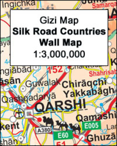
Silk Road Countries Wall Map
The Silk Route Countries Wall Map at 1:3, 000, 000 from Gizi Map, size 124 x 87cm (49” x 34” approx), with coverage extending from eastern Turkey and Syria, across the countries of Central Asia, to western China and south to the Arabian Sea; different variants of the route across this vast region are clearly highlighted.The map has altitude coloring to provide an excellent picture of the topography, with names of mountain ranges, deserts and other geographical features, numerous spot heights and peak names, swamps and salt flats, glaciers, etc. National parks, world heritage sites and other historical monuments are highlighted. The regions’ rail and road networks are shown, including dirt tracks, and driving distances are marked on major roads. The map also indicates
local administrative boundaries and names of provinces in various countries. All place names are transliterated, with alternative versions provided where necessary, particularly in the border areas. Lines of latitude and longitude are drawn at 2° intervals. Map legend includes English. Index of localities is on the reverse of the map.PLEASE NOTE: this title is also available in a folded format.
local administrative boundaries and names of provinces in various countries. All place names are transliterated, with alternative versions provided where necessary, particularly in the border areas. Lines of latitude and longitude are drawn at 2° intervals. Map legend includes English. Index of localities is on the reverse of the map.PLEASE NOTE: this title is also available in a folded format.

Product Description
Reviews/Comments
Add New
Vouchers
No voucher codes found.
Do you know a voucher code for this product or supplier? Add it to Insights for others to use.
Do you know a voucher code for this product or supplier? Add it to Insights for others to use.
 Denmark