More From Contributor
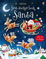
£6.50
Topographic coverage of the Balearic Islands at 1:25, 000 published by the Instituto Geográfico Nacional – Centro Nacional de Información Geografica, the country’s civilian survey organization. The maps have contours at 10m intervals & colouring and/or graphics to show different types of vegetation or land use. Boundaries of national parks & other protected areas are marked. In addition to all the usual information shown on topographic mapping at this scale: detailed presentation of the road & rail networks, rural tracks & paths, etc, the maps also show campsites. The maps have a 1-km UTM grid, plus margin ticks for latitude & longitude at 1` intervals. The majority of the titles have been published since late 1990s. Map legend is in Spanish only.COVERAGE: each 25K map covers one quarter of the corresponding 1:50, 000 map, with the numbering system: I = NW quarter, II = NE quarter, III = SW quarter, & IV = SE quarter. To see other titles in this series please click on the series link. ...
Archived Product
£14.99
Sant Maurici area of the Spanish Pyrenees, including the eastern half of the Aigüestortes i Estany de Sant Maurici National Park, presented on a contoured & GPS compatible map at 1:25, 000 from Editorial Alpina. The map has contours at 10m intervals, enhanced by relief shading with plenty of spot heights, plus colouring for different types of vegetation and/or land use. An overprint highlights walking paths, indicating where appropriate their PR or GR numbers. Symbols show various types of accommodation (hotels, farms, refuges, campsites, etc), picturesque locations & other places of interest. The map has a 1km UTM grid plus latitude & longitude margin ticks at 1’ intervals. Map legend

Includes::
English. Accompanying booklet with 28 pages in English provides descriptions of several recommended walking trails & of more strenuous ascents. Also included is a list of contact details for local accommodation.PLEASE NOTE: this title is also available as part of a 2-map set “ Aigüestortes i Estany de Sant Maurici National Park”, combined with the Vall de Boi map covering the western part of the park; the set contains just the two maps, without the booklets which accompany them when sold separately. To see the list of currently available titles in this extensive Editorial Alpina hiking series please click on the series link.

...
Archived Product
£6.50
Topographic coverage of the Balearic Islands at 1:25, 000 published by the Instituto Geográfico Nacional – Centro Nacional de Información Geografica, the country’s civilian survey organization. The maps have contours at 10m intervals & colouring and/or graphics to show different types of vegetation or land use. Boundaries of national parks & other protected areas are marked. In addition to all the usual information shown on topographic mapping at this scale: detailed presentation of the road & rail networks, rural tracks & paths, etc, the maps also show campsites. The maps have a 1-km UTM grid, plus margin ticks for latitude & longitude at 1` intervals. The majority of the titles have been published since late 1990s. Map legend is in Spanish only.COVERAGE: each 25K map covers one quarter of the corresponding 1:50, 000 map, with the numbering system: I = NW quarter, II = NE quarter, III = SW quarter, & IV = SE quarter. To see other titles in this series please click on the series link. ...
Archived Product
£6.95
Topographic coverage of the Balearic Islands at 1:50, 000 in the MTN50 (Mapa Topográfico Nacional) series from the Instituto Geográfico Nacional – Centro Nacional de Información Geografica, the country’s civilian survey organization. The maps have contours at 20m intervals, enhanced by relief shading, plus colouring and/or graphics to show different types of terrain, vegetation or land use. Boundaries of national parks & other protected areas are marked. In addition to all the usual information featured on topographic mapping at this scale: detailed presentation of the road & rail networks, rural tracks & paths, etc, the maps also show campsites & mountain refuges. On more recent editions some GRs, the official long-distance hiking routes, are also marked (although not as clearly as on hiking maps from other publishers). The MTN50 series was begun in late 1990s. Each map covers 28.5x 18.5 km (with adjustments in the coastal areas). The maps have a 1-km UTM grid, plus margin ticks for latitude & longitude at 1` intervals. Map legend is in Spanish only. To see other titles in this series please click on the series link. ...
Archived Product
£6.50
Topographic coverage of the Balearic Islands at 1:25, 000 published by the Instituto Geográfico Nacional – Centro Nacional de Información Geografica, the country’s civilian survey organization. The maps have contours at 10m intervals & colouring and/or graphics to show different types of vegetation or land use. Boundaries of national parks & other protected areas are marked. In addition to all the usual information shown on topographic mapping at this scale: detailed presentation of the road & rail networks, rural tracks & paths, etc, the maps also show campsites. The maps have a 1-km UTM grid, plus margin ticks for latitude & longitude at 1` intervals. The majority of the titles have been published since late 1990s. Map legend is in Spanish only.COVERAGE: each 25K map covers one quarter of the corresponding 1:50, 000 map, with the numbering system: I = NW quarter, II = NE quarter, III = SW quarter, & IV = SE quarter. To see other titles in this series please click on the series link. ...
Archived Product
£9.99
The beautiful Glitter Christmas Greetings Cards by Cavallini & Co. feature Father Christmas vintage image & Merry Christmas print. Packed in a stylish silver tin, the 12 postcards come in 6 different designs, each measuring 10x 14.5 cm. Add magic sparkles to your Christmas greetings. ...
Archived Product
£7.50
Santa Barbara in California on an indexed street plan from GM Johnson & Associates, including enlargement for the downtown area & coverage of Buellton – Solvang, Carpinteria, Goleta, Guadalupe, Santa Maria, Lompoc, Los Alamos & the Vandenberg Air Force Base. The street plans are presented in different panels & show selected streets annotated with block numbers for easier identification of addresses. Colouring indicates land use (shopping centre, university, park, etc), & various facilities and/or places of interest are highlighted. One index covers all the different locations. Downtown Santa Barbara is shown in greater detail on an enlargement & also provided a road map of the Santa Barbara County indicating which areas are covered by the panels with street plans. ...
Archived Product
£7.95
The Santa Barbara, San Luis Obispo & Paso Robles Wine Country Map presents the wine growing region north of Santa Barbara on a detailed, laminated concertina road map, with lists of over 200 wineries & 11 tasting rooms, all with addresses & opening times. On one side is a detailed road map showing boundaries & names of the viticultural areas & annotated with names of individual vineyards or wineries & tasting rooms. On the reverse over 200 wineries are listed with their opening times, indicating whether opened for tasting only or also for tours. There is also list of 11 tasting rooms. ...
Archived Product
£6.50
Topographic coverage of the Canary Islands at 1:25, 000 published by the Instituto Geográfico Nacional – Centro Nacional de Información Geografica, the country’s civilian survey organization. The maps have contours at 10m intervals & colouring and/or graphics to show different types of vegetation or land use. Boundaries of national parks & other protected areas are marked. In addition to all the usual information shown on topographic mapping at this scale: detailed presentation of the road network with rural tracks & paths, etc, the maps also show campsites. The maps have a 1-km UTM grid, plus margin ticks for latitude & longitude at 1` intervals. The majority of the titles have been published since late 1990s. Map legend is in Spanish only.COVERAGE: each 25K map covers one quarter of the corresponding 1:50, 000 map, with the numbering system: I = NW quarter, II = NE quarter, III = SW quarter, & IV = SE quarter. To see other titles in this series please click on the series link. ...
Archived Product

Santa

A perfect activity book for Christmas; little children will love adding stickers to the magical festive scenes and bringing them to life. Scenes include Santa getting ready, flying in his sleigh and delivering presents. With over 150 stickers. WARNING! Not suitable for children under 36 months because of small parts. Choking Hazard.
RIP - This product is no longer available on our network. It was last seen on 25.09.2019

This page now acts as a permanent archive for this product. Add more information using the comments box below to ensure it can still be found by future generations.

Use our search facility to see if it is available from an alternative contributor.
  • External links may include paid for promotion
  • Availability: Out Of Stock
  • Supplier: Stanfords
  • SKU: 9781409534921
Availability: In Stock
£4.99

Product Description

A perfect activity book for Christmas; little children will love adding stickers to the magical festive scenes & bringing them to life. Scenes include Santa getting ready, flying in his sleigh & delivering presents. With over 150 stickers. WARNING! Not suitable for children under 36 months because of small parts. Choking Hazard.

Reviews/Comments

Add New

Intelligent Comparison

Oooops!
We couldn't find anything!
Perhaps this product's unique.... Or perhaps we are still looking for comparisons!
Click to bump this page and we'll hurry up.

Price History

Vouchers

No voucher codes found.
Do you know a voucher code for this product or supplier? Add it to Insights for others to use.

Facebook

Jargon Buster

Santa - Also known as Santa Claus is a legendary figure believed to bring gifts to good children on the night of Christmas Eve / Christmas Day
Love - Someone who shows deep affection for someone else.
Small - something that takes up less space than normal.
Children - A young life form within the early stages of physical development,

Supplier Information

Stanfords
Stanfords was established in 1853 and opened their iconic Covent Garden flagship store in 1901. They have become the top retailer of maps, travel books and accessories in the UK and arguably offer the largest selection of maps and travel books worldwide. Famous names such as Captain Robert Falcon Scott, Ranulph Fiennes and Michael Palin have purchased from Stanfords. They now have a shop in Bristol and both stores together with other venues operate a calendar of events including talks, book signings and exhibitions. As a specialist map retailer, the map selection is comprehensive and includes road maps, street maps and walking maps from worldwide destinations, as well as a selection of world atlases and wall maps. Books include travel guides and travel literature. Stanfords also stock globes, from miniatures made of blue marble to magnificent floor-standing globes. The website features a selection of interesting articles on travel topics.
Page Updated: 2023-11-12 20:15:36

Community Generated Product Tags

Oh No! The productWIKI community hasn't generated any tags for this product yet!
Menu