More From Contributor
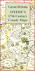
£5.95
Herefordshire in a series of colourful reproductions of attractive county maps by John Speede from about 1610-1611, printed on thick art paper & ideal for framing. Each title, 58 x 45cm / approx. 23” x 18”, is decorated with additional notes, drawings, coats of arms, street plans, etc. Little drawings are used to show locations of towns, larger villages, hills & woodlands or parks. Rivers & lakes are also drawn, as are boundaries of the administrative subdivisions with the names of the Hundreds. Surrounding the county are decorative panels filled with additional information which differs from title to title: street plans, coats of arms of notable local families, geographical features, notes about local history, etc. ...
Archived Product
£9.99
Herefordshire & Worcestershire in the AA 50 Walks series; comprising an extensive range of walking guides helping you to explore the best walking routes in Great Britain. Each guide covers a total of 50 walks, many of which are circular, between 2-10 miles & also that are suitable for a range of different walking standards. Every walk in the guides has an information box showing clear details of distance, minimum time, level of difficulty, any ascents, the nature of the terrain & landscape, suggested Ordnance Survey map, grid references for starting & finishing points, dog friendliness, parking & any public toilets en route. There are also suggestions of what to look out for & recommended places to eat & drink. Detailed walk descriptions are accompanied by clear mapping of the route ahead, in addition to colour photographs illustrating the highlights of selected routes. ...
Archived Product
£11.99
Walking is one of Britain`s favourite leisure activities, & this fantastic walking guide to Herefordshire & Worcestershire features a variety of mapped walks to suit all abilities. The book features all the practical detail you need, accompanied by fascinating background reading on the history & wildlife of the area, as well as other local points of interest. All walks are annotated with local points of interest & places to stop for refreshments & every walk is given a summary of distance, time, gradient, level of difficulty, type of surface & access, landscape, dog friendliness, parking & public toilets. ...
Archived Product
£6.99
Herefordshire & The Wye Valley in the Short Walks guide series, produced in association with Ordnance Survey & published by Crimson; comprising a range of walking guides to popular British destinations. Each title

Includes::
20 varied walks that are suitable for walkers of all ages & abilities & is accompanied by detailed Explorer 1:25, 000 Ordnance Survey mapping with colour-coded marked routes. The guides are structured in three main sections with different levels of difficulty- short & easy walks, those of modest length that may include uphill walking & more challenging routes that may be longer & over more rugged terrain- covering a total of 20 walks. Each walk has a mini summary & an information box with details of starting points, distance, approximate time, parking & any individual route features. There is also information on refreshments, local transport & public toilets en route. Appendices provide further useful information on walking safety, GPS, the Countryside Code, local organisations & Ordnance Survey maps.

...
Archived Product
£2.95
Herefordshire 1610 Replica Map by the Old Map Company is a reproduction of the map created for the famous atlas of the period by the master map maker John Speede Esq. The Old Map Company has recreated the antique maps of British counties, European cities & World countries originally crafted by master map maker John Speede Esq. whose work had accuracy & quality not surpassed for centuries. Each map is treated & presented on specially crafted paper then h&-treated giving it texture & an aged appearance before being beautifully engraved & detailed. ...
Archived Product
£100.00
A Map of Herefordshire, an original antique map by E. Bowen / J. Owen, published in London, c. 1720 -1730. A copperplate engraving, coloured. Map size 11 x 11 cm with a mount size of 26.5 x 32.5 cm. Emanuel Bowen was one of the most prolific map engravers active in London in the mid-eighteenth century. Beginning his career in about 1714 he continued into the 1760s producing maps of all parts of Britain & the world. In fact, few other mapmakers of any period could lay claim to such a broad output; from maps or plans of localised British regions & counties, to maps of almost unknown regions such as Australia & the North Pole! Bowen's maps appeared in atlases, travel & history books, periodicals & as separate publications. However, despite the quantity of work, many of his maps have an important place in cartography
- most notably the large-scale county maps designed with Thomas Kitchin. Undoubtedly, one of the most popular atlases of the early eighteenth century was that with maps engraved by Bowen for John Owen's Britannia Depicta
- a pocket-sized atlas of county maps & strip road maps, based on John Ogilby's famous road book of 1675, & first published in 1720. The maps include, within decorated cartouches, information regarding market days, distances & such like pertaining to the county shown. Antique maps from various original publishers are presented on the Stanford

...
Archived Product
£80.00
A Map of Hereford Shire, an original antique map by E. Bowen / J. Owen, published in London, 1720 -1724. A copperplate engraving, coloured. Map size 11.5 x 18 cm with a mount size of 26 x 33 cm. Emanuel Bowen was one of the most prolific map engravers active in London in the mid-eighteenth century. Beginning his career in about 1714 he continued into the 1760's producing maps of all parts of Britain & the world. In fact, few other mapmakers of any period could lay claim to such a broad output, from maps or plans of localised British regions & counties, to maps of almost unknown regions such as Australia & the North Pole! Bowen's maps appeared in atlases, travel & history books, periodicals & as separate publications. However, despite the quantity of work, many of his maps have an important place in cartography
- most notably the large-scale county maps designed with Thomas Kitchin. Undoubtedly one of the most popular atlases of the early eighteenth century was that with maps engraved by Bowen for John Owen's Britannia Depicta
- a pocket-sized atlas of county maps & strip road maps, based on John Ogilby's famous road book of 1675, & first published in 1720. This particular map comes from a 1724 edition of the Britannia Depicta & is immensely detailed & finely engraved with a decorated cartouche, information regarding market days & distances pertaining to the county shown. Antique maps from various original publishers are presented on the Stanford

...
Archived Product
£60.00
Herefordshire, an original antique map by G. Cole / J. Roper published in London, 1810-1843. Copperplate, coloured. Map size 17 x 23 cm, overall mounted size 32.5 x 38.5 cm. This detailed map of Herefordshire is from Dugdale's England & Wales Delineated. The map was drawn by G. Cole & engraved by John Roper for publication first in The Beauties Of England & Wales, issued in parts, from c.1804. Such was the success of the publication that the maps were re-used in other publications, as here. The maps show accurate geographical detail, including the turnpike, mail coach & principal roads, sites of Roman & other historical remains, as well as the seats of the nobility & the gentry, & market towns with their distances from London. The maps also show the division of the counties into hundreds or wapontakes. They are representative of the functional nineteenth-century approach to cartography, yet are not unattractive. Antique maps from various original publishers are presented on the Stanford ...
Archived Product
£120.00
Herefordshire, an original antique map by R. Ramble, published in London, 1821 -1844. A lithograph engraving, original colour. Map size 15 x 18.5 cm with a mount size of 29.5 x 33.5 cm. An attractive & uncommon miniature map surrounded by vignettes of the county's landmarks including Hereford Cathedral & Ross on Wye. Ramble added these vignettes to Miller's maps of 1821 that were originally published as part of Miller's New Miniature Atlas.. .. With the decorative views added these maps were republished from 1844 in Reuben Ramble's Travels Through The Counties Of England
- a child's guide to the country. Protective right margin added. Antique maps from various original publishers are presented on the Stanford
...
Archived Product
£80.00
Herefordshire, an original antique map by G. Cole / J. Roper, published in London, c. 1804 -1810. A copperplate engraving, original colour. Map size 17.5 x 23 cm with a mount size of 32.5 x 38.5 cm.A detailed nineteenth-century map of Herefordshire that was published in the atlas, The British Atlas; Comprising A Complete Set Of County Maps, Of England & Wales; & Plans Of Cities & Principal Towns in 1810. The map was drawn by G. Cole & engraved by John Roper for publication in The Beauties Of England & Wales, that was published in parts, from c.1804. Such was the success of the publication that the maps were re-used in other publications, as here. The maps show accurate geographical detail, including the turnpike, mail coach & principal roads, sites of Roman & other historical remains, as well as the seats of the nobility & the gentry, & market towns with their distances from London. The maps also show the division of the counties into hundreds or wapontakes. They are representative of the functional nineteenth-century approach to cartography, yet are not unattractive. Antique maps from various original publishers are presented on the Stanford ...
Archived Product

Herefordshire 1627

Hereford Shire, an original antique map by P.Van Den Keere, published in London, 1627 -1666. A copperplate engraving, coloured. Map size 12 x 8.5 cm with a mount size of 26.5 x 22.5 cm.Pieter van den Keere (1571-1646) was an active Dutch engraver best known for his collection of pocket-sized maps of the British Isles, assembled in about 1605. The maps, reprinted by Willem Blaeu in 1617, were subsequently acquired by Speed's publisher George Humble in c.1620. Those plates which showed separate counties were re-engraved, with the titles now in English, and plate numbers added. For those counties previously combined on one sheet, Humble substituted new plates, depicting the counties separately. The atlas was known as the miniature-Speed and was frequently reprinted, from 1627
onwards, often to coincide with folio editions of Speed's maps. Van den Keere also engraved the plates for the miniature edition of Speed's Prospect, published in 1646. Van den Keere - often known as Kaerius - also engraved a large number of foreign maps at miniature, quarto and folio sizes and his plates were, in some cases, re-published well into the eighteenth century. This map is from a 1666 edition of the so-called miniature-Speed and shows the county of Herefordshire. Antique maps from various original publishers are presented on the Stanford
RIP - This product is no longer available on our network. It was last seen on 25.09.2019

This page now acts as a permanent archive for this product. Add more information using the comments box below to ensure it can still be found by future generations.

Use our search facility to see if it is available from an alternative contributor.
  • External links may include paid for promotion
  • Availability: Out Of Stock
  • Supplier: Stanfords
  • SKU: XL950654
Availability: In Stock
£120.00

Product Description

Hereford Shire, an original antique map by P. Van Den Keere, published in London, 1627 -1666. A copperplate engraving, coloured. Map size 12 x 8.5 cm with a mount size of 26.5 x 22.5 cm. Pieter van den Keere (1571-1646) was an active Dutch engraver best known for his collection of pocket-sized maps of the British Isles, assembled in about 1605. The maps, reprinted by Willem Blaeu in 1617, were subsequently acquired by Speed's publisher George Humble in c.1620. Those plates which showed separate counties were re-engraved, with the titles now in English, & plate numbers added. For those counties previously combined on one sheet, Humble substituted new plates, depicting the counties separately. The atlas was known as the miniature-Speed & was frequently reprinted, from 1627 onwards, often to coincide with folio editions of Speed's maps. Van den Keere also engraved the plates for the miniature edition of Speed's Prospect, published in 1646. Van den Keere
- often known as Kaerius
- also engraved a large number of foreign maps at miniature, quarto & folio sizes & his plates were, in some cases, re-published well into the eighteenth century. This map is from a 1666 edition of the so-called miniature-Speed & shows the county of Herefordshire. Antique maps from various original publishers are presented on the Stanford

Reviews/Comments

Add New

Intelligent Comparison

Oooops!
We couldn't find anything!
Perhaps this product's unique.... Or perhaps we are still looking for comparisons!
Click to bump this page and we'll hurry up.

Price History

Vouchers

No voucher codes found.
Do you know a voucher code for this product or supplier? Add it to Insights for others to use.

Facebook

Jargon Buster

Cm - Centimetres, one centimetre is equal to 10 milimetres
antique - An old collectible item with desirable qualities.
speed - A measurement of how fast an object travels between two points
Size - is the measurement of how big an object is in space.
Large - something that takes up more space than normal.
Pocket - A bag shaped insert in clothing used to carry items

Supplier Information

Stanfords
Stanfords was established in 1853 and opened their iconic Covent Garden flagship store in 1901. They have become the top retailer of maps, travel books and accessories in the UK and arguably offer the largest selection of maps and travel books worldwide. Famous names such as Captain Robert Falcon Scott, Ranulph Fiennes and Michael Palin have purchased from Stanfords. They now have a shop in Bristol and both stores together with other venues operate a calendar of events including talks, book signings and exhibitions. As a specialist map retailer, the map selection is comprehensive and includes road maps, street maps and walking maps from worldwide destinations, as well as a selection of world atlases and wall maps. Books include travel guides and travel literature. Stanfords also stock globes, from miniatures made of blue marble to magnificent floor-standing globes. The website features a selection of interesting articles on travel topics.
Page Updated: 2023-11-12 20:15:36

Community Generated Product Tags

Oh No! The productWIKI community hasn't generated any tags for this product yet!
Menu