More From Contributor

£9.99
This double-sided geophysical & glaciological map shows the basal topography of Greenland & surrounding seabed. The topography of the subglacial landscape under the Greenland Icesheet was modelled using a mixture of radio echo-sounding & a glaciological model (BEDMACHINE 2) & is presented in a similar colour scheme to the Antarctic BEDMAP2. The map is a result of a collaboration between BAS & Bristol University, based on recently released data from a joint project between Bristol University & the University of Irvine California.
- Side 1 shows a detailed map, in plan view, &

Includes::
important names, coastline & the zero metre contour.
- Side 2 presents a 3D view of the dataset, highlighting some of the important & interesting features & gives further details of how the surface was constructed.


...
Archived Product
£29.99
Topographic survey of Greenland at 1:250, 000 from Sagamaps in a series which along the western coast extends past Thule to the latitude of 78°, plus covers selected areas of the east coast including the Stauning Alps. Relief is shown by contours at 50m intervals, augmented by frequent spot heights. Main peaks are named, along with many other physical features, e.g. bays & islands. Glaciers, moraine & low-lying coastal plains are also indicated & contours continue for a limited extent into the icecap region. The maps show settlements, roads, airstrips & heliports, anchorages & selected other landmarks. Lines of longitude & latitude are drawn at 1° & 15` intervals respectively. Map legend which

Includes::
English is provided in a separate sheet. Saga’s topographic mapping of Greenland at 1:250, 000 is available either as 22 smaller sheets, sold separately or in sets of four maps, plus as three larger maps covering the western coast up to approx 65°. Selected titles are also published with a historical guide on the reverse illustrated with old photos, drawings & maps; all the text is in English. To see the full list of titles in this series please click on the series link.

...
Archived Product
£11.50
Greenland at 1:1, 900, 000 on a double-sided, indexed, waterproof & tear-resistant map from Reise Know-How with plenty of topographic information, ferry & air connections, highlighting for places of interest, routes of cross- Greenland expeditions, etc. The map divides Greenland north/south with a good overlap between the sides & presents Greenland’s topography by altitude colouring in bands of 500 metres & numerous spot heights, plus plenty of names of mountain ranges, peaks, glaciers, coastal bays & fjords, etc. Current Greenlandic names are used with, where appropriate, the previous Danish names also shown (Nuuk / Godthab, Pituffik / Thule, etc). The map shows ferry lines along the south-western coastline, airfields, aerodromes & heliports, locations with hotels, various places of interest including whale watching sites, etc. Also marked are internal administrative boundaries, the boundary of the North-East Greenland National Park, & the routes of various cross-Greenland expeditions in the early decades of the 20th century. The map has an index of settlements & shows latitude lines at 2° intervals, with longitude lines at 3°. Map legend

Includes::
English. An inset provides a map of the North Atlantic, showing Greenland with most of Western Europe including Svalbard, & the north-eastern coast of North America from New York to Canada’s Arctic islands.

...
Archived Product
£44.99
This 120x 72cm large wallmap clearly shows the difference between Greenland`s ice-free coastal areas & the icy interior. The interior shows only contours at 500m intervals. The coast, however, is shown by elevations tinting (i.e. different colours for different altitudes) & spot heights. Towns & settlements are clearly marked, as are fjords, sounds, airports & hydro-electric plants. National parks & administrative boundaries are shown. Lines of latitude & longitude are shown. ...
Archived Product
£29.99
Topographic survey of Greenland at 1:250, 000 from Sagamaps in a series which along the western coast extends past Thule to the latitude of 78°, plus covers selected areas of the east coast including the Stauning Alps. Relief is shown by contours at 50m intervals, augmented by frequent spot heights. Main peaks are named, along with many other physical features, e.g. bays & islands. Glaciers, moraine & low-lying coastal plains are also indicated & contours continue for a limited extent into the icecap region. The maps show settlements, roads, airstrips & heliports, anchorages & selected other landmarks. Lines of longitude & latitude are drawn at 1° & 15` intervals respectively. Map legend which

Includes::
English is provided in a separate sheet. Saga’s topographic mapping of Greenland at 1:250, 000 is available either as 22 smaller sheets, sold separately or in sets of four maps, plus as three larger maps covering the western coast up to approx 65°. Selected titles are also published with a historical guide on the reverse illustrated with old photos, drawings & maps; all the text is in English. To see the full list of titles in this series please click on the series link.

...
Archived Product
£11.95
Map No. C-1 in the ONC series: military topographic survey mapping covering the world's land masses & significant islands at 1:1, 000, 000. The maps are useful as general topographical coverage where nothing else is available, although they are designed primarily as flying charts for military aircraft. ONC stands for Operational Navigation Chart. Relief is portrayed by a combination of contours (basic interval 1000ft, intermediate contours shown where appropriate), elevation tinting & relief shading, plus spot heights. Towns, villages, major roads, railways & airports are shown but please note that many of the smaller settlements are not named & the road information is not necessarily up to date, as compilation & revision dates vary. Some air navigation information also appears on the map, such as radio beacons & restricted flying zones. Each ONC chart has both UTM & latitude/longitude grids overprinted on it, with additional margin ticks. IMPORTANT
- PLEASE NOTE: The series is gradually being withdrawn from sale to the general public & some sheets may no longer be available when ordered by us. Due to the nature of the map projection assembling these sheets to make a larger map is not recommended. in addition, colours used for relief are not constant throughout the series. In some areas of central Africa & South America the maps have blank spaces, reflecting localized deficiencies or inconsistencies in the survey data.
...
Archived Product
£11.95
Map No. C-13 in the ONC series: military topographic survey mapping covering the world's land masses & significant islands at 1:1, 000, 000. The maps are useful as general topographical coverage where nothing else is available, although they are designed primarily as flying charts for military aircraft. ONC stands for Operational Navigation Chart. Relief is portrayed by a combination of contours (basic interval 1000ft, intermediate contours shown where appropriate), elevation tinting & relief shading, plus spot heights. Towns, villages, major roads, railways & airports are shown but please note that many of the smaller settlements are not named & the road information is not necessarily up to date, as compilation & revision dates vary. Some air navigation information also appears on the map, such as radio beacons & restricted flying zones. Each ONC chart has both UTM & latitude/longitude grids overprinted on it, with additional margin ticks. IMPORTANT
- PLEASE NOTE: The series is gradually being withdrawn from sale to the general public & some sheets may no longer be available when ordered by us. Due to the nature of the map projection assembling these sheets to make a larger map is not recommended. in addition, colours used for relief are not constant throughout the series. In some areas of central Africa & South America the maps have blank spaces, reflecting localized deficiencies or inconsistencies in the survey data.
...
Archived Product

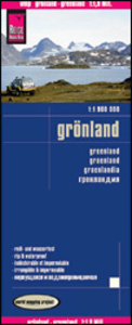
Greenland Reise Know-How

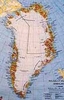
Greenland at 1:1, 900, 000 on a double-sided, indexed, waterproof and tear-resistant map from Reise Know-How with plenty of topographic information, ferry and air connections, highlighting for places of interest, routes of cross- Greenland expeditions, etc.The map divides Greenland north/south with a good overlap between the sides and presents Greenland’s topography by altitude colouring in bands of 500 metres and numerous spot heights, plus plenty of names of mountain ranges, peaks, glaciers, coastal bays and fjords, etc. Current Greenlandic names are used with, where appropriate, the previous Danish names also shown (Nuuk / Godthab, Pituffik / Thule, etc).The map shows ferry lines along the south-western coastline, airfields, aerodromes and heliports, locations with
hotels, various places of interest including whale watching sites, etc. Also marked are internal administrative boundaries, the boundary of the North-East Greenland National Park, and the routes of various cross-Greenland expeditions in the early decades of the 20th century. The map has an index of settlements and shows latitude lines at 2° intervals, with longitude lines at 3°. Map legend includes English.An inset provides a map of the North Atlantic, showing Greenland with most of Western Europe including Svalbard, and the north-eastern coast of North America from New York to Canada’s Arctic islands.
RIP - This product is no longer available on our network. It was last seen on 25.09.2019

This page now acts as a permanent archive for this product. Add more information using the comments box below to ensure it can still be found by future generations.

Use our search facility to see if it is available from an alternative contributor.
  • External links may include paid for promotion
  • Availability: Out Of Stock
  • Supplier: Stanfords
  • SKU: 9783831772575
Availability: In Stock
£7.50

Product Description

Greenland at 1:1, 900, 000 on a double-sided, indexed, waterproof & tear-resistant map from Reise Know-How with plenty of topographic information, ferry & air connections, highlighting for places of interest, routes of cross- Greenland expeditions, etc. The map divides Greenland north/south with a good overlap between the sides & presents Greenland’s topography by altitude colouring in bands of 500 metres & numerous spot heights, plus plenty of names of mountain ranges, peaks, glaciers, coastal bays & fjords, etc. Current Greenlandic names are used with, where appropriate, the previous Danish names also shown (Nuuk / Godthab, Pituffik / Thule, etc). The map shows ferry lines along the south-western coastline, airfields, aerodromes & heliports, locations with hotels, various places of interest including whale watching sites, etc. Also marked are internal administrative boundaries, the boundary of the North-East Greenland National Park, & the routes of various cross-Greenland expeditions in the early decades of the 20th century. The map has an index of settlements & shows latitude lines at 2° intervals, with longitude lines at 3°. Map legend

Includes::
English. An inset provides a map of the North Atlantic, showing Greenland with most of Western Europe including Svalbard, & the north-eastern coast of North America from New York to Canada’s Arctic islands.

Reviews/Comments

Add New

Intelligent Comparison

Oooops!
We couldn't find anything!
Perhaps this product's unique.... Or perhaps we are still looking for comparisons!
Click to bump this page and we'll hurry up.

Price History

Vouchers

No voucher codes found.
Do you know a voucher code for this product or supplier? Add it to Insights for others to use.

Facebook

Jargon Buster

New York - A United States State. Commonly known as the Big Apple
Metres - A unit of measure, one metre equals 100 centimetres
Waterproof - Resistant to water, usualy specified by depth in metres
Danish - a language, often spoken in the Scandinavian countries, primarily Denmark
Resistant - Something that can repel against something.
Altitude - Something that can be quite high in relation to sea or ground level.

Supplier Information

Stanfords
Stanfords was established in 1853 and opened their iconic Covent Garden flagship store in 1901. They have become the top retailer of maps, travel books and accessories in the UK and arguably offer the largest selection of maps and travel books worldwide. Famous names such as Captain Robert Falcon Scott, Ranulph Fiennes and Michael Palin have purchased from Stanfords. They now have a shop in Bristol and both stores together with other venues operate a calendar of events including talks, book signings and exhibitions. As a specialist map retailer, the map selection is comprehensive and includes road maps, street maps and walking maps from worldwide destinations, as well as a selection of world atlases and wall maps. Books include travel guides and travel literature. Stanfords also stock globes, from miniatures made of blue marble to magnificent floor-standing globes. The website features a selection of interesting articles on travel topics.
Page Updated: 2023-11-12 20:15:36

Community Generated Product Tags

Oh No! The productWIKI community hasn't generated any tags for this product yet!
Menu