
 United Kingdom
 France
 Germany
 Netherlands
 Sweden
 USA
USA
 Italy
Italy
 Spain
Spain
More From Contributor


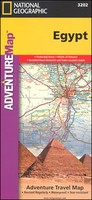
Egypt Adventure Map
Egypt at 1:1, 250, 000 in a series of Adventure maps from the National Geographic Society with cartography provided by Reise Know-How. The map is double-sided, printed on light waterproof and tear-resistant synthetic paper, and covers the whole country, including the whole of the Western Desert and the Sinai, with just the southernmost part of the Red Sea coast shown as an inset.Cartographic information provided by Reise Know-How has been adjusted to follow the house style of the NGS Adventure series with greater emphasis on the country’s topography. Altitude colouring in broader bands has been replaced here by contours at 100m intervals, enhanced by relief shading. Boundaries of national parks and other protected areas are very prominently highlighted.Road network includes desert
tracks and gives driving distances on main routes. Railway lines are included and domestic airports are marked. Internal administrative boundaries are shown with names of the provinces; the map also shows oil pipelines.Symbols highlight numerous places of interest, including UNESCO World Heritage sites, ancient Egyptian and other archaeological remains, monasteries and religious sites, etc. Around El Alamein, often not included on maps which concentrate on covering the Nile Valley and Sinai, locations of war cemeteries and memorials are marked. The map has a latitude and longitude grid at intervals of 1° and an index of place names. Overall, the NGS map presents a more vivid picture of the country’s topography, whilst the original RK-H version provides clearer information for
touring the country by road or rail.PLEASE NOTE: to ensure regular supplies and faster delivery to our customers we keep this title in regular stock in its Reise Know-How edition. The NGS versions can be ordered on request.

Product Description
Reviews/Comments
Add New
Vouchers
No voucher codes found.
Do you know a voucher code for this product or supplier? Add it to Insights for others to use.
Do you know a voucher code for this product or supplier? Add it to Insights for others to use.
 Denmark