
 United Kingdom
 France
 Germany
 Netherlands
 Sweden
 USA
USA
 Italy
Italy
 Spain
Spain
More From Contributor


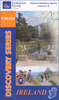

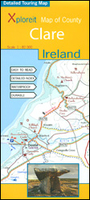
Clare County
County Clare at 1:80, 000 in a series of double-sided, GPS-compatible maps from Xploreit Maps, with contours, altitude colouring, hiking trails and cycling routes, and printed on light, waterproof and tear-resistant plastic paper.Topography is shown by altitude colouring with contours (interval varies) and plenty of names of geographical features. Road network includes local secondary roads and tracks and gives driving distances on main routes. Scenic routes are highlighted. Railway lines are shown with station; local airports, harbours/marinas, and passenger ferry connections are also marked. An overprint highlights local waymarked hiking paths, long-distance walking trails and cycle routes. A wide range of symbols indicate various places of interest; antiquities, leisure
facilities, museums and heritage sites, tourist information centres, campsites and caravan parks, etc. Each map is indexed and has latitude and longitude lines at intervals of 5’ and 10’ respectively, plus in the margin Irish national grid.
facilities, museums and heritage sites, tourist information centres, campsites and caravan parks, etc. Each map is indexed and has latitude and longitude lines at intervals of 5’ and 10’ respectively, plus in the margin Irish national grid.

Product Description
Reviews/Comments
Add New
Intelligent Comparison
Archived Product
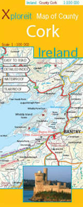
Cork County Stanfords
£12.50
Archived Product
Crow Country Stanfords
£9.99
Archived Product
Crow Country Stanfords
£6.99
Archived Product
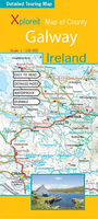
Galway County Stanfords
£12.50
Vouchers
No voucher codes found.
Do you know a voucher code for this product or supplier? Add it to Insights for others to use.
Do you know a voucher code for this product or supplier? Add it to Insights for others to use.
 Denmark