More From Contributor
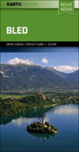
£12.99
Topographic survey of France at 1:25, 000 in IGN`s excellent TOP25 / Série Bleue series. All the maps are GPS compatible, with a 1km UTM grid plus latitude & longitude lines at 5’ intervals. Contours are at 5m intervals except for mountainous areas where the maps have contours at 10m intervals, vividly enhanced by hill shading & graphics for rocky terrain. Colouring with graphics indicates different types of vegetation or land use (deciduous or coniferous forests, moors, orchards, vineyards, etc). PLEASE NOTE: coverage of France at this scale is currently being revised – the format & the presentation of each title are indicated by the letters at the end of its Sheet Reference number (e.g. 0416ET, 3531ETR, 1923SB, etc.)MAPS WITH FULL TOURIST OVERPRINT & AN ENGLISH MAP LEGEND: all TOP25 maps & the SB editions of Série Bleue have an overprint highlighting waymarked walking trails including long-distance GR routes &, where appropriate, ski routes. Symbols indicate campsites, gîtes d’etape, refuges, equestrian centres & other recreational facilities or sites, tourist information centres, cultural heritage, etc. Towns & locations of particular interest are highlighted.- ET or OT = single-sided TOP25 map covering approx. 29x 21 km / 18x 13 miles.- ETR or OTR = waterproof & tear resistant TOP25 map covering the same area as the corresponding ET or OT number, but double-sided, printed on a smaller size sheet with a good overlap between the sides.- SB = Série Bleue map with full tourist overprint; these maps, first introduced in summer 2014, each cover approx. 29x 24km / 18x 15 miles.SÉRIE BLEUE maps with numbers ending in E (Est) or O (Ouest): most editions now indicate the GR routes, but do not show any other tourist information. Map legend is in French only. Each map covers approx. 14x 20km / 9x 12 miles. ...
Archived Product
£1.99
Bleak House is one of Dickens` finest achievements, establishing his reputation as a serious & mature novelist, as well as a brilliant comic writer. It is at once a complex mystery story that fully engages the reader in the work of detection, & an unforgettable indictment of an indifferent society. Its representations of a great city`s underworld, & of the law`s corruption & delay, draw upon the author`s personal knowledge & experience. But it is his symbolic art that projects these things in a vision that embraces black comedy, cosmic farce, & tragic ruin. In a unique creative experiment, Dickens divides the narrative between his heroine, Esther Summerson, who is psychologically interesting in her own right, & an unnamed narrator whose perspective both complements & challenges hers. ...
Archived Product
£8.99
` Perfect` Lena Dunham ` This year`s literary sensation` Evening Standard How far would you travel to become a writer?8000 miles from home 1085 calories a day 3 months to write the novel that would make her name. At least that was the plan. But when Nell Stevens travelled to Bleaker Island in the Falklands (official population: two) she didn`t count on the isolation getting to her... Hilarious & heartbreaking, this is a book about loneliness & creativity. It is about discovering who you are when there`s no one else around. & it`s about what to do when a plan doesn`t work: ultimately Nell may have failed to write a novel, but she succeeded in becoming a writer. ...
Archived Product
£12.99
` My favourite debut of 2017.. .as funny as it is poignant` Lena Dunham When Nell Stevens was given the opportunity to spend three months in a location of her choice in order to write her novel, she was determined to rid herself of all distractions. So Nell decided to travel to Bleaker Island (official population: two) in the Falklands where she would write 2, 500 words a day. But Bleaker House is not that novel. Instead this is a book about a young woman realising that the way to writing fiction doesn`t necessarily lie in total solitude & a clear plan. Nor does it lie in a daily ration of 1085 calories, no means of contacting the outside world & a slow descent towards something that feels worryingly like madness.. . Hilariously funny, painfully honest, & beautifully observed, Bleaker House is part memoir, part travelogue, part story collection. It is an exploration of the narrow spaces between real life & fiction &, in the end, a book about failing to write a novel, but finally becoming a writer. ...
Archived Product
£10.99
When a prostitute & her ill-fated lover are killed in a gruesome double murder, seasoned investigator Detective Hanash is called in. The case draws him into Casablanca`s slums, blighted by criminality, religious extremism, & despair. Hanash`s years on the job have made him intimately familiar with the city`s seedy underbelly, but this time he harbors a personal connection to one of the victims, one he must conceal at all costs. ...
Archived Product
£23.99
Blefjell area in Norway in a series of GPS compatible recreational Turkart maps at 1:50, 000 with cartography from Norway’s topographic survey & additional tourist information. Contours lines are drawn at 20m intervals. The overprint varies from title to title, but

Includes::
local footpaths, in some cases distinguishing between easy & more difficult trails, as well as mountain huts & campsites. Many titles also indicate cycle or ski routes, other accommodation possibilities, sport & recreational facilities, including alpine skiing slopes, places of interest, etc. The maps have a UTM grid & margin ticks giving latitude & longitude. Map legend

Includes::
English. Several titles have on the reverse additional tourist information, although in most cases in Norwegian only. To see the list of Turkart maps at 1:50, 000 & links to Turkart series at 25K, 100K & Hiking Sets please click on the series link above.


...
Archived Product
£9.50
Topographical survey of Belgium at 1:20, 000 from Nationaal Geografisch Instituut / Institut Géographique National, the country’s national survey organization. Each 20K map covers one quarter of the corresponding 1:50, 000 map (with adjustments in the border & coastal areas). The maps provide all the information expected of topographic mapping at this scale & in addition have an unusually large amount of vegetation and/or land use information (different types of woodlands, gardens, orchards, heath, etc). The maps have a 1-km UTM grid, with margin ticks for latitude & longitude at intervals of 1`. Map legend & a glossary of terms used on the maps include English. Stanfords keeps as regular stock 20K maps for the World War I battlefields around the Ypres, Messines & Passchendaele, & for the area of the Battle of Waterloo. The 1:20, 000 survey covers the whole of Belgium & maps for other regions can be supplied as special orders. To see the list of titles in this series please click on the series link.PLEASE NOTE: the Long-Distance Footpaths Map of Belgium at 1:300, 000 which shows the division of Belgium into the 50K survey sheets can also be used to see in more detail coverage by the 20K maps. ...
Archived Product
£19.95
One of the titles in the 1:50, 000 topographic survey of Icel&. The series is not complete. So far 102 maps have been published, out of the total of 199, with the north-west & the east of the country not yet covered. The series has been compiled from aerial photography & has contours at 20m intervals. The maps do not give as much information on the type of the terrain & land use as the 1:100, 000 series, but the cartography

Includes::
many other

Features:
hot & cold springs & wells, streams graded by width, etc. Each map covers an area of Approx. 23 x 28 km / 14 x 17 miles. The maps have a UTM grid, with margin ticks showing latitude & longitude in steps of 5'. Map legend

Includes::
English.


...
Archived Product
£19.99
The southern part of Sweden in a series of 30 double-sided cycling maps from Norstedts printed on light, waterproof & tear-resistant synthetic paper. Mainland is covered at 1:90, 000 with Gotland at 1:100, 000. The maps, prepared in association with Cykelfrämjandet
- Sweden’s largest national cycling organization, highlight all the national & other major cycle routes, plus a selection of local routes. The overprint indicates sections which are on gravel roads and/or not singposted. Also marked are selected hiking trails. A range of symbols indicate various facilities & places of interest, including campsites & youth hostels, wind shelters, cultural & historical sites, interesting nature & geological spots, etc. The maps provide a very detailed picture of the road network, including privately maintained roads open to the general public. Railway lines are shown with stations & ferry connections are marked. Topography is indicated by light relief shading with spot heights, plus colouring and/or graphics for forests & marshl&. The maps have a UTM grid, plus latitude & longitude lines at intervals of 10’. Map legend

Includes::
English. Each map also provides phone numbers & web addresses of local tourist offices.


...
Archived Product
£19.95
Blekinge Province Cycling Map in a series of 30 double-sided maps from Norstedts of the southern part of Sweden, printed on light, waterproof & tear-resistant synthetic paper. Mainland is covered at 1:90, 000 with Gotland at 1:100, 000. The maps, prepared in association with Cykelfr ...
Archived Product

Bled Pocket Map

Bled and its lake in the Julian Alps at 1:25, 000 on a contoured, GPS compatible pocket map from Kartografija highlighting hiking and cycling trails, plus extensive notes about the area and its sights, lists of tourist accommodation, recommendations for restaurants and tavernas, etc.Kartografija’s pocket hiking maps at 1:25, 000 show walking trails and cycling routes, along with numerous tourist facilities and recreational sites. Topography is shown by contours at 20m intervals enhanced by relief shading and graphic relief to show exposed rocky areas, plus colouring for woodlands. Hiking trails and cycling routes are prominently highlighted, and symbols indicate locations of various accommodation options including campsites and mountain huts, sport and recreational sites and
facilities, natural features of particular interest, etc. The maps have a grid with latitude and longitude lines at 1’ intervals. Map legend includes English.On the reverse each map has extensive bilingual Slovenian/English text with more tourist information, illustrated with colour photos.To see the list of all the titles in this series please click on the series link.
RIP - This product is no longer available on our network. It was last seen on 25.09.2019

This page now acts as a permanent archive for this product. Add more information using the comments box below to ensure it can still be found by future generations.

Use our search facility to see if it is available from an alternative contributor.
  • External links may include paid for promotion
  • Availability: Out Of Stock
  • Supplier: Stanfords
  • SKU: 3830048523202
Availability: In Stock
£8.99

Product Description

Bled & its lake in the Julian Alps at 1:25, 000 on a contoured, GPS compatible pocket map from Kartografija highlighting hiking & cycling trails, plus extensive notes about the area & its sights, lists of tourist accommodation, recommendations for restaurants & tavernas, etc. Kartografija’s pocket hiking maps at 1:25, 000 show walking trails & cycling routes, along with numerous tourist facilities & recreational sites. Topography is shown by contours at 20m intervals enhanced by relief shading & graphic relief to show exposed rocky areas, plus colouring for woodlands. Hiking trails & cycling routes are prominently highlighted, & symbols indicate locations of various accommodation options including campsites & mountain huts, sport & recreational sites & facilities, natural features of particular interest, etc. The maps have a grid with latitude & longitude lines at 1’ intervals. Map legend

Includes::
English. On the reverse each map has extensive bilingual Slovenian/ English text with more tourist information, illustrated with colour photos. To see the list of all the titles in this series please click on the series link.

Reviews/Comments

Add New

Intelligent Comparison

Oooops!
We couldn't find anything!
Perhaps this product's unique.... Or perhaps we are still looking for comparisons!
Click to bump this page and we'll hurry up.

Price History

Vouchers

No voucher codes found.
Do you know a voucher code for this product or supplier? Add it to Insights for others to use.

Facebook

Jargon Buster

GPS - Global Positioning System - Global position using satellites
Hiking - An outdoor activity envolving walking in nature
Colour - The categorised spectrum of light visable to humans
Natural - not manmade
Accommodation - A room in which someone can live in, for example in a hotel
Pocket - A bag shaped insert in clothing used to carry items

Supplier Information

Stanfords
Stanfords was established in 1853 and opened their iconic Covent Garden flagship store in 1901. They have become the top retailer of maps, travel books and accessories in the UK and arguably offer the largest selection of maps and travel books worldwide. Famous names such as Captain Robert Falcon Scott, Ranulph Fiennes and Michael Palin have purchased from Stanfords. They now have a shop in Bristol and both stores together with other venues operate a calendar of events including talks, book signings and exhibitions. As a specialist map retailer, the map selection is comprehensive and includes road maps, street maps and walking maps from worldwide destinations, as well as a selection of world atlases and wall maps. Books include travel guides and travel literature. Stanfords also stock globes, from miniatures made of blue marble to magnificent floor-standing globes. The website features a selection of interesting articles on travel topics.
Page Updated: 2023-11-12 20:15:36

Community Generated Product Tags

Oh No! The productWIKI community hasn't generated any tags for this product yet!
Menu