
 United Kingdom
 France
 Germany
 Netherlands
 Sweden
 USA
USA
 Italy
Italy
 Spain
Spain
More From Contributor

Bhutan Great Himalaya Trail Map
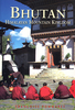
Bhutan: Great Himalaya Trail Map at 1:400, 000 from the Kathmandu-based Nepa Maps with the overprint distinguishing between the course of the Great Himalaya Trail and other traditional trekking routes; plus a route profile of the GHT and other useful trekking information.Satellite-derived base provides a good representation of the country’s topography; main rivers, peaks and mountain passes are named and national parks or other protected areas are marked. The map shows the country’s road network plus highlights numerous trekking routes. The overprint for the Great Himalaya Trail clearly distinguishes it from other trekking routes and highlights locations of suggested stopovers. Symbols across the whole map indicate base camps, locations with tourist accommodation, various religious
sites, museums, etc. Latitude and longitude lines are drawn at 30’ intervals. The map has no index.Also provided is a route profile showing altitude and distances along the Great Himalaya Trail, as well as a list of 45 stages with walking times and altitude of camp sites, plus the GHT code. Further tables show monthly temperatures at various locations in Bhutan, wind chill and heat indexes. All the information is in English.
sites, museums, etc. Latitude and longitude lines are drawn at 30’ intervals. The map has no index.Also provided is a route profile showing altitude and distances along the Great Himalaya Trail, as well as a list of 45 stages with walking times and altitude of camp sites, plus the GHT code. Further tables show monthly temperatures at various locations in Bhutan, wind chill and heat indexes. All the information is in English.
Product Description
Reviews/Comments
Add New
Vouchers
No voucher codes found.
Do you know a voucher code for this product or supplier? Add it to Insights for others to use.
Do you know a voucher code for this product or supplier? Add it to Insights for others to use.
 Denmark