More From Contributor

£13 GBP
Perfect for day trips & short breaks in & around Kendal, Morecambe, Windermere & Lancaster this OS Landranger map utilises a 1:50, 000 scale. It

Includes::
places of interest, tourist information, picnic areas & camping sites, plus Rights of Way information for England & Wales.

...
Archived Product
£13 GBP
Covering Kielder Water & Forest on a 1:25, 000 scale however remote the terrain, this Ordnance Survey Explorer map will give you the accurate, detailed information you need to navigate the area safely. Rights of way, fences, permissive paths & bridleways are clearly shown, ensuring you have the best information to get the most out of your time in the countryside. These are the map of choice for many walkers, climbers, off-road cyclists, horse riders & anyone involved in outdoor activities. ...
Archived Product
£8.99

Perfect for day trips & short breaks, the OS Landranger Map series covers Great Britain with 204 detailed maps. each map provides

...
Archived Product
£13 GBP
Perfect for day trips & short breaks in & around Kingussie & Monadhliath Mountains this OS Landranger map utilises a 1:50, 000 scale. It

Includes::
places of interest, tourist information, picnic areas & camping sites, plus Rights of Way information for England & Wales.

...
Archived Product
£13 GBP
Covering Knoydart, Loch Hourn & Loch Duich on a 1:25, 000 scale however remote the terrain, this Ordnance Survey Explorer map will give you the accurate, detailed information you need to navigate the area safely. Rights of way, fences, permissive paths & bridleways are clearly shown, ensuring you have the best information to get the most out of your time in the countryside. These are the map of choice for many walkers, climbers, off-road cyclists, horse riders & anyone involved in outdoor activities. ...
Archived Product
£8.99

Perfect for day trips & short breaks, the OS Landranger Map series covers Great Britain with 204 detailed maps. each map provides

...
Archived Product
£13 GBP
Perfect for day trips & short breaks in & around Lairg, Loch Shin & Loch Naver this OS Landranger map utilises a 1:50, 000 scale. It

Includes::
places of interest, tourist information, picnic areas & camping sites, plus Rights of Way information for England & Wales.

...
Archived Product
£13 GBP
Covering Land's End, Penzance & St Ives on a 1:25, 000 scale however remote the terrain, this Ordnance Survey Explorer map will give you the accurate, detailed information you need to navigate the area safely. Rights of way, fences, permissive paths & bridleways are clearly shown, ensuring you have the best information to get the most out of your time in the countryside. These are the map of choice for many walkers, climbers, off-road cyclists, horse riders & anyone involved in outdoor activities. ...
Archived Product
£26.99
The OS Scafell Pike Large Microfibre Towel will be a favourite for camping, wild swimming, gym sessions & more! It's super soft to the touch, lightweight, highly absorbent, & dries eight times faster than the average towel. It packs down small & can be neatly stowed away at a moment's notice. The Polygiene permanent odour control helps keep away bad smells, making it ideal for long camping trips in the Lake District! ...
Archived Product
£26.99
The OS Yr Wyddfa (Snowdon) Large Microfibre Towel is super soft to the touch, lightweight, highly absorbent, & dries eight times faster than the average towel. It packs down small & can be neatly stowed away at a moment's notice – perfect for a backpacking trip in North Wales! The Polygiene permanent odour control helps keep away bad smells, even over a long holiday. ...
Archived Product

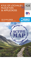
Ordnance Survey Kyle Of Lochalsh, Plockton & Applecross OS Explorer
428 Map

Covering Kyle of Lochalsh, Plockton & Applecross on a 1:25, 000 scale however remote the terrain, this Ordnance Survey Explorer map will give you the accurate, detailed information you need to navigate the area safely. Rights of way, fences, permissive paths and bridleways are clearly shown, ensuring you have the best information to get the most out of your time in the countryside. These are the map of choice for many walkers, climbers, off-road cyclists, horse riders and anyone involved in outdoor activities.
RIP - This product is no longer available on our network. It was last seen on 17.10.2012

This page now acts as a permanent archive for this product. Add more information using the comments box below to ensure it can still be found by future generations.

Use our search facility to see if it is available from an alternative contributor.
  • Availability: Out Of Stock
  • Supplier: Ellis Brigham
  • SKU: 178428900076
Availability: In Stock
£13 GBP

Product Description

Covering Kyle of Lochalsh, Plockton & Applecross on a 1:25, 000 scale however remote the terrain, this Ordnance Survey Explorer map will give you the accurate, detailed information you need to navigate the area safely. Rights of way, fences, permissive paths & bridleways are clearly shown, ensuring you have the best information to get the most out of your time in the countryside. These are the map of choice for many walkers, climbers, off-road cyclists, horse riders & anyone involved in outdoor activities.

Reviews/Comments

Add New

Price History

Vouchers

No voucher codes found.
Do you know a voucher code for this product or supplier? Add it to Insights for others to use.

Facebook

Jargon Buster

Road - a manmade lane or a path that is used to speed up travel.
Horse - A large animal with four legs that tends to be ridden.
Accurate - A measurement of precision when all elements are correct.

Supplier Information

Page Updated: 2025-01-23 12:39:29

Community Generated Product Tags

Oh No! The productWIKI community hasn't generated any tags for this product yet!
Menu