More From Contributor

£114.95
An easy to use GPS sports watch featuring a comfortable Heart Rate Monitor (HRM) strap, & including a ANT+ wireless connection to accessories, & to the included USB stick to your PC. Blue colour option. If you are looking for a GPS sports watch with the simplicity of the popular  Fore Runner 10 but with additional heart rate monitoring options & wireless connectivity, then the Forerunner 70 in either blue or pink colourway is the GPS watch for you. You can also switch between sports activities at the touch of a button, making this a great GPS watch for those doing different sports, but still looking for something that is not heavily laden with features that wont be used. FEATURES FR70 is a simple-to-use sportswatch that is ideal for all-round fitness ANT connectivity allows the use of the supplied Heart rate monitor as well as Garmin speed/cadence sensors or foot pods It tracks exercise data whether running or cycling, in the gym or outside, & comes with Garmins premium soft strap heart rate monitor so you can check your cardio performance & calories burned during training Create interval workouts, tailor your sessions or set alerts when its time to rest Switch between sport modes at the press of a button Use the Virtual Partner function (when paired with optional foot pod) to race over a specified distance A wireless transfer feature sends training data to your computer via the included USB (Universal Serial Bus) ANT stick as soon as FR70 is in range, so you can analyse your performance on Garmin Connect Weight: 44 grams Display: W x H, 2.0 x 2.8 cm Display resolution: W x H, 31 x 56 pixels

Size:
W x H x D, 3.8 x 5.6 x 1.3 cm

...
Archived Product
£114.95
An easy to use GPS sports watch featuring a comfortable Heart Rate Monitor (HRM) strap, & including a ANT+ wireless connection to accessories, & to the included USB stick to your PC. Pink & black colour option. If you are looking for a GPS sports watch with the simplicity of the popular  Fore Runner 10 but with additional heart rate monitoring options & wireless connectivity, then the Forerunner 70 in either blue or pink colourway is the GPS watch for you. You can also switch between sports activities at the touch of a button, making this a great GPS watch for those doing different sports, but still looking for something that is not heavily laden with features that wont be used. FEATURES FR70 is a simple-to-use sportswatch that is ideal for all-round fitness ANT connectivity allows the use of the supplied Heart rate monitor as well as Garmin speed/cadence sensors or foot pods It tracks exercise data whether running or cycling, in the gym or outside, & comes with Garmins premium soft strap heart rate monitor so you can check your cardio performance & calories burned during training Create interval workouts, tailor your sessions or set alerts when its time to rest Switch between sport modes at the press of a button Use the Virtual Partner function (when paired with optional foot pod) to race over a specified distance A wireless transfer feature sends training data to your computer via the included USB (Universal Serial Bus) ANT stick as soon as FR70 is in range, so you can analyse your performance on Garmin Connect Weight: 44 grams Display: W x H, 2.0 x 2.8 cm Display resolution: W x H, 31 x 56 pixels

Size:
W x H x D, 3.8 x 5.6 x 1.3 cm

...
Archived Product
£289.99
A data laden multi sports & triathlon GPS watch that does far more than log the basics, with detailed tracking of swimming, running & cycling activities available and  Hotfix GPS for rapid & stable satellite data. FEATURES The Forerunner 910XT is the most advanced triathlon & multi sport watch yet & is sure to please even the most data hungry athletes The 910XT provides detailed swim metrics & tracks distance, pace, elevation (via barometric altimeter) & heart rate for running & cycling Designed for open water & pool swimming, it records distance, efficiency, stroke type, stroke count & pool lengths The 910XT is water resistant to 50 metres & has up to 20 hours of battery life, making it ideal to be used at Ironman events ANT compatibility means the 910XT can be used with compatible heart rate monitors, cadence sensors, food pods & power meters Optional vibration alerts for space, pace or heart rate High sensitivity GPS for Hotfix for a rapid & stable satellite lock Once your workout is done, data is sent wirelessly to your computer for detailed analysis, mapping & data sharing at Garmin Connect Despite the number of features the 910XT still only weighs 72 grams, so it wont slow you down Packages available are watch only, watch with heart rate strap, or a triathlon bundle with heart rate strap, bicycle cadence sensor & handlebar mount   WHATS IN THE BOX? Watch Only Version Forerunner 910XT GPS Watch USB (Universal Serial Bus) ANT Stick™ AC charger Charging clip Expander strap Quickstart Guide   Heart Rate Monitor Version Forerunner 910XT GPS Watch Premium heart rate monitor USB (Universal Serial Bus) ANT Stick AC charger Charging clip Expander strap Quickstart Guide Triathlon Bundle Version Forerunner 910XT GPS Watch USB (Universal Serial Bus) ANT Stick Premium Heart Rate Monitor (Soft Strap) Speed & Cadence Sensor Quick release kit Charging clip Expander strap AC charger Quickstart Guide   ...
Archived Product
£42.95
An optional add on item for compatible Garmin GPS units & watches with ANT wireless technology, to allow you to use on a bicycle & record & monitor cadence & speed. FEATURES Monitor your pedaling cadence as you ride with this self-calibrating, wireless speed/cadence sensor It measures & reports your pedalling strokes per minute, providing feedback for optimal performance Compatible with many Garmin models that have ANT or ANT+ wireless technology such as Forerunner watches & Outdoor units   ...
Archived Product
£74.95
An advanced heart rate transmitter belt for the Garmin Forerunner 620 which gives additional data to your watch thanks to built in accelerometer technology passing on oscillations & movements. A heart rate transmitter with additional features providing real-time feedback on running form By sensing torso movement running form metrics can be computed Cadence, ground contact time & vertical oscillation are all calculated & sent direct to your FR620 Requires pairing with the Forerunner 620 to utilise all features of this heart rate transmitter   ...
Archived Product
£294.95
The Garmin 600 GPS unit is a tough touch screen based GPS mapping unit for the explorer requiring a reliable & easy to use GPS system. This is the base model with built in worldwide base map. FEATURES Tough, glossy
- sun light readable, glove friendly, enhanced colour touch screen GPS/GLONASS satellite for accurate satellite tracking Built-in worldwide base map with shaded relief give you all the tools for serious climbing or hiking 3-axis compass, accelerometer & barometric altimeter Wireless sharing via Bluetooth or ANT Multi touch with pinch to zoom Portrait & landscape orientation Advanced elevation dynamics & Future plot shows you what has been done & what is coming up enhanced user interface with profiles Can hold up to 4 million Geo caching points! Dual power battery device Either use AA or the included rechargeable battery IPX-7 waterproof Unit

Dimensions (cm)
- W x H x D: 5.8 x 11.4 x 3.5 Display size (cm)
- W x H: 3.8 x 6.3
- diagonal: 7.6 cm A bicycle mount can be purchased separately for this unit

Specification Product Type: GPS/GLONASS receiver Recommended Use: hiking Preloaded Maps: Worldwide base map only Card Reader: micro SD Interface: USB (Universal Serial Bus) 2.0 Functions & Services: electronic compass Included Software NAVTEQ Compatible Software: Map Source City Navigator Antenna :built-in Internal Memory: 1.5 GB flash

Features:
automatic routing Display Type: TFT
- color
- touch screen Diagonal

Size:
3

Width:
1.5 in

Height:
2.5 in Resolution: 240 x 400

Features:
transflective treatment for sun light reading Waypoints: 4000 Tracks: 200 Tracklog Points: 10000 Routes: 200 Battery Run Time (Up To) 16 hours Waterproof: Standard IPX7 Included Accessories: USB (Universal Serial Bus) charging cable  


...
Archived Product
£359.00
The Garmin 600 GPS unit is a tough touch screen based GPS mapping unit for the explorer requiring a reliable & easy to use GPS system. This is the 600t which is pre-loaded with European Recreational maps. Further maps can be added via the Micro SD card slot from a wide range of available Garmin map modules. The unit features a Lithium Ion rechargeable battery but can also be run with AA batteries when needed.   FEATURES Tough, glossy
- sun light readable, glove friendly, enhanced colour touch screen GPS/GLONASS satellite for accurate satellite tracking Built-in worldwide base map with shaded relief give you all the tools for serious climbing or hiking 3-axis compass, accelerometer & barometric altimeter Wireless sharing via Bluetooth or ANT Multi touch with pinch to zoom Portrait & landscape orientation Advanced elevation dynamics & Future plot shows you what has been done & what is coming up enhanced user interface with profiles Can hold up to 4 million Geo caching points! Dual power battery device Either use AA or the included rechargeable battery IPX-7 waterproof Unit

Dimensions (cm)
- W x H x D: 5.8 x 11.4 x 3.5 Display size (cm)
- W x H: 3.8 x 6.3
- diagonal: 7.6 cm A bicycle mount can be purchased separately for this unit

Specification Product Type: GPS/GLONASS receiver Recommended Use: hiking Preloaded Maps: Worldwide base map & pre-loaded with European Recreational Map book Card Reader: micro SD Interface: USB (Universal Serial Bus) 2.0 Functions & Services: electronic compass Included Software NAVTEQ Compatible Software: Map Source City Navigator Antenna :built-in Internal Memory: 1.5 GB flash

Features:
automatic routing Display Type: TFT
- color
- touch screen Diagonal

Size:
3

Width:
1.5 in

Height:
2.5 in Resolution: 240 x 400

Features:
transflective treatment for sun light reading Waypoints: 4000 Tracks: 200 Tracklog Points: 10000 Routes: 200 Battery Run Time (Up To) 16 hours Waterproof: Standard IPX7 Included Accessories: USB (Universal Serial Bus) charging cable  


...
Archived Product
£354.95
The Garmin 650 GPS unit is a tough touch screen based GPS mapping unit with 8MP built in camera for the explorer requiring a reliable & easy to use GPS system. This version

Includes::
a base worldwide map. The 8MP camera means that you can take photos & tag them from the exact location to give you a historical record, & to help with waypoint recognition when revisiting a route. Further maps can be added via the Micro SD card slot from a wide range of available Garmin map modules. The unit features a Ni MH rechargeable battery but can also be run with AA batteries when needed.   FEATURES Tough, glossy
- sun light readable, glove friendly, enhanced colour touch screen 8 Mega Pixel (MP) camera built in with quick access button GPS/GLONASS satellite for accurate satellite tracking Built-in worldwide base map with shaded relief give you all the tools for serious climbing or hiking 3-axis compass, accelerometer & barometric altimeter Wireless sharing via Bluetooth or ANT Multi touch with pinch to zoom Portrait & landscape orientation Advanced elevation dynamics & Future plot shows you what has been done & what is coming up enhanced user interface with profiles Can hold up to 4 million Geo caching points! Dual power battery device Either use AA or the included rechargeable battery IPX-7 waterproof Unit

Dimensions (cm)
- W x H x D: 5.8 x 11.4 x 3.5 Display size (cm)
- W x H: 3.8 x 6.3
- diagonal: 7.6 cm A bicycle mount can be purchased separately for this unit

Specification Product Type: GPS/GLONASS receiver Recommended Use: hiking 8MP camera Preloaded Maps: Worldwide base map Card Reader: micro SD Interface: USB (Universal Serial Bus) 2.0 Functions & Services: electronic compass Included Software NAVTEQ Compatible Software: Map Source City Navigator Antenna :built-in Internal Memory: 1.5 GB flash

Features:
automatic routing Display Type: TFT
- color
- touch screen Diagonal

Size:
3

Width:
1.5 in

Height:
2.5 in Resolution: 240 x 400

Features:
transflective treatment for sun light reading Waypoints: 4000 Tracks: 200 Tracklog Points: 10000 Routes: 200 Battery Run Time (Up To) 16 hours Waterproof: Standard IPX7 Included Accessories: USB (Universal Serial Bus) charging cable  


...
Archived Product
£409.95
The Garmin 650t GPS unit is a tough touch screen based GPS mapping unit with 8MP built in camera for the explorer requiring a reliable & easy to use GPS system.

Includes::
Europe Recreational Maps pre-loaded onto the device The 8MP camera means that you can take photos & tag them from the exact location to give you a historical record, & to help with waypoint recognition when revisiting a route. Further maps can be added via the Micro SD card slot from a wide range of available Garmin map modules. The unit features a Ni MH rechargeable battery but can also be run with AA batteries when needed.   FEATURES Tough, glossy
- sun light readable, glove friendly, enhanced colour touch screen 8 Mega Pixel (MP) camera built in with quick access button GPS/GLONASS satellite for accurate satellite tracking Built-in worldwide base map with shaded relief give you all the tools for serious climbing or hiking 3-axis compass, accelerometer & barometric altimeter Wireless sharing via Bluetooth or ANT Multi touch with pinch to zoom Portrait & landscape orientation Advanced elevation dynamics & Future plot shows you what has been done & what is coming up enhanced user interface with profiles Can hold up to 4 million Geo caching points! Dual power battery device Either use AA or the included rechargeable battery IPX-7 waterproof Unit

Dimensions (cm)
- W x H x D: 5.8 x 11.4 x 3.5 Display size (cm)
- W x H: 3.8 x 6.3
- diagonal: 7.6 cm A bicycle mount can be purchased separately for this unit

Specification Product Type: GPS/GLONASS receiver Recommended Use: hiking 8MP camera Preloaded Maps: Worldwide base map & European Recreational Map Book Card Reader: micro SD Interface: USB (Universal Serial Bus) 2.0 Functions & Services: electronic compass Included Software NAVTEQ Compatible Software: Map Source City Navigator Antenna :built-in Internal Memory: 1.5 GB flash

Features:
automatic routing Display Type: TFT
- color
- touch screen Diagonal

Size:
3

Width:
1.5 in

Height:
2.5 in Resolution: 240 x 400

Features:
transflective treatment for sun light reading Waypoints: 4000 Tracks: 200 Tracklog Points: 10000 Routes: 200 Battery Run Time (Up To) 16 hours Waterproof: Standard IPX7 Included Accessories: USB (Universal Serial Bus) charging cable  


...
Archived Product
£47.95
A premium version of the Garmin Heart Rate monitor strap featuring a super-soft strap for enhanced comfort, & a superior battery life. Compatible with ANT based monitors & gym equipment. FEATURES The robust ANT wireless heart rate monitor This premium edition is equipped with super soft, exceptionally comfortable chest strap Offers superior battery life Eliminates cross-talk with other devices to reliably measure & send heart rate data to help you train in your zone   ...
Archived Product

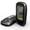
Garmin Montana 600 GPS Handheld Unit With Base Worldwide Map

The next generation in rugged touch screen GPS mapping devices, the Montana features a rich 4 inch dual orientation full colour display giving razor sharp results. Base handset with base worldwide map. Add a map pack via the micro-sd slot from the wide range available for an extremely accurate GPS navigation device with unlimited potential.   Navigate with ease: The Montana has key features for the outdoors such as a 3-axis tilt-compensated compass which shows your heading even when you’re standing still, without holding it level. It also has a barometric altimeter which tracks changes in pressure to pinpoint your precise altitude, and you can even use it to plot barometric pressure over time, which can help you keep an eye on changing weather conditions. Go everywhere: Mapping
options include the City Navigator maps for use in the car, BlueChart® g2 preloaded cards for a great day on the water, Garmin GB Discoverer™ which provides Ordnance Survey® mapping on your handheld and BirdsEye™ Select that lets you download customised sections of premium raster-based maps to your device and integrate them with your maps. Montana is also compatible with Custom Maps which transforms paper and electronic maps into downloadable maps for your device. You can even display and enter coordinates in British Grid format, the grid used on Ordnance Survey maps. Share wirelessly: With Montana 600 you can share your waypoints, tracks, routes and geocaches wirelessly with other compatible Garmin GPS users. So now your friends can also enjoy your favourite hike or cache –
simply press “Send” to transfer your information to other units. Geocaching Ready: Montana 600 supports geocaching GPX files to download geocaches and details straight to your unit. Visit OpenCaching.com to start your geocaching adventure. Montana 600 stores and displays key information, such as location, terrain, difficulty, hints and descriptions, which means no more manually entering coordinates and paper print outs! Simply upload the GPX file to your unit and start hunting for caches.   FEATURES The next generation of rugged, waterproof touch screen GPS devices 4 inch dual orientation touch screen is Garmins biggest yet for an outdoor GPS and can display up to 65, 00 colours, giving bright, pin-sharp images Comes preloaded with a basic global base map. For full usability
add a topography map via the micro SD slot. Can be used to share routes, waypoints or geocaches wirelessly with other compatible units High-sensitivity WAAS-enabled GPS reciever with Hotfix for a quick and stable connection, even in heavily forested areas 3-axis barometric compass 3 gigabyte internal memory and microSD card slot for adding additional maps when required Compatible with Raster mapping, City-navigator, Garmin custom maps, Birdseye, satellite and Birdseye Select imagery Can be run off rechargeable battery pack (included) for up to 16 hours, or on 3 x AAs for up to 22 hours WHAT IS IN THE BOX? Handheld unit with basic worldwide base map Lithium-Ion battery pack USB cable AC Charger Quickstart Guide  
RIP - This product is no longer available on our network. It was last seen on 26.10.2016

This page now acts as a permanent archive for this product. Add more information using the comments box below to ensure it can still be found by future generations.

Use our search facility to see if it is available from an alternative contributor.
Availability: In Stock
£374.95

Product Description

The next generation in rugged touch screen GPS mapping devices, the Montana features a rich 4 inch dual orientation full colour display giving razor sharp results. Base handset with base worldwide map. Add a map pack via the micro-sd slot from the wide range available for an extremely accurate GPS navigation device with unlimited potential.   Navigate with ease:  The Montana has key features for the outdoors such as a 3-axis tilt-compensated compass which shows your heading even when you’re standing still, without holding it level. It also has a barometric altimeter which tracks changes in pressure to pinpoint your precise altitude, & you can even use it to plot barometric pressure over time, which can help you keep an eye on changing weather conditions. Go everywhere:  Mapping options include the City Navigator maps for use in the car, Blue Chart® g 2 preloaded cards for a great day on the water, Garmin GB Discoverer™ which provides Ordnance Survey® mapping on your handheld & Birds Eye™ Select that lets you download customised sections of premium raster-based maps to your device & integrate them with your maps. Montana is also compatible with Custom Maps which transforms paper & electronic maps into downloadable maps for your device.  You can even display & enter coordinates in British Grid format, the grid used on Ordnance Survey maps. Share wirelessly:  With Montana 600 you can share your waypoints, tracks, routes & geocaches wirelessly with other compatible Garmin GPS users. So now your friends can also enjoy your favourite hike or cache – simply press “ Send” to transfer your information to other units. Geocaching Ready:  Montana 600 supports geocaching GPX files to download geocaches & details straight to your unit. Visit Open Caching.com to start your geocaching adventure. Montana 600 stores & displays key information, such as location, terrain, difficulty, hints & descriptions, which means no more manually entering coordinates & paper print outs! Simply upload the GPX file to your unit & start hunting for caches.   FEATURES The next generation of rugged, waterproof touch screen GPS devices 4 inch dual orientation touch screen is Garmins biggest yet for an outdoor GPS & can display up to 65, 00 colours, giving bright, pin-sharp images Comes preloaded with a basic global base map. For full usability add a topography map via the micro SD slot. Can be used to share routes, waypoints or geocaches wirelessly with other compatible units High-sensitivity WAAS-enabled GPS reciever with Hotfix for a quick & stable connection, even in heavily forested areas 3-axis barometric compass 3 gigabyte internal memory & micro SD card slot for adding additional maps when required Compatible with Raster mapping, City-navigator, Garmin custom maps, Birdseye, satellite & Birdseye Select imagery Can be run off rechargeable battery pack (included) for up to 16 hours, or on 3 x AAs for up to 22 hours WHAT IS IN THE BOX? Handheld unit with basic worldwide base map Lithium-Ion battery pack USB (Universal Serial Bus) cable AC Charger Quickstart Guide  

Reviews/Comments

Add New

Intelligent Comparison

Oooops!
We couldn't find anything!
Perhaps this product's unique.... Or perhaps we are still looking for comparisons!
Click to bump this page and we'll hurry up.

Price History

Oooops!
We couldn't find any historical pricing!

Vouchers

No voucher codes found.
Do you know a voucher code for this product or supplier? Add it to Insights for others to use.

Facebook

Jargon Buster

USB - Universal Serial Bus
AC - Alternating Current
GPS - Global Positioning System - Global position using satellites
Paper - A thin sheet mainly used for writing. Available in a variety of colours. Made mainly from wood pulp.
Battery - A device used for the storage of electricity
Gigabyte - 1000 megabytes of storage
Inch - Equivalent to approximately 2.5cm
Eye - An organ which detects light
water - A chemical substance. Chemical formula H2O.
razor - A bladed tool used to remove hair from the body by shaving.
Key - A physical or virtual device or code used for opening something
Cable - A series of wires bonded to form a single thread
Waterproof - Resistant to water, usualy specified by depth in metres
Friends - A close associate or a popular US based sitcom about a group of friends
Car - A machine used for transport which runs on roads
Colour - The categorised spectrum of light visable to humans
Day - The time it takes a planet or other space objects to complete one rotation.
Weather - is the change of an atmospheres conditions.
Quick - Something that is fast
USB - Universal Serial Bus. A method of connecting a device to a computer
Adventure - an undertaking of an exciting challenge or experience.
Precise - A measurement on the accuracy of something
Accurate - A measurement of precision when all elements are correct.
Altitude - Something that can be quite high in relation to sea or ground level.
Micro SD - A small Secure Digital removable storage card.
Wide - Something with a large width.
Memory - A way to describe the way in which the brain can remember things.
Print - A mechanical process of putting text onto paper. It can also relate to a pattern on an item.
Rechargeable - Something that can be charged back to its original state, e.g. batteries.

Supplier Information

Edge And Wax
Page Updated: 2015-04-11 04:04:33

Community Generated Product Tags

Oh No! The productWIKI community hasn't generated any tags for this product yet!
Menu