
 United Kingdom
 France
 Germany
 Netherlands
 Sweden
 USA
USA
 Italy
Italy
 Spain
Spain
More From Contributor


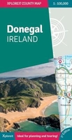
Donegal Xploreit County Map
Xploreit Maps is an Irish publisher of maps and atlases. The Xploreit County Series covers the western coastal counties in a set of double-sided maps ranging from County Cork in the southwest to County Donegal in the northwest. This map of County Donegal highlights local and long distance walking trails, cycle routes and scenic drives. The road network includes local roads with driving distances indicated on the main routes. Parking spots, passenger ferry routes, harbours and local piers are included. Woodland areas, mountains, rivers and lakes clearly marked. A large set of symbols is used to illustrate antiquities, golf courses, museums, heritage centres, beaches for surfing and swimming, campsites, caravan parks and many other local points of interest.Key Points:* All of
Donegal on a single map* Easy to read, clear mapping* Local walks and cycleways* Wild Atlantic Way driving route* Tourist attractions highlighted* Handy street plan of Donegal town* Detailed Index* Scale is 1:100, 000* Map legend in English, German and French
Donegal on a single map* Easy to read, clear mapping* Local walks and cycleways* Wild Atlantic Way driving route* Tourist attractions highlighted* Handy street plan of Donegal town* Detailed Index* Scale is 1:100, 000* Map legend in English, German and French

Product Description
Reviews/Comments
Add New
Vouchers
No voucher codes found.
Do you know a voucher code for this product or supplier? Add it to Insights for others to use.
Do you know a voucher code for this product or supplier? Add it to Insights for others to use.
 Denmark